
Raising the Rocky Mountains
The Geology of the Rockies
Introduction by Sarah Eshleman
I grew up with John Denver’s tenor drifting through the house on Sunday afternoons. In the kitchen, my mother peeled potatoes and sliced roast beef to the tune of “Sunshine on My Shoulders” and “Rocky Mountain High.”
All my life, I knew Mom had one dream: to visit the Colorado Rockies mentioned in John Denver’s ballads. But why the obsession with a place she’d never seen? I didn’t get it.
For their twenty-fifth anniversary, my parents trekked to the Centennial State. But after looking at her glossy snapshots from Pike’s Peak and Garden of the Gods, I still didn’t comprehend exactly what had compelled her pilgrimage. Having grown up in the foothills of the Blue Ridge mountains, I wondered what was so special about just another mountain range.
Last year, I attended the Evangelical Press Association conference in Colorado Springs. The resort sat almost at the base of Cheyenne Mountain. For the first half hour, I stood on the patio staring at the mountain. I felt like that guy John Denver sang about who came home to a place he’d never before seen. At last, I understood Mom’s devotion.
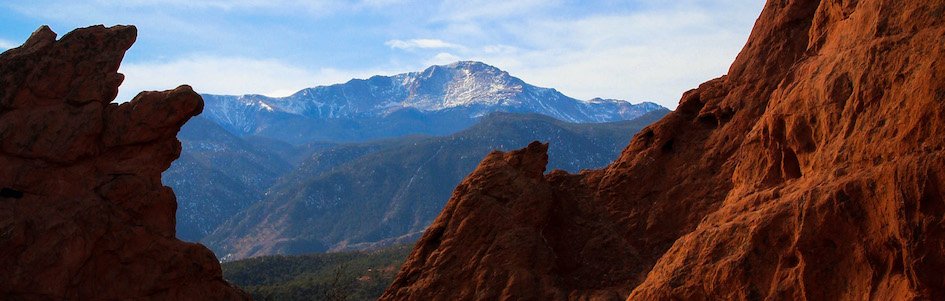
The Rocky Mountains, the largest range in North America, stretch over 3,000 miles (4,800 km) from western Canada to the southwestern United States. The rugged, snow-capped summits make a grand winter playground especially for bold skiers seeking out fourteeners—mountains elevated over 14,000 feet. These alpinist athletes have their pick. Colorado alone hosts 58 fourteeners, including the highest peak in the Rockies, Mount Elbert (towering at 14,433 feet), and Pikes Peak, the most iconic of them all.
But the Rockies are more than just a pretty mountain face. They provide a continental divide, a natural marker determining if water from precipitation flows to the Pacific or Atlantic Ocean. The drainage affects the continent’s meteorologic activity and dictates ecosystems on either side of the mountains. North America features six such divides, but the Great Continental Divide in the Rockies is the most significant.
Before I started working on the Answers magazine team, the stunning pinnacles might have prompted me to praise the Creator for making such a view. But after years of reading Dr. Andrew Snelling’s geology articles, I know that mountains were indeed formed—though not during creation week. They were raised near the end of the cataclysmic global flood of Noah’s day (Genesis 6:11–13).
But there’s a mystery in these mountains. The Rockies differ from other ranges in a unique way. Most mountains form 200–400 miles (~320–650 km) inland from a subduction zone boundary (a boundary between tectonic plates in which one of those plates is ocean crust that is being pushed under a continental plate). So how did the Rockies rise into existence over 600 miles (~1,000 km) inland from the western US coast?
Of course, evolutionists have their millions-of-years story for how the Rockies rose. But I’ll leave it to Dr. Snelling to give a biblical picture of when and how the Rockies reached their majestic heights so far inland.
The snapshots that Dr. Snelling presents in this article remind me that the Rockies are more than just mountains—they are mementos. Like my mom clinging to her vision of a place she’d never seen before, the Rockies remind us of places we’ve only read about in God’s Word: the pre-flood earth and the new earth to come. I don’t know if in the new creation God will create towering summits for us to scale. But for now, we’re suspended between a past catastrophe and a future promise, surrounded by resplendent scars like the Rockies, reminders of God’s righteous judgment of sin and breathtaking mercy.
One Mountain Range, Two Worldviews
By Dr. Andrew A. Snelling
Any effort to explain the complex geologic processes that formed the Rockies is historical science, interpreting today’s field data to describe past events. That is why the evolutionary story and the biblical creation and flood accounts provide incongruous histories of how these peaks rose to such heights so far inland. Because evolutionary geologists must depend solely on their own ideas about the unobservable past, their story can only ever be conjectural. On the other hand, creation geologists use God’s Word, which details the Creator’s eyewitness account of creation and the flood. Thus, the biblical framework of earth’s history provides a clearer account of the Rockies’ formation.
1 | A Rocky Start
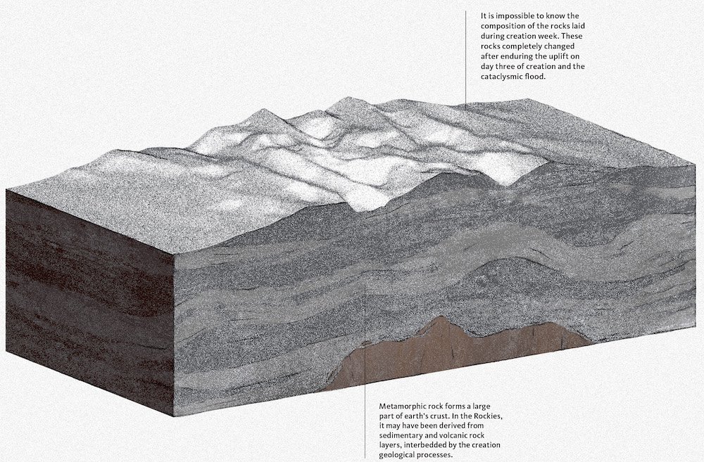
Fig. 1. 6,000 Years Ago (Creation) / 1,800 Million Years Ago (Evolution)
Evolution
1,800 Million Years Ago
The rocky cores of this mountain range consist of pieces of ancient Precambrian (greater than 539 million years old) metamorphic rock intruded by granite that together form the foundation of the North American continent.
Over 1,800 million years ago, thousands of feet of shale, sandstone, and limestone were deposited with interbedded volcanic rocks. Subsequent earth movements compressed, folded, metamorphosed, and uplifted those former sedimentary rocks, while molten rock intruded into them and cooled into granite.
Creation
6,000 Years Ago
God created the earth on the first day of creation week about 6,000 years ago (Genesis 1:1–2). We are not told what rocks God initially formed. However, whatever rocks God laid as the foundations of the earth’s crust (outer skin), today they are not in the same condition as when he created them because they have suffered from the heat, tectonics, and other effects of subsequent events (the uplift on day three of creation and the upheaval during the flood). What we do know is that he spoke, and the foundations appeared immediately just as he planned (Job 38:4).
2 | Molten Uplift
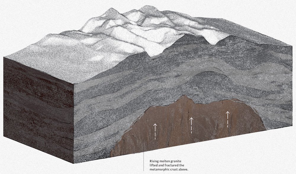
Fig. 2. 6,000 Years Ago (Creation) / 1,450 Million Years Ago (Evolution)
Evolution
1,450 Million Years Ago
About 1,450 million years ago, a much larger intrusion of molten rock pushed up into the metamorphic rocks, eventually creating the 30-mile (48 km)-wide granite mass we know as the Pike’s Peak granite. As the granite cooled, it expelled hot waters which injected residual molten rock along fractures in the surrounding layered and crystalline metamorphic rocks (schists and gneisses, respectively) to form dikes of pegmatite (a coarse-grained granitic rock).
Creation
6,000 Years Ago
On day three of creation week, God gathered the waters into one place to form the dry land, uplifting the land as one supercontinent (Genesis 1:9–10). Though we are not told what rocks he formed, we know that the original supercontinent did not take millions of years to form. However, the upheaval of uplifting the foundational rocks from under the original globe-encircling waters of days one and two would have resulted in heating and altering them, followed by their erosion as they breeched the surface.
Thus, the Rockies’ core rocks were formed instantly on that third day of creation. However, like the rocks on day one, those rocks have since suffered from effects of the flood cataclysm.
3 | Erosion And Deposition
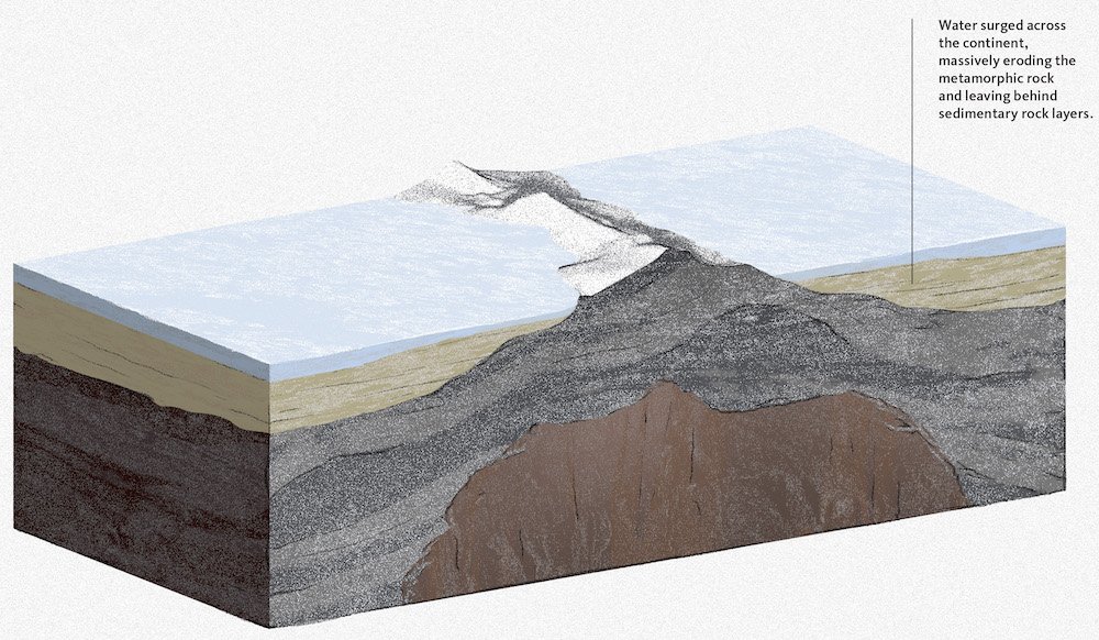
Fig. 3. Beginning of the Flood (Creation) / 1,450–300 Million Years Ago (Evolution)
Evolution
1,450–300 Million Years Ago
Over the next 900 or so million years, erosion slowly wore down those original bedrocks, exposing the tops of the granites.
Then between about 540 and 340 million years ago, shallow seas advanced and withdrew, covering much of the area with thousands of feet of gravel, sand, mud, and limey-ooze layers that hardened to sedimentary rocks.
Creation
Beginning of the Flood
The uplifting of the original supercontinent on the third day of creation massively eroded the emerging land surface to rapidly wear down the original bedrocks.
Then, about 4,250 years ago when the fountains of the great deep were broken up to initiate the global flood (Genesis 7:11), the original supercontinent broke apart. The resulting massive earthquakes created giant tsunamis that caused the flood (ocean) waters to surge across the continental plates.
The waters massively eroded the pre-flood rocks during the first days of the flood to expose the granites’ tops. Then rapidly over the next months a thick stack of sediment layers was deposited on the continental plates which were swiftly moving across the globe’s surface.
4 | A Temporary Uplift
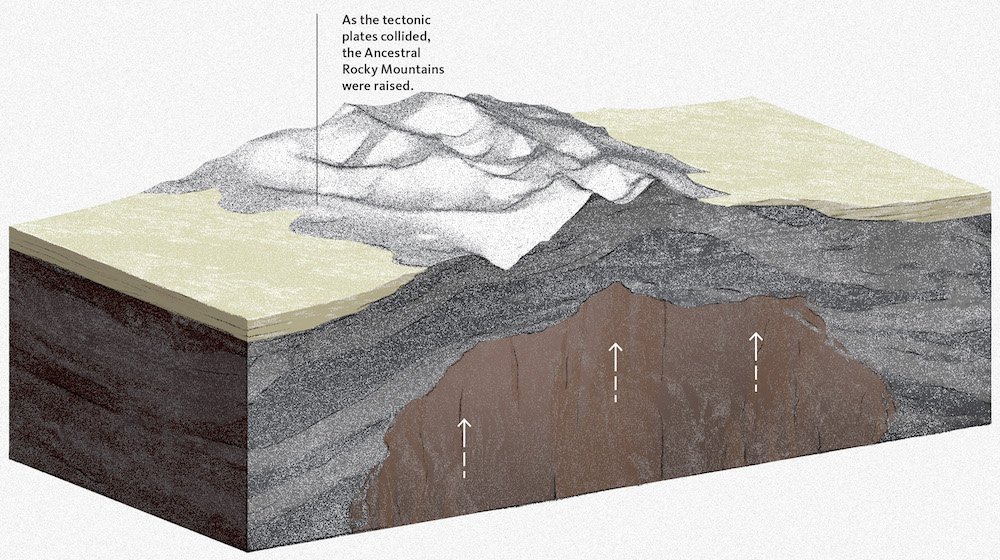
Fig. 4. Mid-Flood (Creation) / 300 Million Years Ago (Evolution)
Evolution
300 Million Years Ago
About 300 million years ago, these ancestral rocks were gradually uplifted to create what have been called the Ancestral Rockies, along what is now the Utah/Colorado border. At their maximum height, those mountains may have been about 2,000 feet (610 m) high.
Creation
Mid-Flood
Mid-flood, the African plate collided with the eastern side of the North American plate, buckling the layers there to form the Appalachians. Most of the continental plates thus amalgamated temporarily under the flood waters to form the Pangaea supercontinent. Over on the western side of the North American plate, the earth’s surface also rapidly uplifted at the same time to produce what are referred to as the Ancestral Rockies.
5 | A Watery Burial
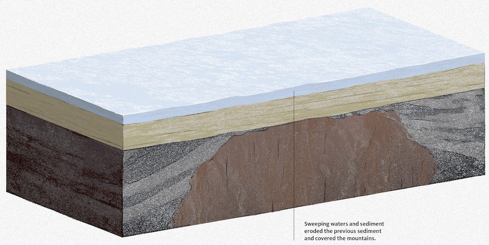
Fig. 5. Mid-Flood (Creation) / 250–100 Million Years Ago (Evolution)
Evolution
250–100 Million Years Ago
Increasing erosion and downcutting streams slowly stripped away the previously deposited marine sedimentary layers, along with some of the original bedrocks. By about 250 million years ago, all that remained of the Ancestral Rockies were low hills. The region flanking them was low and swampy. Amphibians, reptiles, and dinosaurs roamed the soggy terrain, leaving their footprints before their remains were buried and fossilized in the sediment layers that accumulated over the next 150 million years. Coal beds formed in the swamps, and coastal dunes moved along the shores of an inland sea.
By about 100 million years ago, the waters of an inland sea completely covered the region. Many feet of sand and clay accumulated on the shallow sea floor. By about 80 million years ago, 10,000–15,000 feet (3,000–4,500 m) of sediment had accumulated.
Creation
Mid-Flood
The pulsating flood waters rapidly eroded the previously deposited marine sedimentary layers and more of the original bedrocks. They then deposited more sediment layers as the waters continued to oscillate from the global tides and tsunamis generated by continued catastrophic plate movements. Some half-drowned animals left their footprints before they perished, while rafts of plant debris got buried to soon form coal beds. But now the tectonic focus had shifted to the western edge of the North American plate. Pangaea had begun to break apart, so the North American plate began moving westward, and the Farallon (Pacific Ocean floor) plate subducted (pushed) under it, generating volcanic eruptions.
6 | Tectonic Uplift
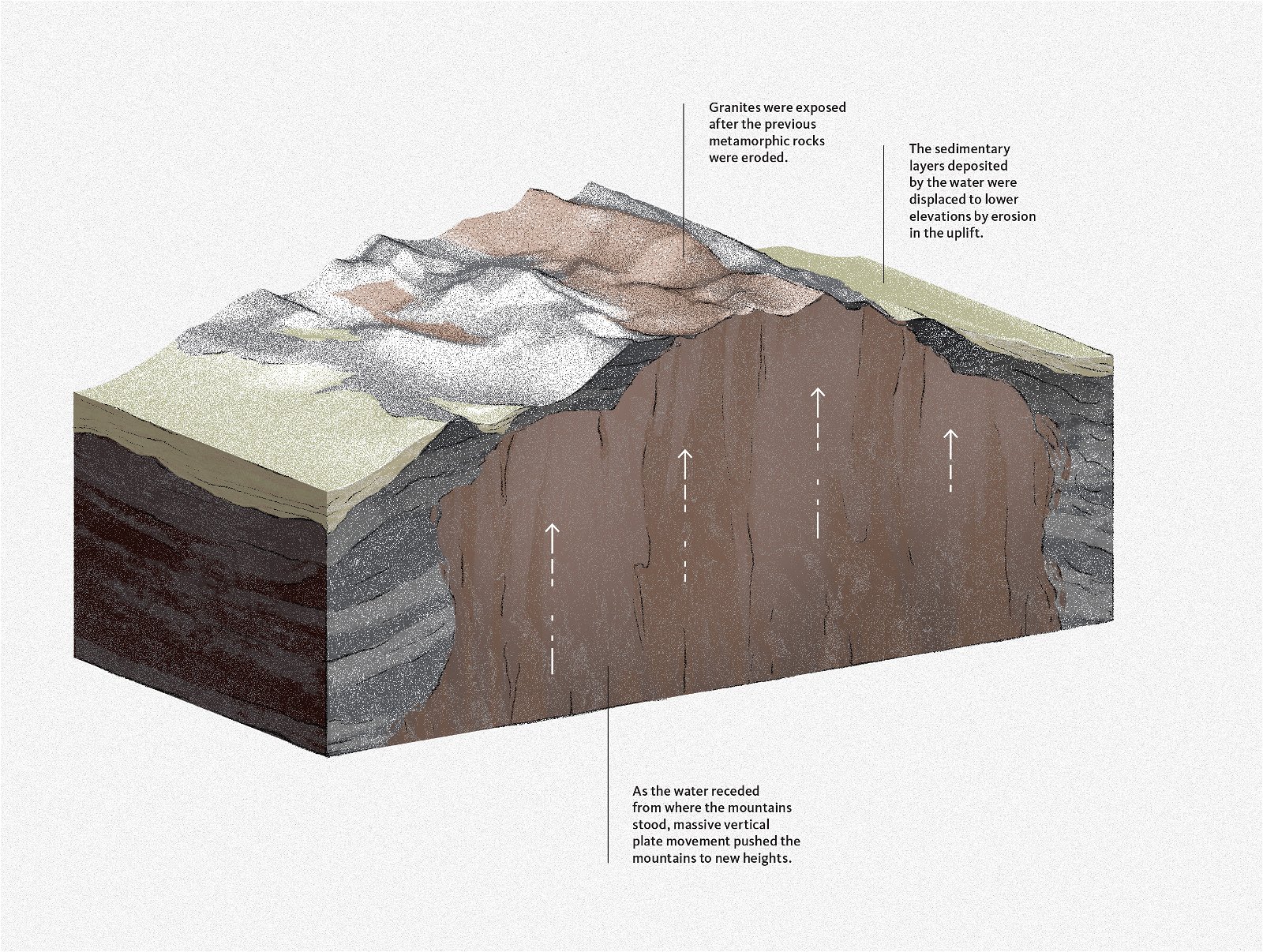
Fig. 6. Late-Flood (Creation) / 80–55 Million Years Ago (Evolution)
Evolution
80–55 Million Years Ago
About 80 million years ago, continuing for 25 million years, massive earth movements raised today’s Rocky Mountains in a major event called the Laramide orogeny. Large blocks were uplifted along deep fractures in the ancient crystalline foundational rocks. As a result, the Rockies became a high plateau, probably 20,000 ft (6,000 m) above sea level, with basins filled with water between the mountains.
Then, during and between episodes of volcanic activity, continual erosion lowered the plateau as it stripped away about 5,000 feet (~1,525 m) of sedimentary layers and also cut into those ancient crystalline foundational rocks.
Creation
Late-Flood
With the closing of the fountains (Genesis 8:2–3), the flood waters abated and the plates began to rapidly decelerate. The momentum of the subducting Farallon plate beneath the North American plate must have stalled. Without the energetic force to keep pushing it into the mantle, the Farallon plate’s subduction angle flattened, triggering the Laramide orogeny. At last, today’s Rocky Mountains pushed toward the sky as the flood ended.
7 | Settling in after an Ice Age
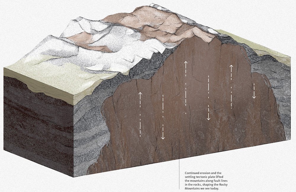
Fig. 7. Late-Flood to Today (Creation) / 35 Million Years Ago to Today (Evolution)
Evolution
35 Million Years Ago to Today
A series of uplifts occurred about 35 to 20 million years ago. Likely, as the earth’s crust rebalanced, a broad, regional up-arching raised the mountains as much as 4,000–6,000 feet (~1,200–1,800 m) primarily along old fault lines until the peaks reached their present dramatic heights.
Finally, glacial ice advanced and retreated, evidently many times, during the climatic fluctuations of the ice age, beginning apparently 1.8 million years ago. The ice finally receded fewer than 11,000 years ago, but left its mark by forming extensive glacial landforms, such as u-shaped valleys and cirques (bowl-shaped depressions carved into mountains by the erosion of glaciers).
Creation
Late-Flood to Today
The retreating flood waters massively eroded into the emerging Rockies as they continued to rise with adjustments to crustal balances and residual volcanic eruptions. Early in the post-flood era the peaks of the Rockies reached their current dramatic heights.
Soon after, the ocean waters that had been warmed by the volcanic waters during the flood began to generate super-storms that dumped heavy rains and then massively thick snow on the cold continental interiors and their mountains. This post-flood ice age completed the last stage of erosion, sculpting today’s Rockies.
Climate fluctuations have continued to the present. In the so-called little ice age from about AD 1550 to 1860, the glaciers high in the mountains advanced. Today they are receding again, and the processes of rockfalls and landslides continue to shape these mountains.
Why Are the Rockies So Far Inland?
One baffling mystery remains: Why are the Rockies over 600 miles (~1,000 km) inland when other mountain ranges around the globe are only 200–400 miles (~320–650 km) inland? Mountains usually form where tectonic plates collide or slide past each other. But the Rockies arose in the continent’s interior, hundreds of miles from a plate boundary.
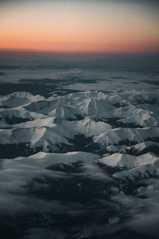
Photo by Colin Lloyd
Evolution
The continents’ current configuration and geology are attributed to very slow plate tectonics over billions of years. The original supercontinent broke apart and the plates (crustal fragments) drifted and then collided. In the collision zones, mountains were raised as a new supercontinent (Pangaea) formed. That supercontinent eventually broke apart to form today’s continents.
In that last cycle of drifting plates, for 270 million years, the effects of the collision of the Farallon (Pacific Ocean floor) plate with the North American plate were focused very near the edge of the North American plate boundary, far to the west of the Rocky Mountain region.
Recall that the Rockies were formed when the Farallon plate was being pushed under the North American plate. Normally, an oceanic plate sinks at a fairly steep angle. However, roughly 80 million years ago, the angle of the subducting Farallon plate significantly flattened, moving the focus of mountain-building much farther inland than is normally expected. Why that happened remains a mystery to evolutionists.
However, the shallow subduction angle of the Farallon plate greatly increased the friction with the thick continental mass of the North American plate directly above it. As a result, tremendous thrusts piled sheets of crust on top of each other, building the extraordinarily broad, high Rocky Mountains.
Creation
Far from requiring millions of years, the Rockies were formed in less than a year during the global flood cataclysm because of catastrophic plate tectonics, by which the plates moved at tens of feet (meters) per second (a fast walking pace).
However, as the flood ended, the plates decelerated rapidly. The momentum of the subducting Farallon plate beneath the North American plate stalled. Without the energetic force to keep pushing it into the mantle, the Farallon plate’s subduction angle flattened so that it got shoved well inland under western North America.
Then, as plate movement ground almost to a stop, the less dense rock of the Farallon plate, now well inland, caused it to rise and push up western North America with it, including the Rockies.
The mystery of why these processes occurred to raise the Rockies so far inland leaves room for dark ponderings of the forces the Creator unleashed to destroy a wicked preflood world. Yet from the flood’s cataclysmic forces came the majestic Rockies, clothed in magnificent forests with snow-capped rugged peaks—a testimony to the handiwork of a righteous yet gracious God. In the words of King David, “O Lord, our Lord, how majestic is your name in all the earth!
” (Psalm 8:1, 9).
holds a PhD in geology from the University of Sydney and has worked as a consultant research geologist in both Australia and America. Author of numerous scientific articles, Dr. Snelling is now director of research at Answers in Genesis–US.
Answers Magazine
October–December 2023
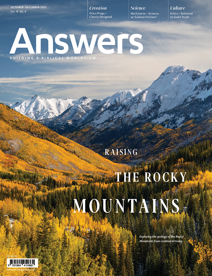
The Rocky Mountains are a majestic reminder of God’s past judgment and future promise.
Browse Issue

Support the creation/gospel message by donating or getting involved!

Answers in Genesis is an apologetics ministry, dedicated to helping Christians defend their faith and proclaim the good news of Jesus Christ.
- Customer Service 800.778.3390
- Available Monday–Friday | 9 AM–5 PM ET
- © 2026 Answers in Genesis