
A Puzzle of Mud & Bones
Putting together the pieces of this puzzle points to the cataclysmic events of the global flood.
I’ve always enjoyed putting together jigsaw puzzles. But as a boy, I quickly got bored with working the puzzles picture-side up, so I’d turn the pieces over and connect them face down.
My desire for a challenge has served me well as a scientist. Solving scientific puzzles can be a bit like putting together a jigsaw puzzle picture-side down—but even more difficult. At least a jigsaw puzzle has all the pieces you need in one handy box. In scientific investigations, we must collect the pieces for ourselves.
The Bible gives us a broad historical framework in the events of creation, the fall, the flood, Babel, and so on. We can think of these as the edge pieces of the puzzle that set the boundaries within which the inside pieces can be placed.
But the Bible doesn’t tell us exactly how these inside pieces fit together. Consider fossils, for example. We know that the fall of Adam introduced death to humans and animals (Genesis 1:29–30, 3:19, 9:3; Romans 5:12, 8:19–23; 1 Corinthians 15:21–22). From this we can infer that fossils must date from a time after the fall. But details such as which fossils formed before, during, and after the worldwide flood are not revealed in Scripture. We have no picture on a box to help us fit together those pieces. We just have to piece them together based on the scientific clues we gather.
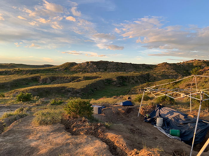
Since 1996, creation geologist Dr. Arthur Chadwick and his colleagues have been working on a scientific jigsaw puzzle in northeast Wyoming. For almost 25 years, they’ve gathered pieces of the puzzle and tried to work out how they fit together. But this is a jigsaw puzzle like no other. It’s a puzzle of mud and dinosaur bones.
Finding the Pieces
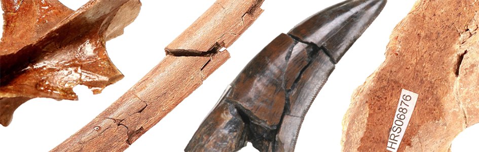
Paleontologists are finding some of the puzzle pieces on an active cattle ranch about 25 miles (40 km) southwest of Newcastle, Wyoming.1 After early excavations at this remote site uncovered many fossil specimens, paleontologists discovered that a major bed of dinosaur bones extends for more than one square kilometer.2 Since then an average of 1,000 fossils has been collected from the site every year, each building a clearer picture of the past.3
To study the bone bed, paleontologists use high-precision GPS technology to record the position and arrangement of each bone.4 They then use digital photographs to capture the bones when they are excavated. On computers, they combine the GPS coordinates with the photographs to reconstruct the bone bed as it would have appeared in the ground.5 These methods allow the scientists to capture the 3D relationships between the bones, information that would have been lost by more traditional methods of excavation.6
In Lance Formation dig sites like this one, research teams have discovered roughly 25,000 dinosaur bones and teeth.
Key Pieces of the Puzzle
In any jigsaw puzzle, several key pieces build up the picture, allowing more difficult pieces to be slotted in around them. Similarly, some key puzzle pieces have helped Dr. Chadwick and his team work out how the bone bed was formed.
A Huge Concentration of Bones
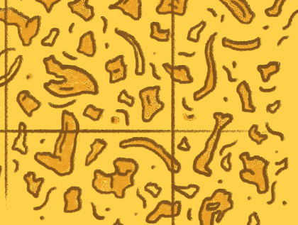
As of 2019, about 25,000 bones, bone fragments, and teeth have been excavated from seven quarries dug into the main bone bed7—but this is only a fraction of what remains in the ground. Each square meter (11 square feet) commonly holds 20–30 bones.8
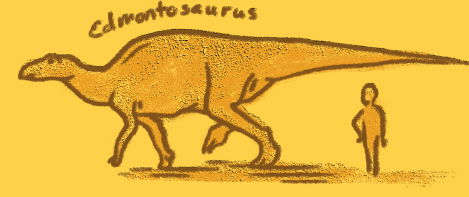
Most of the bones come from one type of dinosaur, a big plant-eater called Edmontosaurus.9 Paleontologists estimate that 25,000 of the dinosaurs are buried here, probably representing more than one herd.10 This is an immense find, especially considering that an adult Edmontosaurus was over 6,000 pounds (about 2,720 kg or 2.72 metric tons) and over 9 feet (3 meters) tall at the hips. (An average American bison, by comparison, weighed less than one-third as much as an Edmontosaurus.)
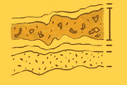
A Single Layer of Mudstone
The dinosaur bones are embedded in a single mudstone layer about 3 feet (1 m) thick.11 The mudstone is thickest in the northwest and gets thinner to the south.12 Above the bone bed is a layer of sandstone with features (such as climbing ripples, ripped-up mud pieces, and bone fragments) suggesting that it was deposited quickly.13
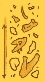
Bones Sorted Vertically by Size
The dinosaur bones are sorted by size, with the biggest bones (such as leg bones) at the bottom of the bed and the smallest bones (such as vertebrae and toe bones) at the top.14
Bones Mostly Disconnected
Occasionally two or three bones are found joined together, suggesting they were connected by soft tissues at the time of burial.15 However, most of the bones are disconnected, and no entire skeletons have been found.16
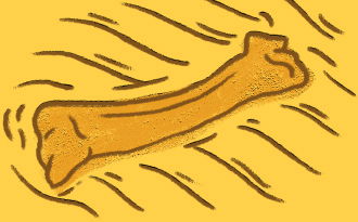
Bones in Pristine Condition
The bones show little evidence of exposure (such as weathering or sun bleaching) before burial and exhibit few signs of damage caused by being transported to where they were buried.17 However, some of the bones bear tooth marks, and others have been broken, perhaps by being trampled.18
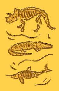
A Mix of Fossils from Different Environments
Though most of the fossils represent land animals (such as dinosaurs),19 some represent animals that lived in fresh or brackish water (such as crocodiles, turtles, and fish).20
Recording the Pieces
- First, the team details the fossil in a notebook.
- Next, the team digitally photographs the fossil.
- Using a GPS system, the team records a series of points across the bone’s surface to capture the fossil’s position and orientation.
- The team adds the GPS coordinates to a digital data bank and incorporates the photographs to map out a 3D reconstruction of the bone bed.
Putting the Pieces Together
So how did this bone bed form? Many geologists who are not young-earth creationists believe that dinosaur bone beds built up over long periods as migrating herds tried to cross major rivers.21 Each season, when some of the dinosaurs drowned, their carcasses were swept downstream to accumulate on a sandbar or a bend in the river.
Over time, as the river slowly switched positions, an extensive layer of dinosaur bones accumulated. Of course, this would have been a very slow process, requiring at least thousands of years.
Based on the puzzle pieces collected at the dig site, researchers in Wyoming suggest that, at least in this case, something is very wrong with that popular picture.
For starters, the bones are in one layer and sorted by size from the bottom upward, indicating that they were laid down at one time—not in multiple events over a long time.22 Also, the mudstone in which the bones are found represents a type of sediment not typically associated with fast-flowing rivers.23 And if the carcasses had accumulated one by one on a sandbar, we would expect to find complete or partial skeletons, not multitudes of disconnected bones.
Dr. Chadwick and his colleagues have proposed a different scenario, one that better fits the data.24 They suggest that tens of thousands of Edmontosaurus perished in some kind of catastrophe,25 after which their carcasses lay around just long enough to rot and be scavenged. This explains why most of the bones have fallen apart and show signs of damage.
Next, this putrid mass of dinosaur remains was picked up by a swift mudflow26 and swept southward into deep water where the bones came to rest suspended in the mud. This explains the type of sediment, the sorting of the bones by size, and the mixture of fossils found with the dinosaur bones.
Only Part of the Puzzle
But what could have caused these catastrophic events? For scientists like Dr. Chadwick who accept the Bible’s account of earth history in Genesis 1–11, Noah’s flood springs readily to mind. Catastrophic volcanic eruptions and earth movements early in the flood most likely killed these dinosaurs. Then their carcasses rotted for a while on an area of land temporarily exposed above water before the bones were transported to their final resting place.
Although ultimately it’s impossible to prove, the picture emerging at the dig site in Wyoming provides us with fascinating insights into the cataclysmic events that took place during the flood, confirming the authority of God’s Word.
Even after almost 25 years, the jigsaw puzzle in Wyoming is still far from complete. That’s what makes science so challenging and fun—we know there are always more puzzle pieces to be discovered if we’re willing to hunt for them.
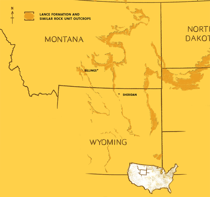
Flood Evidences in the Lance Formation
The dig site in Wyoming is only one piece of a much bigger geologic picture.
The bone bed belongs to the Lance Formation, a widespread rock unit that can be traced across much of Wyoming. (And to widen the picture even farther, similar formations spread across Montana, the Dakotas,27 Colorado,28 Saskatchewan,29 and Alberta.30)
The Lance Formation consists mostly of mudstone, sandstone, and some thin coal layers.31 Conventional geologists think that these sediments were deposited by freshwater streams meandering across a broad coastal plain about 66 million years ago.32 If this were true, it would have taken a long time to deposit the Lance Formation because it is almost a half mile thick.33
Based on many evidences, biblical creationists suggest that the Lance Formation was rapidly deposited during Noah’s flood.
Widespread Bone Beds
The bone bed that Dr. Chadwick’s team has been excavating has been the most studied. But the Lance Formation features other bone beds deposited by mudflows and other types of catastrophic processes.34
Widespread Sandstones
Some sandstone layers in the Lance Formation extend for tens of square miles and must have been deposited by water flowing quickly over broad areas, not confined to narrow streams.35
Massive Earthquake Layers
Throughout the formation, sandstone layers show signs of earthquake activity.36 In fact, the thickness of some of the disturbed layers indicates that the earthquakes must have been hundreds to thousands of times more powerful than any modern earthquakes. The seismic shocks would likely have shaken the whole continent.
Transported Fossils
Most of the fossils in the Lance Formation were transported by water before they were buried.37 Extensive beds of fossil clams, tightly packed with the shells closed and hinges intact, testify to rapid burial since the hinges usually come apart within days after death.38
Low Intensity of Burrowing
Most Lance Formation sediments show few signs of being churned up by animal burrows, suggesting they were deposited too quickly for burrowing animals to get to work.39
Volcanic Rock Fragments
Lance Formation sandstones are rich in rock fragments, many of them volcanic.40 These rocks likely came from major eruptions in southwest Montana.41
Iridium Layer
The top of the Lance Formation is marked by a clay layer containing shocked quartz grains and high levels of iridium (a dense, hard metal),42 probably from a catastrophic asteroid impact.
, researcher and lecturer with Biblical Creation
Trust in the UK, has an MSc in geoscience from University
College London, where he specialized in paleobiology. He is
a Fellow of the Geological Society of London and a member
of several other scientific societies. He is the author of
The New Creationism: Building Scientific Theories on a
Biblical Foundation.
Related Downloads
Dinosaur Pocket Guide (Excerpt)
PDF DownloadAnswers Magazine
March–April 2020

The Riot and the Dance films are reclaiming the nature documentary genre for the Creator’s glory.
Browse IssueFootnotes
- The project website is at http://dinosaurproject.swau.edu.
- A. V. Chadwick, L. Spencer, and L. E. Turner, “Taphonomic Windows into an Upper Cretaceous Edmontosaurus Bonebed,” Geological Society of America Abstracts with Programs 37, no. 7 (2005), p. 159.
- S. R. Weeks, Depositional Model of a Late Cretaceous Dinosaur Fossil Concentration, Lance Formation, MS Thesis, Loma Linda University, Loma Linda, California, 2016, p. 32. http://scholarsrepository.llu.edu/etd/405.
- The resolution of the real-time kinetic (RTK) GPS equipment used is 1 cm or less.
- L. E. Turner, A. V. Chadwick, and L. Spencer, “High Resolution GPS Mapping in a Vertebrate Taphonomic Quarry,” Geological Society of America Abstracts with Programs 32 (2000): A499; A. V. Chadwick, L. E. Turner, and L. Spencer, “Digital Modeling of a Taphonomic Quarry Using GIS Software,” Journal of Vertebrate Paleontology 22 (2002): 43A; A. V. Chadwick, L. E. Turner, and L. Spencer, “Recreating an Upper Cretaceous Dinosaur Assemblage with GIS Software,” Journal of Vertebrate Paleontology 23 (2003): 40A; A. V. Chadwick, L. E. Turner, and L. Spencer, “Five Years Experience Using GIS for Data Collection and Analysis in an Upper Cretaceous Dinosaur Quarry in the Lance Formation,” Journal of Vertebrate Paleontology 24 (Suppl. 3) (2004): 45A; L. E. Turner, A. V. Chadwick, and L. Spencer, “Using Rocket Science to Study Rock Science,” Journal of Vertebrate Paleontology 24 (Suppl. 3) (2004): 123A–124A; A. V. Chadwick, M. P. Silver, L. Turner, and J. Woods, “The Application of Digital Reconstruction Techniques in Taphonomy of an Upper Cretaceous Dinosaur Site in Eastern Wyoming,” Journal of Taphonomy 14, no.1 (2016): 1–14.
- The excavated bones are stored at the Drake Paleontology Museum on the campus of Southwestern Adventist University (SWAU), Keene, Texas. Data on the fossil specimens is freely accessible at the SWAU Online Fossil Museum: https://fossil.swau.edu. See J. A. Woods, “Development of an On-line Database with GIS Connections for Vertebrate and Other Fossils,” Geological Society of America Abstracts with Programs 37, no. 7 (2005): p. 44; J. A. Woods, “Development and Use of 3D Virtual Reality Movies in an Online Fossil Museum,” Geological Society of America Abstracts with Programs 39, no. 6 (2007): p. 64; J. A. Woods, and A. V. Chadwick, “Development and Implementation of an Efficient, Accessible Online Museum Site and Database with Open Access,” Geological Society of America Abstracts with Programs 46, no. 6, p. 701, 2014; J. A. Woods, “Digitization of Taphonomic Data in a Large Active Upper Cretaceous Dinosaur Site in Northeastern Wyoming,” Geological Society of America Abstracts with Programs 47, no. 7 (2015): p. 681.
- Dinosaur Excavation and Taphonomic Research Project, http://dinosaurproject.swau.edu/project/history/.
- Chadwick et al. 2004 (Ref. 5).
- The species is Edmontosaurus annectens. Most of the bones are from adult or sub-adult specimens with very few juveniles represented: Weeks, 2016, p. 82 (Ref. 3).
- A. V. Chadwick, L. Spencer, and L. E. Turner, “Preliminary Depositional Model for an Upper Cretaceous Edmontosaurus Bonebed,” Journal of Vertebrate Paleontology 26, no. 3 (2006): 49A.
- Almost all the bones are suspended in the mud and are not in direct contact with one another: Weeks, 2016, p. 61 (Ref. 3). This is a sign that the bones were transported by a mass flow process carried under the influence of gravity rather than solely by fluid flow: Weeks, 2016, p. 83 (Ref. 3).
- Chadwick et al. 2005 (Ref. 2). The mudstone varies from 0.5 m to 1.5 m thick: Weeks, 2016, p. 59 (Ref. 3).
- The contact between the bone bed and the overlying sandstone is sharp and flat. Evidences of rapid deposition in the sandstone include cross-bedding, climbing ripples, ripped-up mud pieces, bone fragments, and dewatering structures: L. Turner, B. Neufeld, A. Chadwick, and L. Spencer, “Ten Years Excavation at an Extensive Lancian Edmontosaurus Bonebed in Northeastern Wyoming,” Journal of Vertebrate Paleontology 30 (Suppl. 2) (2010):179A; Weeks, 2016, p. 59 (Ref. 3). Below the bone bed is a mudstone (at the north end) and a muddy sandstone (at the south end): Weeks, 2016, p. 59 (Ref. 3).
- Geologists call this “normal grading”: Chadwick et al., 2005 (Ref. 2); Weeks, 2016, p. 61 (Ref. 3). The sorting may be the result of different bone types having different densities: Chadwick et al. 2004 (Ref. 5).
- Chadwick et al., 2005 (Ref. 2); Weeks, 2016, p. 75 (Ref. 3).
- Ibid.
- Chadwick et al., 2006 (Ref. 10); Turner et al., 2010 (Ref. 13); Weeks, 2016, p. 82 (Ref. 3).
- Weeks, 2016, p. 82 (Ref. 3).
- Principally Edmontosaurus bones and teeth, but occasionally the remains of other dinosaurs, including Triceratops, Pachycephalosaurus, Nodosaurus, Tyrannosaurus, Nanotyrannus, and Troodon: Weeks, 2016, pp. 82, 102–103 (Ref. 3). There are also bones belonging to a dromaeosaur, probably Acheroraptor, though Weeks lists it as Dromaeosaurus.
- Teeth and small bones of crocodiles (e.g., Brachychampsa) and turtles have been found. There are also teeth and scales from rays (e.g., Rhombodus) and other fishes (e.g., Myledaphus): Weeks, 2016, pp. 102–103 (Ref. 3).
- R. R. Rogers, D. A. Eberth, and A. R. Fiorillo (eds.), Bonebeds: Genesis, Analysis, and Paleobiological Significance, (Chicago: The University of Chicago Press, 2007), pp.13–14.
- If the bones had been deposited in multiple, successive events, all types of bones would be represented at all levels through the layer from bottom to top. But, in fact, different types of bones occur at different levels through the layer. This is evidence that the layer represents a single event in which disarticulated bones have been sorted by size and/or density. Weeks, 2016, pp. 82–83 (Ref. 3).
- Mudstone is a fine-grained sediment. Fast-flowing rivers tend to deposit coarse-grained sediments, such as sands and gravels.
- Weeks, 2016, pp. 81–87 (Ref. 3). See also L. Spencer, L. E. Turner, and A. V. Chadwick, “A Remarkable Vertebrate Assemblage from the Lance Formation, Niobrara County, Wyoming,” Geological Society of America Abstracts with Programs 33, no. 6 (2001): 1172; Chadwick et al., 2006 (Ref. 10); Turner et al., 2010 (Ref. 13).
- Perhaps volcanic in nature: Turner et al., 2010 (Ref. 13).
- Most likely of a type called a debris flow, in which the suspended particles (in this case, mud and bones) flowed as a single mass along with the suspending fluid. The mudflow may have been triggered by earthquake activity: Weeks, 2016, p. 86 (Ref. 3). Also S. R. Weeks, A. V. Chadwick, and L. R. Brand, “Large Dinosaur Bonebed Deposited as Debris Flow: Lance Formation Niobrara County, Wyoming,” Geological Society of America Abstracts with Programs 47, no. 7 (2015): 566.
- The Hell Creek Formation: K. R. Johnson, D. J. Nichols, and J. H. Hartman, “Hell Creek Formation: A 2001 Synthesis,” in J. H. Hartman, K. R. Johnson, and D. J. Nichols (eds.), The Hell Creek Formation and the Cretaceous-Tertiary Boundary in the Northern Great Plains: An Integrated Continental Record of the End of the Cretaceous, Geological Society of America Special Paper 361, Boulder, Colorado, 2002, pp. 503–510.
- The Laramie Formation: E. R. Lloyd, and C. J. Hares, “The Cannonball Marine Member of the Lance Formation of North and South Dakota and its Bearing on the Lance-Laramie Problem,” Journal of Geology 23, no. 6 (1915): pp. 523–547.
- The Frenchman Formation: W. O. Kupsch, “Frenchman Formation of Eastern Cypress Hills, Saskatchewan, Canada,” Geological Society of America Bulletin 68 (1957): 413–420.
- The Lower Part of the Scollard Formation: D. A. Eberth, and S. C. O’Connell, “Notes on Changing Paleoenvironments Across the Cretaceous-Tertiary Boundary (Scollard Formation) in the Red Deer River Valley of Southern Alberta,” Bulletin of Canadian Petroleum Geology 43, no. 1 (1995): pp. 44–53.
- C. W. Connor, The Lance Formation Petrography and Stratigraphy, Powder River Basin and Nearby Basins, Wyoming and Montana, US Geological Survey Bulletin 1917-1 (1992), pp. I1–I17.
- Wyoming Geological Association, “Geological History of the Powder River Basin,” American Association of Petroleum Geologists Bulletin 49, no. 11 (1965): 1893–1907.
- Total thickness in the type area is estimated at 730 meters (2,400 feet): See K. Wise, “Megaseismites in the Type Area of the Lance Formation (Maastrichtian, Cretaceous; Niobrara County, Wyoming),” Geological Society of America Abstracts with Programs 50, no. 6 (2018): doi: 10.1130/abs/2018AM-323823.
- For example, see M. A. McLain, A. V. Chadwick, L. R. Brand, and D. Nelsen, D., “Solving Taphonomic Jigsaw Puzzles: Insight into the Complex Depositional History of a Lance Formation (Maastrichtian) Dinosaur Bonebed,” Geological Society of America Abstracts with Programs 46, no. 6, p. 330, 2014; M. A. McLain, Taphonomy of a Lance Formation (Maastrichtian, WY) Dinosaur Bonebed with a Focus on Tooth Traces, PhD Thesis, Loma Linda University, Loma Linda, California, 2016, http://scholarsrepository.llu.edu/etd/410; K. Snyder, M. A. McLain, and A. V. Chadwick, A.V., “Discovery of a Unique Multitaxic Dinosaur Bonebed from the Lance Formation (Maastrichtian) of Wyoming,” Geological Society of America Abstracts with Programs 49, no. 6 (2017): doi: 10.1130/abs/2017AM-304322; K. Snyder, M. A. McLain, and A. V. Chadwick, “Four Overlapping Dinosaurs in Three Orientations: A Taphonomic Puzzle from the Lance Formation of Wyoming,” Geological Society of America Abstracts with Programs 50, no. 3 (2018): doi: 10.1130/abs/2018SE-312337.
- Kurt Wise has recently mapped sandstone layers in the Lance Formation that can be traced at least 10 kilometers (6 miles) in an east-west direction and 16 kilometers (10 miles) in a north-south direction. Some of these units display cross-bedding 0.9 meters (three feet) high. From these observations it can be inferred that they were deposited by water at least nine meters (30 feet) deep, flowing at velocities of one meter per second (3.28 feet per second) across an area of 155 square kilometers (60 square miles): K. Wise, “Updates on Creation Research,” video lecture, October 2017. https://tinyurl.com/y8txqd2j
- Geologists call these earthquake-disturbed layers seismites. A two-meter-thick seismite was first mapped at the Wyoming site in 2011: S. R. Weeks, and A. V. Chadwick, “A Prominent Seismite in the Upper Cretaceous Lance Formation in Northeastern Wyoming as a Stratigraphic Marker,” Geological Society of America Abstracts with Programs 43, no. 5, p. 1, 2011; S. R. Weeks, and A. V. Chadwick, “A Regionally Extensive Lancian Seismite Serves as a Time Synchronous Stratigraphic Marker for Mapping Dinosaur Bonebeds in Northeastern Wyoming,” Journal of Vertebrate Paleontology 32 (Suppl. 1) (2012): 191. Since then, 43 seismites with thicknesses greater than 0.9 meters (three feet) have been identified throughout the Lance Formation—averaging one every 12–15 meters (40–50 feet): Wise, 2018 (Ref. 33).
- Weeks, 2016, p. 82 (Ref. 3).
- The clams belong to a family of freshwater bivalves called the Unionidae, probably the genus Unio. Weeks, 2016, p. 103 (Ref. 3). The shells of these clams have weak hinges that typically come apart within days of death, so tightly closed fossil shells are evidence that the clams were buried while still alive or very soon after they died. See R. H. Cummins, “Taphonomic Processes in Modern Freshwater Molluscan Death Assemblages: Implications for the Freshwater Fossil Record,” Palaeogeography, Palaeoclimatology, Palaeoecology 108 (1994): 55–73.
- Weeks, 2016, pp. 4, 82 (Ref. 3).
- Microscope studies show that rock fragments comprise an average of 34% of the sandstone grains in the southern part of the Powder River Basin and 57% in the northern part of the basin: Connor, 1992, p. I1 (Ref. 31).
- Connor, 1992, pp. I14–I15 (Ref. 31).
- B. F. Bohor, D. M. Triplehorn, D. J. Nichols, and H. T. Millard Jr., “Dinosaurs, Spherules, and the ‘Magic’ Layer: A New K-T Boundary Clay Site in Wyoming,” Geology 15 (1987): 896–899.
Support the creation/gospel message by donating or getting involved!

Answers in Genesis is an apologetics ministry, dedicated to helping Christians defend their faith and proclaim the good news of Jesus Christ.
- Customer Service 800.778.3390
- Available Monday–Friday | 9 AM–5 PM ET
- © 2026 Answers in Genesis