


Evolutionists Are Wrong: Here’s The Truth About the Mediterranean Salt Deposits
In 1971, those who drilled into the floor of the Mediterranean Sea during the Deep Sea Drilling Project (DSDP) discovered so-called evaporite deposits between the sediment layers.1 Such salt deposits are made up of halite (sodium chloride [NaCl] or common table salt), gypsum and anhydrite (two forms of calcium sulfate [CaSO4]), calcite (calcium carbonate [CaCO3]), and dolomite (calcium magnesium carbonate [CaMg(CO3)2]. They are believed to have come about by the evaporation of salty seawater, hence the name evaporites. Since the evaporation of seawater is a slow process, evolutionary geologists conclude that it must have taken hundreds of thousands of years to accumulate layers of these salts through this evaporation.
Thus, they proposed that, about 5.6 million years ago, the Mediterranean Sea became disconnected from the Atlantic Ocean due to the uplift of the narrow Strait of Gibraltar, which choked off tidal replenishment of the Mediterranean’s waters.2 This rebalancing uplift was due to the slow northward movement of the African tectonic plate being pushed beneath the Eurasian plate. Evolutionary geologists claim that as a consequence, the waters of the Mediterranean Sea slowly evaporated over hundreds of thousands of years, even though intermittent rains added some water to the sea via rivers and washed sediments across its floor. This became known as the Messinian Salinity Crisis because it occurred during the Messinian stage (supposedly about 7.25 to 5.33 million years ago), the uppermost stage of the Miocene epoch of the uniformitarian (conventional) geologic timescale.
Then, as the story goes, the Atlantic Ocean waters finally found a way through the present-day Strait of Gibraltar and rapidly refilled the Mediterranean in a somewhat catastrophic mega flood about 5.33 million years ago.3 This event has been called the Zanclean flood because it occurred at the beginning of the Zanclean stage (supposedly about 5.33 to 3.6 million years ago), the lowermost stage of the Pliocene epoch in the uniformitarian (conventional) geologic timescale. According to Garcia-Castellanos et al.,
Water flow and incision in the early stages of flooding imply discharges of about 108 [100 million] m3 [about 3.53 billion cubic feet] s-1 [per second] (three orders of magnitude larger than the present Amazon River) and incision rates above 0.4 m [about 1.3 feet] per day. Although the flood started at low water discharges that may have lasted for up to several thousand years, our results suggest that 90 per cent of the water was transferred in a short period ranging from a few months to two years. This extremely abrupt flood may have involved peak rates of sea level rise in the Mediterranean of more than ten metres [~33 feet] per day.4
So what are we to make of these claims? Was there a Messinian Salinity Crisis that produced massive salt deposits in the floor of the Mediterranean Sea when the water evaporated? And was it followed by a Zanclean flood when the Mediterranean Sea refilled very rapidly? If so, how and where do these “events” fit within the biblical framework and chronology for the earth’s history?
The Messinian Evaporites
There is no question about the existence of these salt deposits between the sediment layers in the floor of the Mediterranean Sea. They were located within many boreholes and oil wells drilled into the Mediterranean’s floor (Fig. 1).5 In total, some 1,600 m [~5,250 feet] of layered salt and mud deposits are said to have formed in about 700,000 years.6
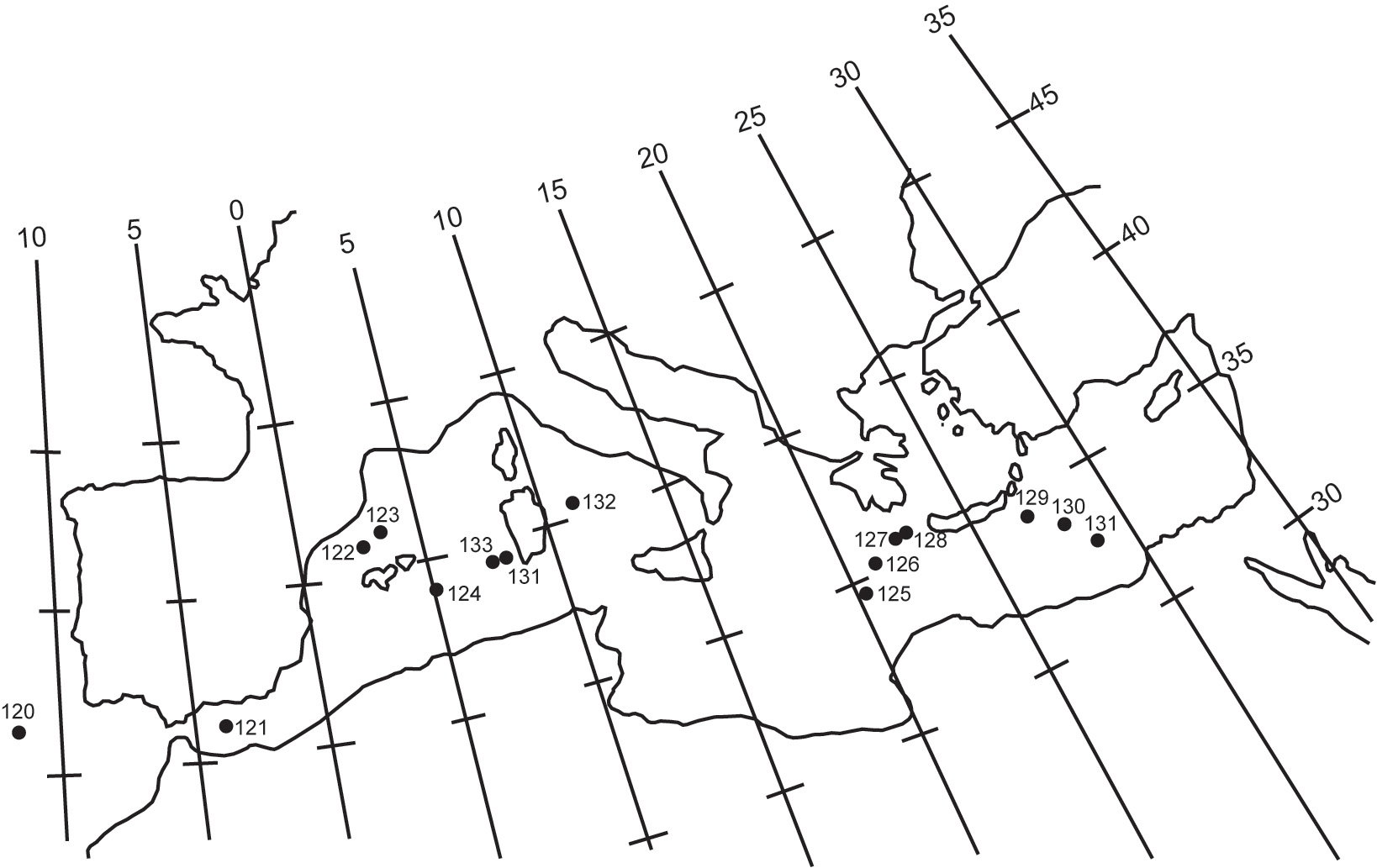
Fig. 1. Locations of the drill holes in the Mediterranean Sea on Leg XIII of the Deep Sea Drilling Project (after Hsü et al., Fig. 2).
When these salt deposits were discovered, their origin was an enigma. Conventional (uniformitarian) geologists suggested three different formation models:
- Evaporation of a deep-water Mediterranean basin (the “deep-water, deep-basin model”)
- Evaporation of a shallow-water Mediterranean basin (the “shallow-water, shallow-basin model”)
- Desiccation (drying out) of a deep Mediterranean basin.7
In the first two models, the Mediterranean basin would have received a constant inflow from the Atlantic, maintaining its brine level. However, in the third model (which became preferred), the Mediterranean basin would have been isolated from the Atlantic so that salt deposits thousands of meters below the Atlantic sea level formed by evaporating brines in playas or salt lakes on the basin’s floor.
Do any of these models explain the evidence? Let’s take a closer look at exactly what was found.
First, an earlier geophysical survey of the Mediterranean Sea found a strong acoustic reflector that had a basin-wide distribution.8 The subsequent DSDP drilling confirmed that the strong acoustic reflector correlated with the top of the Messinian evaporites.9 Furthermore, the surface of that reflector more or less matched the contours of the intricate submarine topography, indicating that the Mediterranean basin had already been formed at the time of the Messinian evaporites’ deposition with a configuration and topography similar to that of the present Mediterranean.
Second, the so-called evaporite deposits sit on layers of deep-marine pelagic (open ocean) sediments: lime muds containing tiny, shelled foraminifera fossils. Similarly, the strata directly overlying the Messinian evaporites are also deep-marine pelagic sediments that contain fossils of tiny crustaceans called ostracods, which only live in ocean bottoms below 1,000 m [about 3,280 feet]. Furthermore, the Messinian evaporites such as halite and anhydrite are interlayered with pelagic (open ocean) oozes containing foraminifera fossils in numerous locations throughout the Mediterranean basin, or with deep-water turbidites.10 Thus, the occurrence of deep-marine sediments below, above, and within the Messinian evaporite layers conclusively indicates that the Mediterranean was a deep basin with a deep-marine environment of deposition before, throughout, and after this Miocene time frame.
Third, in stark contrast to the deep-water, marine sediment layers below, above, and interbedded throughout, conventional geologists have, based on mineralogical, sedimentological, and geochemical data, emphatically interpreted the Messinian evaporites as not having been precipitated from a deep brine pool, but rather having been chiefly formed in shallow waters or subaerially.11 Indeed, the occurrence of anhydrite as the dominant sulfate mineral in the Messinian evaporites is a strong argument against a deep-water origin because, on its own, anhydrite only precipitates above 58°C [about 136°F], or at about 20°C [68°F] from brines saturated with sodium chloride (halite).12 However, the anhydrite in the Messinian evaporites is found either in nodules similar to those only found today in hot, arid, shallow coastal flats called sabkhas where temperatures reach at least 35°C [95°F], or interlaminated with dolomite (calcium magnesium carbonate [CaMg(CO3)2]) (Fig. 2).
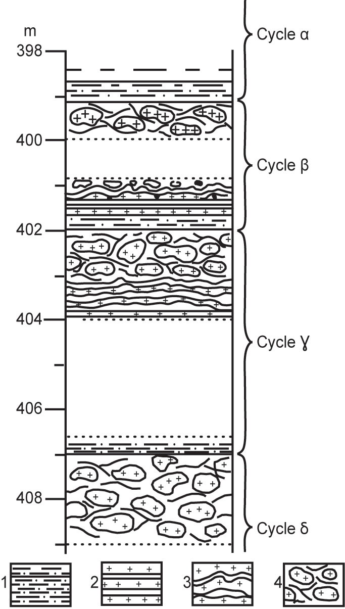
Fig. 2. Schematic diagram of depositional cycles in DSDP hole 124, located in the western Mediterranean basin (see Fig. 1) (after Hsü et al., Fig. 4). Legend: 1 = laminated carbonates; 2 = interlaminated dolomite and anhydrite; 3 = stromatolitic deposits; 4 = nodular anhydrite; blank = pelagic oozes.
Dolomite is ubiquitous in carbonate layers in the geologic record but only precipitates above about 50°C [122°F]; this has been known as the “dolomite problem” for over 200 years.13 So its dominant presence in the Messinian evaporites is also problematic. Furthermore, the dolomites also contain marine microfossils. Yet, within the sequence of evaporite layers are stromatolitic deposits (Fig. 2). Stromatolites are sediment layers deposited by tides in very shallow saline waters, cemented by mats of algae that grow over the sediment surfaces.
Fourth, these salt deposits are not evenly distributed across the Mediterranean basin, although there are significant distribution patterns. Hsü et al. suggested the pattern of salt deposits in the western Mediterranean basin (Fig. 3) was similar to the salt deposition pattern in a hypothetical partially restricted basin. Precipitation of salts due to the evaporation of brines in a playa or sabkha would leave concentric zones like a bull’s-eye. However, a restricted deep-marine basin with an opening at one end would have less soluble salt deposited proximal to the opening and more soluble near the distal and deepest end, similar to the pattern in Fig. 3. However, that distribution and thickness are not uniform but variable throughout the entire Mediterranean basin and adjacent onshore coastal margins. Whereas the evaporite’s sequence is up to 2,000 m [~6,560 feet] thick in the western Mediterranean basin, it is 3,000–4,000 m [~9,840–13,120 feet] thick in a few small areas in the eastern Mediterranean basin, with individual halite beds up to 150 m [~490 feet] thick.14 Indeed, it has been estimated that there are 820,000–930,000 cubic km [~196,728–223,118 cubic miles] of late Messinian salt, and a total of up to 1,200,000 cubic km [~287,895 cubic miles] of salt plus associated sediment tied up in the deep Mediterranean basins.15
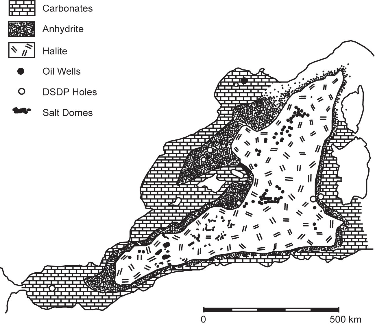
Fig. 3. Probable distribution of evaporites in the western Mediterranean basin as depicted by Hsü et al. (after their Fig. 9).
The Preferred Deep Mediterranean Basin Desiccation Model
Despite some of the conundrums discussed above, especially the deep-marine pelagic sediments interbedded with anhydrite and dolomite layers that could only have precipitated at high temperatures, the preferred uniformitarian (slow-and-gradual) model for the formation of these salt deposits remains the drying out (evaporation) of the deep Mediterranean basin waters as a result of Atlantic water inflows being cut off.
Yet Hsü et al. recognized the dilemma. The annual loss of water by evaporation from the Mediterranean Sea is about 4,700 km3 [about 19,590 cubic miles], while the annual precipitation is 1,200 km3 [just over 5,000 cubic miles] and the annual volume of water delivered by river influx is 200 km3 [about 834 cubic miles].16 Thus, the net loss of water is about 3,300 km3 [13,755 cubic miles] per year. So if the Strait of Gibraltar were closed, the present Mediterranean could be evaporated dry within about 1,000 years. However, a halite layer precipitated from one basinful of Mediterranean water (averaging 1,500 m [~4,920 feet] deep) would be only about 20 m [~66 feet] thick (in contrast to up to 150 m [~490 feet] thick deposits that have been found, as noted above). Furthermore, even if the salt deposition was restricted to one-third of the basin, the resulting halite layer would still be only 60 m [~197 feet] thick. Yet the seismic record shows that the salt deposits under the Mediterranean are generally 2–3 km [~6,560–9,840 feet] thick.17 Thus, repeated marine inflows from the Atlantic have been postulated because the freshwater influx from the rivers could not supply all the salts.
It has been proposed that the Mediterranean basin dried up and refilled repeatedly during the few million years of the Messinian stage of the uppermost Miocene epoch, known as the Messinian Salinity Crisis. Evolutionists call this a crisis due to the supposed environmental severity of the repeated drying and refilling by normal processes that we see happening today. Furthermore, the refilling of the basin would not have been instantaneous. Each marine inflow from the Atlantic into the Mediterranean only brought enough salt to deposit a few hundred meters of halite in basinal areas. There were likely eight or ten marine infillings that can be correlated with the interbeds of marine muds in the upper Miocene evaporite sequence in Sicily, which would seem sufficient to account for all the salt deposits under the floor of the Mediterranean Sea.18
To explain these eight to ten marine infillings of the Mediterranean basin during the Messinian Salinity Crisis, it is postulated that reduced connectivity between the Atlantic and the Mediterranean resulted from tectonic uplift of the Gibraltar arc seaway and global sea-level changes, both of which would have controlled the inflow of water.19 In that scenario, the seaway erosion of the Gibraltar arc caused by the inflow of Atlantic water would have sustained a shallow connection between the Atlantic and the Mediterranean by counteracting the tectonic uplift.
However, it is still not resolved whether this Messinian Salinity Crisis was triggered by a major (≥1 km [≥ ~3,280 feet]) drawdown of the water level in the Mediterranean due to its evaporation, or if the Messinian evaporite sequence was deposited in a brine-filled Mediterranean basin still connected to the Atlantic. Ongoing analyses of the evidence now suggest there were two primary phases of accumulation of the Mediterranean salt layers. The first phase is said to have lasted ~35,000 years, during which halite deposition occurred only in the eastern Mediterranean basin due to the restriction of outflows of Mediterranean water to the Atlantic, which ensured the Mediterranean basin was continuously filled with brine. During the second phase, halite accumulation is postulated to have occurred across the entire Mediterranean basin, driven by a “rapid” (<10,000 years) drawdown due to evaporation causing the water level to drop some 1.7–2.1 km [~5,575–6,890 feet] in the eastern Mediterranean basin and by ~0.85 km [~2,790 feet] in the western Mediterranean basin. During this latter extreme evaporation phase, the eastern Mediterranean basin would have lost up to 83% of its water volume, and large parts of its margins would have dried out, while its deeper sub-basins remained filled with a brine depth of >1 km [≥ ~3,280 feet].20
The main evidence for a sea-level drop of ≥1 km [≥ ~3,280 feet] in the Mediterranean basin “is the excavation of canyons by the rivers flowing to the [partly] empty sea” during the Messinian Salinity Crisis.21 The canyon offshore of the Nile River delta is up to 2,500 m [~8,200 feet] deep, while the canyon at the mouth of the Rhone River is about 1,000 m [~3,280 feet] deep.22
However, there have been recent challenges to the extreme sea level drop estimated at >2 km [~6,560 feet] in the deep Mediterranean basin in the desiccation model during the Messinian Salinity Crisis, postulated more than 50 years ago by Ryan et al. and Hsü et al., which has subsequently dominated conventional literature. For example, the Mediterranean’s sea-level drop during the Messinian Salinity Crisis has been reestimated by recalculating both the topography of the Nile canyon and the vertical position of the coastline during the Messinian event by removing the effects of post-Messinian sediments and accounting for flexural vertical-balancing earth movements (isostasy) and compaction.23 Thus, “the original depth of the geomorphological base level of the Nile River” was estimated to have been only ~600 m [~1,968 feet] below the present sea level, implying the drop in the Mediterranean’s sea level during the Messinian Salinity Crisis would have been only ~600 m [~1,968 feet], “2–4 times smaller than previously estimated from the Nile canyon.” Furthermore, this implies that the Messinian salt deposits instead “precipitated under 1–3 km [~3,280–9,840 feet] deep waters.” That conclusion is seemingly incompatible with the deep Mediterranean basin desiccation model (>2 km [~6,560 feet] drawdown).24
So while there is agreement among uniformitarian geoscientists that these Messinian salt deposits accumulated over hundreds of thousands of years, there is a continuing debate about how deep or shallow the waters of the Mediterranean Sea were during the Messinian Salinity Crisis. Deep waters would have required the salts to precipitate from brines, whereas shallow waters would have implied that the salts were precipitated by evaporation. The dilemma is exacerbated by the marine fossiliferous sediments interbedded between the salt layers and the high temperatures required for both anhydrite and dolomite to form. Ongoing attempts to model the postulated drawdown of the Mediterranean Sea’s water level have used a landscape evolution model constrained by paleoclimate parameters, sediment budgets, and retrogressive river incision,25 but the dilemmas (and more) remain unresolved.
What About the Zanclean Flood?
There is no doubt that the deposition of the salt layers came to an abrupt end because they are directly overlain by deep-marine pelagic sediments that contain fossils of tiny crustaceans called ostracods, which only live in ocean bottoms below 1,000 m [about 3,280 feet]. However, the nature and development of this flood remain poorly constrained.26 Borehole and seismic data show incisions over 250 m [~820 feet] deep on both sides of the Strait of Gibraltar that had previously been attributed to fluvial erosion during the desiccation of the Messinian Salinity Crisis.27 “These profiles provide evidence for the geometry of this incision and its continuity across the Gibraltar Strait along at least 200 km [~124 miles].”28 Furthermore, “a similar eastward-oriented incision is observed further to the east, in the Alborán [Mediterranean] side of the strait.”29 This totals an incision “nearly 390 km [~242 miles] long and several hundred meters deep [as an] erosion channel extending from the Gulf of Cádiz (Atlantic Ocean) to the Algerian Basin (Western Mediterranean).”30
Furthermore,
“The geometry of the incision has a U-shaped cross section with a size varying from 650 m [~2,132 feet] depth by 11 km [~6.8 miles] width near the strait to less than 300 m [~984 feet] depth per 6 km [~3.7 miles] in different branches of the channel further to the east. . . . The U-shape of this incision and its presence at both the eastern and western sides of the drainage divide cast doubt on its formation by subaerial fluvial erosion (typically producing V-shaped valleys).”31
By adopting an incision model validated in mountain rivers, “the continuity of this 390-km-long channel across the strait and . . . its morphology” are best explained “as the result of erosion by the flooding waters.”32 Such modeling of the resulting catastrophic flooding envisaged peak water discharges of about 100 million m3 [about 3.53 billion cubic feet] per second (three orders of magnitude larger than the present Amazon River) and incision rates above 0.4 m [about 1.3 feet] per day. “Although the flood started at low water discharges that may have lasted for up to several thousand years,” this modeling suggested that 90% of the water was discharged within a few months to two years, and the peak rate of sea-level rise in the Mediterranean was more than 10 meters [~33 feet] per day.33 Furthermore, rather than being like a waterfall, the geophysical data indicated the water flowed down a huge ramp, several kilometers wide, from the Atlantic to the Mediterranean with a slope of 1% to 4%, similar to the slope of the present seafloor eastward from the Strait of Gibraltar. And erosional retreat caused by this Zanclean mega flood “shifted the sill 30–80 km [~18.6-49.7 miles] westwards from its Messinian location at the Strait of Gibraltar and shaped the incision channel and the bulk of the strait morphology as we see them today.”34
While it has been concluded that further research is needed, ad hoc hydrodynamic modeling has explored “two predictions of the Zanclean outburst flood hypothesis,” namely, “the formation of similar erosion features at sills communicating sub-basins within the Mediterranean Sea, specifically at the Sicily Sill,” and “the accumulation of the eroded materials as megaflood deposits in areas of low flow energy.”35 Recent data show a 6 km wide [~3.7 miles] amphitheater-shaped canyon called the Noto Canyon “preserved at the Malta Escarpment that may represent the erosional expression of the Zanclean flood after filling the western Mediterranean and spilling into the eastern basin. Next to that canyon, a ~1600 km3 [~384 cubic miles] accumulation of chaotic . . . sediment has been found,” compatible in age and consistency with mega flood deposits.36
How and Where Do These “Events” Fit Within the Biblical Framework of Earth History?
Having established that there are thick salt deposits interlayered with fossiliferous marine sediments in the Mediterranean basin collectively known as the Messinian, and that the salt deposition ended abruptly with a possible Zanclean flooding event, how and where does all this fit within the biblical framework of earth history? Of course, we need not be constrained by the conventional dating of these Messinian salt deposits and the overlying marine sediments abruptly deposited on top of them. Conventional dating methods are based on flawed assumptions, primarily the assumption that the radioactive decay systems employed in the methods have been constant in the past at today’s measured slow decay rates. Furthermore, that same uniformitarian assumption, namely that the present is the key to the past, cannot explain any Zanclean mega flood, as we have never witnessed such a catastrophic event today. So we are free to view the evidence through the lens of the God-witnessed testimony of the biblical history of the earth and its timeline.
We are free to view the evidence through the lens of the God-witnessed testimony of the biblical history of the earth and its timeline.
The Messinian Salt Beds37
A crucial question is whether the sequence of salt beds matches the sequence of salts produced by evaporation of seawater. Actually, there are discrepancies between the Messinian sequence and the sequence observed in laboratory experiments. The sequence of minerals that precipitate when ocean water is evaporated in the laboratory was first demonstrated by Usiglio in 1848.38 Minor quantities of carbonate minerals begin to form when the original volume of seawater is reduced by evaporation to about one half. Then gypsum (calcium sulfate) appears when the original volume has been reduced to about 20%, and halite (sodium chloride) forms when the water volume reaches approximately 10% of the original volume. Magnesium and potassium salts are then deposited when less than about 5% of the original volume of seawater remains.
However, the proportion of calcium sulfate (gypsum and anhydrite) is generally greater, and the proportion of sodium-magnesium sulfates is less in natural deposits than observed in laboratory experiments.39 Furthermore, the thickest sequences of salt deposits in the Mediterranean basin begin with more than 500 meters [~1,640 feet] thickness of massive halite, and they contain anhydrite, not gypsum, and dolomite (magnesium-calcium carbonate), not calcite (calcium carbonate), but no potassium salts.40 If, as the seawater was evaporated, new seawater was constantly added to the depositional basin to maintain the original volume, then the brine would have become concentrated to the point of only precipitating halite, as found in the massive beds in the western Mediterranean basin.41
So how then do creation geologists explain layered salt deposits? Some have proposed that salt deposits were intruded as magmas at a temperature of 800°C [1,472°F],42 even interfingering with sediments due to concurrent watery sediment deposition.43 However, if the Messinian salt layers were the result of salt magmas, they would have to intrude so as to be interlayered between deep-marine fossiliferous muds, with the different salts having separated into their respective individual salt layers. Or the interlayering had to be due to intrusion of successive salt magmas, each composed of each individual salt. What these salt magma proponents have not explained is how the magmas would have intruded at 800°C [1,472°F] without that contact metamorphosing (“cooking and baking”) the interbedded sediment layers and the fossils they contain.
In any case, evaporation of seawater is not the only means by which a highly concentrated brine is formed from which salts precipitate. Volcanic waters and hydrothermal fluids are usually very saline, and when they mix with bodies of cold water, the sudden temperature drop causes the water mixture to become supersaturated in the salts so the solution can no longer hold them, and they rapidly precipitate.44 This is precisely what happens around hot, deep-sea hydrothermal vents,45 where layers of highly saline, supercritical waters may have ponded on the ocean bottom, as they have in the Red Sea.46
These and related observations are consistent with the hydrothermal model for the deposition of precipitite (rather than evaporite) salt deposits.47 The geologic setting for this hydrothermal precipitite model requires a period of intense undersea volcanic or igneous intrusive activity in the depositional basin in which there are also widespread hydrothermal vents, as observed today along mid-ocean ridges (Fig. 4). The salts become enriched in the seawater by its circulation through the underlying seafloor and are added directly in hydrothermal fluids released rapidly from intrusive magmas and during intense volcanic activity. The resulting hot, super-saline, supercritical waters consequently stratify in layers at the bottom of the depositional basin, as has been observed at the bottom of the Red Sea.48
These salt deposits then are precipitated by several mechanisms acting together. As the hot saline waters ascend, salt precipitation occurs as they are cooled by the colder seawater. Salts that are less soluble in hot saline water, such as carbonates (calcite and dolomite) and calcium sulfate (gypsum and/or anhydrite), precipitate due to the heating caused by the hotter supercritical water coming up from below, and/or from variations in magmatic activity. Salt precipitation results from the pressure release as hot, supersaturated brines rise, and from changes in their Eh and pH. Salt precipitation also results from the mixing and reaction of brines of different salinities.49
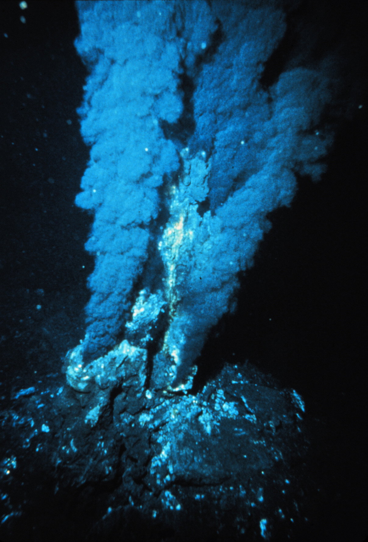
Fig. 4. Hydrothermal vents, called “black smokers” due to sulfide minerals being suspended in the hot saline hydrothermal fluids, on the mid-ocean ridge of the Atlantic Ocean (P. Rona / OAR/National Undersea Research Program (NURP); NOAA, Public domain, via Wikimedia Commons)
This hydrothermal precipitite model accounts for the salt beds forming on the Red Sea floor today, beneath hydrothermal brine layers in pools within basins.50 The bedded salt deposits, up to 5,000 meters [~16,400 feet] thick, on the flanks of the Red Sea, and underneath where salt beds are precipitating today, confirm that the presently active hydrothermal precipitation of these bedded salt deposits is related to the formation of ancient precipitite deposits.51 Further evidence that supports the hydrothermal precipitite model for the formation of ancient salt deposits includes:
- The proportion of the different salt minerals found in ancient salt beds is completely different from what theoretical and experimental geochemical methods would predict based upon the uniformitarian evaporite model.52 Salt beds contain great thicknesses of primarily one salt mineral to the exclusion of all others. Furthermore, some of the more soluble salts, such as magnesium sulfate, are absent in large salt beds, whereas they generally form in the claimed modern analogous evaporative lagoons.53
- Some of the associations of salt minerals indicate high temperatures of deposition, such as 83°C [181°F] for a magnesium sulfate with potassium chloride.54 The huge German salt beds contain large amounts of these salt minerals that require high depositional temperatures near the boiling point of water. But these temperatures are not found in modern depositional settings for evaporite deposits.
- Bedded salt deposits are frequently associated with volcanics.55 Indeed, volcanics are associated with the Messinian salt deposits of the Mediterranean basin.56
- Bedded salt deposits are frequently associated with rifting, mountain-building, and faulting that coincide with magmatic, volcanic, and hydrothermal activity.57
Clearly, this hydrothermal precipitite model implies that these Mediterranean Messinian salt beds may have accumulated in only a few years, which would thus be consistent with all this occurring soon after the biblical global Flood cataclysm. Continued rapid outpourings of huge volumes of salt-saturated hydrothermal fluids (associated with volcanic activity as tectonic movements of the African and Eurasian plates in the Mediterranean region finally slowed to their current snail’s pace) resulted in the deposition of these thick Messinian salt beds interlayered with rapidly deposited marine muddy sediments during decades of the after-effects of the biblical global-Flood cataclysm about 4,500 years ago.
The Zanclean (Mediterranean) Mega Flood
To facilitate hydrothermal precipitite deposition of the Messinian salt beds, the available evidence does not suggest the water level in the Mediterranean Sea basin had to fall drastically to essentially dry out the basin. Instead, due to the (likely temporary) tectonic closure of the Strait of Gibraltar at the entrance to the Mediterranean Sea, cutting off replenishment of its waters from the Atlantic Ocean, there would likely have been only a modest fall in the Mediterranean Sea’s water level. Furthermore, the observed huge incisions on the floor of the Mediterranean basin and on the opposite side of the Strait of Gibraltar provide impeccable evidence of catastrophic erosive downcutting by a mega flood, as confirmed by appropriate incision modeling. Coupled with that is evidence of the rapid deposition of marine sediment layers abruptly overlying the Messinian salt beds, indicating fast-moving waters.
Thus, the concept of the Zanclean mega flood seems entirely plausible and reasonable as a consequence of the ongoing after-effects during the decades following the biblical global-Flood cataclysm about 4,500 years ago. With continued tectonic adjustments, the Strait of Gibraltar reopened, and the waters of the Atlantic Ocean cascaded into the Mediterranean basin, scouring the seafloor and abruptly depositing marine sediments over the Messinian salt beds, raising the Mediterranean Sea level to approximately its current height. However, there likely would have been no impact on human activities, because this would have all occurred in the decades after the Flood, prior to the dispersion from Babel, when Noah and his descendants were still all living together far away from the Mediterranean Sea basin, either still in the mountains of Ararat or down on the plain of Shinar.
Answers in Depth
2026 Volume 21

Answers in Depth explores the biblical worldview in addressing modern scientific research, history, current events, popular media, theology, and much more.
Browse VolumeFootnotes
- Hsü, K. J., William B. F. Ryan, and M. B. Cita, “Late Miocene Desiccation of the Mediterranean,” Nature 242 (March 23, 1973): 240–244, https://doi.org/10.1038/242240a0.
- Govers, Rob, “Choking the Mediterranean to Dehydration: The Messinian Salinity Crisis,” Geology 37, no. 2 (February 2009): 167–170, https://doi.org/10.1130/G25141A.1.
- Garcia-Castellanos, D., F. Estrada, I. Jiménez-Munt, C. Gorini, M. Fernàndez, and J. Vergés et al., “Catastrophic Flood of the Mediterranean After the Messinian Salinity Crisis,” Nature 462 (December 10, 2009): 778–781, https://doi.org/10.1038/nature08555.
- Garcia-Castellanos et al., “Catastrophic Flood of the Mediterranean,” 778.
- Ryan, W. B. F., et al., Initial Reports of the Deep Sea Drilling Project, vol. 13 (Washington: US Government Printing Office, 1973); Hsü et al., “Late Miocene Desiccation of the Mediterranean,” Figs. 2 and 9.
- Rouchy, J. M., and A. Caruso, “The Messinian Salinity Crisis in the Mediterranean Basin: A Reassessment of the Data and an Integrated Scenario,” Sedimentary Geology 188–189 (2006): 35–67, https://doi.org/10.1016/j.sedgeo.2006.02.005.
- Ryan et al., Initial Reports of the Deep Sea Drilling Project; Hsü et al., “Late Miocene Desiccation of the Mediterranean.”
- Ryan, William B. F., D. J. Stanley, J. B. Hersey, D. A. Fahlquist, and I. D. Allan, in The Sea, ed. A. C. Maxwell (New York: John Wiley, 1971).
- Hsü et al., “Late Miocene Desiccation of the Mediterranean,” 241.
- Hsü et al., “Late Miocene Desiccation of the Mediterranean,” 240–241.
- Hsü et al., “Late Miocene Desiccation of the Mediterranean,” 241.
- Hardie, L. A., “The Gypsum—Anhydrite Equilibrium at One Atmosphere Pressure,” American Mineralogist 52, no. 1–2 (February 1967): 171–200.
- Warren, J., “Dolomite: Occurrence, Evolution and Economically Important Associations,” Earth-Science Reviews 52 (2000): 1–81; M. Ning, X. Lang, K. Huang, C. Li, T. Huang, and H. Yuan et al., “Towards Understanding the Origin of Massive Dolostones,” Earth and Planetary Science Letters 545 (September 1, 2020): 116403, https://doi.org/10.1016/j.epsl.2020.116403.
- Haq, B., C. Gorini, J. Baur, J. Moneron, and J.-L. Rubino, “Deep Mediterranean’s Messinian Evaporite Giant: How Much Salt?,” Global and Planetary Change 184 (January 2020): 103052, https://doi.org/10.1016/j.gloplacha.2019.103052; G. Aloisi, J. Moneron, L. Guibourdenche, A. Camerlenghi, I. Gavrieli, and G. Bardoux et al., “Chlorine Isotopes Constrain a Major Drawdown of the Mediterranean Sea During the Messinian Salinity Crisis,” Nature Communications 15 (2024): 9671, https://doi.org/10.1038/s41467-024-53781-6.
- Haq et al., “Deep Mediterranean’s Messinian Evaporite Giant: How Much Salt?”
- Hsü et al., “Late Miocene Desiccation of the Mediterranean,” 243.
- Ryan et al., Initial Reports of the Deep Sea Drilling Project.
- Ryan et al., Initial Reports of the Deep Sea Drilling Project; Hsü et al., “Late Miocene Desiccation of the Mediterranean.”
- Garcia-Castellanos, D., and A. Villaseñor, “Messinian Salinity Crisis Regulated by Competing Tectonics and Erosion at the Gibraltar Arc,” Nature 480 (December 15, 2011): 359–363.
- Aloisi et al., “Chlorine Isotopes Constrain a Major Drawdown”; G. Clauzon, J.-P. Suc, F. Gautier, A. Berger, and M.-F. Loutre, “Alternate Interpretation of the Messinian Salinity Crisis: Controversy Resolved?,” Geology 24, no. 4 (April 1996): 363–366.
- Garcia-Castellanos et al., “Catastrophic Flood of the Mediterranean.”
- Clauzon, G., “The Messinian Var Canyon (Provence, Southern France): Paleogeographic Implications,” Marine Geology 27 (1978): 231–246; P. M. Barber, “Messinian Subaerial Erosion of the Proto-Nile Delta,” Marine Geology 44 (1981): 253–272.
- Gvirtzman, Z., H. Heida, D. Garcia-Castellanos, O. Bar, E. Zucker, and Y. Enzel, “Limited Mediterranean Sea-Level Drop During the Messinian Salinity Crisis Inferred from the Buried Nile Canyon,” Communications Earth & Environment 3 (2022): 216, https://doi.org/10.1038/s43247-022-00540-4.
- Gvirtzman et al., “Limited Mediterranean Sea-Level Drop.”
- Garcia-Castellanos, D., H. Heida, D. V. Palcu, F. Bulian, and F. Sierro, “Kilometric Sea Level Changes During the Messinian Salinity Crisis Caused by River Erosion and Climate,” Science Advances 11, no. 28 (July 11, 2025): eads9752, https://doi.org/10.1126/sciadv.ads9752.
- Blanc, P.-L., “The Opening of the Plio-Quaternary Gibraltar Strait: Assessing the Size of a Cataclysm,” Geodinamica Acta 15 (2002): 303–317; P. Th. Meijer and W. Krijgsman, “A Quantitative Analysis of the Desiccation and Refilling of the Mediterranean During the Messinian Salinity Crisis,” Earth and Planetary Science Letters 240 (December 1, 2005): 510–520.
- Campillo, A., A. Maldonado, and A. Mauffret, “Stratigraphic and Tectonic Evolution of the Western Alboran Sea: Late Miocene to Recent,” Geo-Marine Letters 12 (1992): 165–172; Blanc, “The Opening of the Plio-Quaternary Gibraltar Strait”; Garcia-Castellanos et al. “Catastrophic Flood of the Mediterranean.”
- Garcia-Castellanos et al., “Catastrophic Flood of the Mediterranean.”
- Garcia-Castellanos et al., “Catastrophic Flood of the Mediterranean.”
- Garcia-Castellanos, D., A. Micallef, F. Estrada, A. Camerlenghi, G. Ercilla, and R. Periáñez et al., “The Zanclean Megaflood of the Mediterranean—Searching for Independent Evidence,” Earth-Science Reviews 201 (2020): 103061, https://doi.org/10.1016/j.earscirev.2019.103061.
- Garcia-Castellanos et al., “Catastrophic Flood of the Mediterranean.”
- Garcia-Castellanos et al., “Catastrophic Flood of the Mediterranean.”
- Garcia-Castellanos et al., “Catastrophic Flood of the Mediterranean.”
- Garcia-Castellanos et al., “Catastrophic Flood of the Mediterranean.”
- Garcia-Castellanos et al., “The Zanclean Megaflood of the Mediterranean.”
- Garcia-Castellanos et al., “The Zanclean Megaflood of the Mediterranean.”
- I have previously discussed a biblically compatible explanation of layered salt beds, including the Messinian sequence. This section is largely reproduced and adapted from Andrew A. Snelling, Earth’s Catastrophic Past: Geology Creation & the Flood, vol. 2 (Dallas, TX: Institute for Creation Research, 2009), 939–944.
- Clarke, F. W., The Data of Geochemistry, 5th ed., US Geological Survey Bulletin 770 (Washington: US Government Printing Office, 1924).
- Borchert, H., and R. O. Muir, Salt Deposits: The Origin, Metamorphism, and Deformation of Evaporites (London: Van Nostrand, 1964).
- Rouchy and Caruso, “The Messinian Salinity Crisis in the Mediterranean Basin.”
- Blatt, H., G. Middleton, and R. Murray, Origin of Sedimentary Rocks (Engelwood Cliffs, NJ: Prentice-Hall, 1972), 501–504.
- Heerema, S. J., “A Magmatic Model for the Origin of Large Salt Formations,” Journal of Creation 23, no. 3 (2009): 116–118; S. J. Heerema, and G.-J. H. A. van Heugten, “The Igneous Origin of Salt Deposits and Structures,” Journal of Creation 36, no. 2 (2022): 58–60.
- Heerema, S. J., and G.-J. H. A. van Heugten, “Salt Magma and Sediments Interfingered,” Journal of Creation 32, no. 2 (2018): 118–123.
- Krauskopf, K. B., Introduction to Geochemistry (New York: McGraw-Hill, 1967); H. Hodes, P. Griffiths, K. A. Smith, W. S. Hurst, W. J. Bowers, and K. Sako, “Salt Solubility and Deposition in High Temperature and Pressure Aqueous Solutions,” American Institute of Chemical Engineers Journal 50, no. 9 (2004): 2038–2049, https://doi.org/10.1002/aic.10238.
- Rona, P. A., G. Klinkhammer, T. A. Nelson, H. Trefry, and H. Elderfield, “Black Smokers, Massive Sulfides and Vent Biota at the Mid-Atlantic Ridge,” Nature 321 (1986): 33–37; K. L. Von Damm, “Seafloor Hydrothermal Activity: Black Smoker Chemistry in Chimneys,” Annual Review of Earth and Planetary Sciences 18 (1990): 173–204.
- Lowell, R. P., and L. N. Germanovich, “Evolution of a Brine-Saturated Layer at the Base of a Ridge-Crest Hydrothermal System,” Journal of Geophysical Research 102, no. B5 (1997): 10,245–10,255; K. L. Von Damm, M. D. Lilley, W. C. Shanks III, M. Bockington, A. M. Bray, K. M. O’Grady, E. Olson, A. Graham, and B. Proskurowski, “Extraordinary Phase Separation and Segregation in Vent Fluids from the Southern East Pacific Rise,” Earth and Planetary Science Letters 196 (2002): 1–4.
- Sozansky, D. I., “Origin of Salt Deposits in Deep-Water Basins of the Atlantic Ocean,” American Association of Petroleum Geologists Bulletin 57, no. 3 (1973): 589–590; D. I. Nutting, “Origin of Bedded Salt Deposits: A Critique of Evaporative Models and a Defense of a Hydrothermal Model,” (master’s thesis, Institute for Creation Research Graduate School, 1984); M. Hovland, H. G. Rueslåtten, H. K. Johnsen, B. Kvanne, and T. Kuznetsova, “Salt Formation Associated with Sub-Surface Boiling and Supercritical Water,” Marine and Petroleum Geology 23 (2006): 855–869.
- Bischoff, J. L., “Red Sea Geothermal Brine Deposits: Their Mineralogy, Chemistry and Genesis,” in Hot Brines and Recent Heavy Metal Deposits in the Red Sea: A Geochemical and Geophysical Account, eds. E. T. Dedgens and D. A. Ross (New York: Springer-Verlag, 1969), 368–401; Hovland et al., “Salt Formation Associated with Sub-Surface Boiling and Supercritical Water.”
- Raup, O. B., “Brine Mixing: An Additional Mechanism for Formation of Basin Evaporites,” American Association of Petroleum Geologists Bulletin 54, no. 12 (1970): 2246–2259; F. L. Wilcox and S. T. Davidson, “Experiments on Precipitation Brought About by Mixing Brines,” Creation Research Society Quarterly 13, no. 2 (1976): 87–89.
- Hovland et al., “Salt Formation Associated with Sub-Surface Boiling and Supercritical Water.”
- Savoyat, G., A. Shiferaw, and T. Balcha, “Petroleum Exploration in the Ethiopian Red Sea,” Journal of Petroleum Geology 12 (1989): 187–204; F. Orszag-Sperber, P. Harwood, A. Kendall, and B. H. Purser, “A Review of the Evaporites of the Red Sea-Gulf of Suez Rift,” in B. H. Purser and D. W. J. Bosence, eds., Sedimentation and Tectonics of Rift Basins: Red Sea-Gulf of Aden (London: Chapman and Hall, 1998), 409–426.
- Krauskopf, Introduction to Geochemistry, 319–353.
- Porfir’ev, V. B., “Geology and Genesis of Salt Formations,” American Association of Petroleum Geologists Bulletin 58 (1974): 2543–2544.
- Stewart, F. H., “Marine Evaporites,” in M. Fleischer, ed., Data of Geochemistry, 6th ed., US Geological Survey Professional Paper 440-Y (Washington: US Government Printing Office, 1963); Krauskopf, Introduction to Geochemistry, 346.
- Sozansky, “Origin of Salt Deposits in Deep-Water Basins”; Porfir’ev, “Geology and Genesis of Salt Formations.”
- Nesteroff, W. B., F. C. Wezel, and G. Pautot, “Summary of Lithostratigraphic Findings and Problems,” in W. B. F. Ryan, K. Hsü et al., eds., Initial Reports of the Deep-Sea Drilling Project, vol. 13 (Washington: US Government Printing Office, 1973), 1021–1040; L. Jolivet, R. Augier, C. Robin, J.-P. Suc, and J. M. Rouchy, “Lithospheric-Scale Geodynamic Context of a Messinian Salinity Crisis,” Sedimentary Geology 188–189 (2006): 9–33.
- Pautot, G., J. Auzende, and X. Pichon, “Continuous Deep Sea Salt Layer Along North Atlantic Margins Related to Early Phase of Rifting,” Nature 227 (1970): 351–354.




Support the creation/gospel message by donating or getting involved!

Answers in Genesis is an apologetics ministry, dedicated to helping Christians defend their faith and proclaim the good news of Jesus Christ.
- Customer Service 800.778.3390
- Available Monday–Friday | 9 AM–5 PM ET
- © 2026 Answers in Genesis