Sifting Through Layers of Meaning
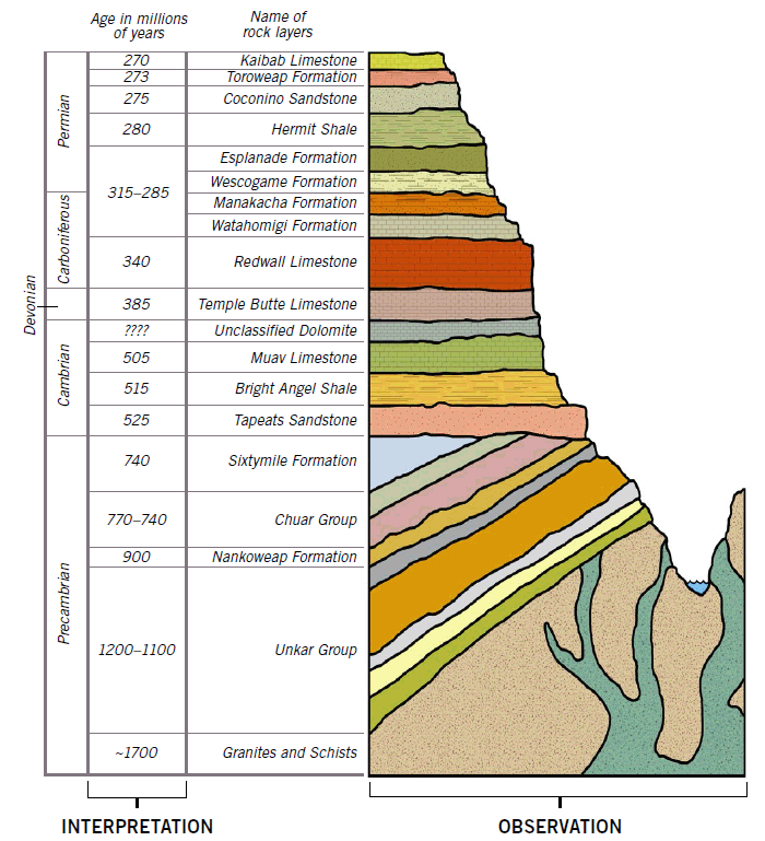
According to science textbooks, a series of rock layers covers the earth, representing many eras over “millions of years.” Do these charts have any connection with reality?
Most Christians who grew up in church heard Sunday school lessons about Adam in the Garden of Eden and Noah on the Ark, surrounded by bunny rabbits and dairy cows munching happily on grass. As they grew up, however, images of the “earth shaker” Seismosaurus or sea monsters like Mosasaurus shattered these simplistic scenes of life on earth before the Flood.
Meanwhile, science class and natural history museums presented a different picture. Colorful scientific charts depicted a thick stack of rock layers full of dinosaurs and other creatures that supposedly lived millions of years ago—the geologic column. Given this conflict, churchgoers had a choice to make. At one extreme, some denied that dinosaurs existed altogether, and they called the geologic column a lie. On another extreme, some abandoned the Bible, choosing what appeared to be science over God's Word.
But there’s a third option. We can—and should—embrace both the Bible and the science, including fossils and the sequence of rock layers portrayed in the geologic column. Scientists have made many exciting discoveries about rocks that are observable and repeatable. We can use these to help us reconstruct the past without accepting the labels for “millions of years,” which are based on faulty assumptions.
When sharing their faith, Christians need to be very careful to distinguish between observation and interpretation. If they reject observation along with interpretation, they may be perceived as anti-science and lose all credibility as they witness for Christ.
Understanding a few simple things about geology makes it possible for any Christian to converse about how God’s Word explains our world, including dinosaurs and rock layers. Modern discoveries are not just consistent with the Bible, they provide astonishing confirmations of the Bible’s version of earth history when we look more closely.
Are Stratigraphic Charts Made Up?
If you spend much time driving along hilly countryside highways, you’ll eventually pass cuts in the hills that straighten the highways or reduce their steepness. As you drive by road cuts in close succession, you’ll likely notice that the rock layers in each cut look strikingly similar. These patterns are real and visible.
Long before engineers ever cut through these hills, natural erosion had already exposed some of the region’s layers, in features called outcrops. In past centuries, geologists used these outcrops to produce charts that summarize the rock patterns in each region.
Creationists can confidently use stratigraphic charts to understand the order that layers were formed.
These diagrams are called stratigraphic charts, which geologists draw up to represent and summarize the rock layers in local areas. But can we trust their accuracy?
The layers in these diagrams are not contrived based on any uniformitarian or evolutionary bias. They are real patterns that we can measure and test. In effect, these represent rock layers that are visible to the eye. By comparing the contents of one layer to another, we can trace any layer from place to place and determine where in the overall sequence of layers (the geologic column) it belongs. Without exception, we observe a one-to-one correspondence between what is depicted on the charts and what is found in the layers at outcrops and road cuts.
Today geologists access additional data, such as well core samples from oil exploration drilled deep in the earth and chemical tests from the laboratory, which they can use to match and verify where each layer belongs in the sequence. Each layer has a unique “fingerprint,” as it were, that sets it apart from all others. (More on that later.)
Are the Dates Wrong?
While the order of layers in stratigraphic charts is based on factual observations, one important detail is not. Rock layers are never observed to have labels on them stating how old they are. Yet stratigraphic charts always label the rock layers with names of geologic “periods,” tens or hundreds of millions of years ago. This information is opinion, based on interpretations by evolutionary geologists, not observed facts.
That’s where confusion arises between observation and interpretation. But we don’t want to throw out the baby with the bathwater, as the saying goes. There is no need to deny an observable sequence of rock layers (the geologic column), as many Christians have done, just because someone mistakenly labels them as “millions of years old.”
God made us in His image so we could learn from His creation (Psalm 19:1–4; Romans 1:18–20). Our senses are reliable, and God gave us our ability to discern patterns in nature. These patterns help us figure out the world around us, but always through the lens of Scripture.
With the help of God’s Word, we can fill in the gaps of our understanding about early history. The patterns in the rocks, if interpreted correctly, provide us with a powerful tool to explain why billions of fossilized animals and plants are buried and incredibly well preserved in sedimentary rock layers all around the earth. The answer is the worldwide Flood of Noah’s day!
Relative Dating
Based on biblical time references, we know for certain that “absolute dates” of millions of years can’t be right. But is it still possible to establish the sequence of geologic events? Yes! The process is called “relative dating.”
Here’s how it works. Suppose you come across a stack of pancakes accidentally left on the counter in a kitchen that was shut down a year ago. You can still make some reasonable conclusions about the history of those pancakes. For example, the pancake at the bottom of the pile probably came off the griddle first, while the pancake at the top came off last. But it is difficult, if not impossible, to know how many seconds (or minutes or hours or days) passed between the cooking of one pancake and the next.
In geology, the view that the lower layers are the oldest is called “superposition.” It is based on observation, experiments, and sound logic.
The Principle of Superposition
About the middle of the seventeenth century Nicolaus Steno, a Danish court physician living in Italy, began investigating the fossil-bearing sedimentary layers around Rome. As a result, he made the first known attempt to place the rock layers in some kind of positional order. In 1669 he postulated that in any sequence of flat sedimentary layers, the oldest layers are at the bottom because they were deposited first, and the youngest are at the top because they were deposited later.
Steno also observed a surprising pattern in the layers: it appears that the layers were always deposited initially in a nearly horizontal position, even though today they may be found tilted at various other angles. He also observed another pattern: each layer appears to have formed as a continuous sheet that stretched over large areas until something stopped its spread.
What processes could produce such massive pancake-like layers of rock that spread over continents? Most secular textbooks will not tell you that Steno was a Christian who believed Noah’s Flood was responsible for depositing the layers. He regarded the principle of superposition as describing the order in which the layers were deposited during the Flood. The time that passed between the deposition of the layers would be relatively short, within the year of the Flood. He believed rock layers showed the passage of time, but only minutes, hours, days, or weeks.
Similarly, Steno believed the Flood explained the horizontal continuity of the layers. After all, the Scriptures describe the Flood as being a global catastrophe. So we would expect the ocean waters to rise and sweep across the continents, and then deposit fossil-rich layers that can be traced laterally over a significant regional area, and even continental extent.
Four Tools to Correlate Layers
How can scientists connect the sedimentary layers in one area to the layers in other areas, even on the other side of the continent, if we don’t have the benefit of long, continuous road cuts?
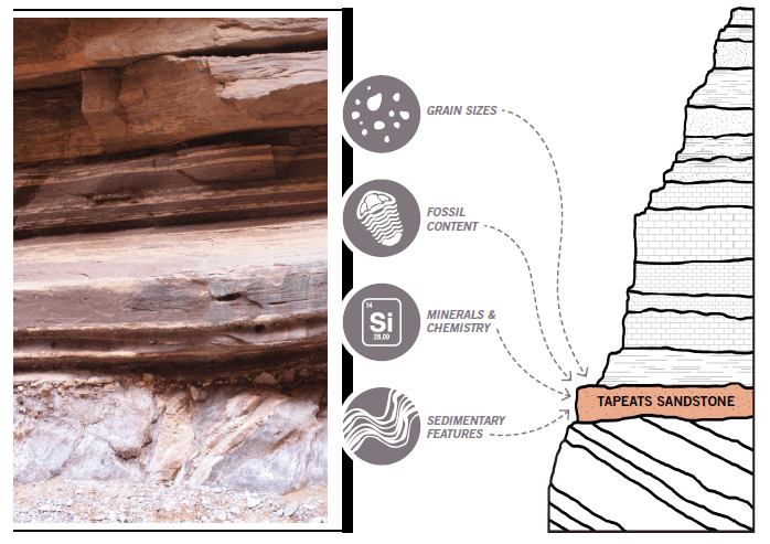
Let’s consider a practical example. You’re driving around the American Southwest and come across an outcrop of rock layers. You look closer and notice the tan-colored layer consists of large sandy particles, fossils of ocean creatures called trilobites, and many stacked “wavy” patterns. Which layer does this outcrop belong to?
Geologists have four major tools at their disposal. This is not guesswork, but hard science performed by evolutionists and creationists alike—as they take measurements and compare the content of each layer to find matches with other locations.
Grain Sizes
One of the most obvious ways to identify a rock layer is the size of the particles in the rocks. Sedimentary rocks are made up of different particle sizes. The terms sand, silt, and mud refer to the particle sizes, from largest to smallest. The rock layers containing each size are called sandstone, siltstone, and mudstone respectively. So it appears you have discovered a layer of sandstone.
Fossil Content
Similarly we can identify sedimentary rocks by the fossils they contain. If the sandstone contains marine fossils called trilobites, it likely belongs to the Tapeats Sandstone, the layer found in the Grand Canyon that also has the same types of trilobites. If instead it contains fossilized footprints of tetrapods (amphibians or reptiles), it likely belongs to the Coconino Sandstone layer, also found in the Grand Canyon. (The Coconino has tetrapod prints but not trilobites.)
This is not an exercise in circular reasoning. Geologists have catalogued literally millions of sites worldwide, and they consistently find different kinds of fossils in different layers, and the same fossils in the same layers. For instance, trilobites are never found in uppermost layers, and tetrapods are never found in the lowermost layers. Biblical geologists believe this pattern indicates that animals and plants from different parts of the world were buried in an order in separate layers by the Flood waters.
Minerals and Chemistry
Because of the different minerals they contain, sedimentary rocks have different chemical compositions. Sandstone, for example, often consists mostly of sand-sized particles of the mineral quartz (silicon dioxide). When rock samples are crushed and chemically analyzed, all sandstone layers have high silicon content. However, the Tapeats Sandstone also has the mineral feldspar in it, and so it has more potassium than Coconino Sandstone. Also, rocks have cements that bind the grains together, and these cements have different chemical contents that help us distinguish one type of sandstone from another.
Knowing this chemistry has an added benefit. We can sometimes locate the rocks where the sands came from! Geologists can use the cements, minerals, and chemical makeup to find distant rocks whose chemistry matches the sand. For instance, the chemical makeup of zircon grains in the Coconino Sandstone shows that they were eroded from the Appalachian Mountains and transported over 1800 miles (2900 km) across the continent.1
Sedimentary Features
Many sediment layers also contain visible layering that resembles water ripples or “waves” that reflect the way they were deposited. For example, if water transports sand grains and builds up into waves, the sandstone will contain a feature known as cross-beds. The shape, size, and direction of these “fossil waves” show us the direction and speed of the water when it flowed, and sometimes even the depth. We find these wave features in both the Coconino Sandstone and Tapeats Sandstone of the Grand Canyon area. So can we tell the difference? Yes, the “fossil waves” in each are different sizes and shapes due to different water speeds!
The Tapeats Sandstone in the Grand Canyon was deposited much more violently than the Coconino Sandstone. At its base are boulders and mineral grains ripped from bedrock just below the deposit. Rapidly flowing water violently eroded everything in its path and ripped up debris, which was then deposited at the base of the resulting sandstone. The stacked, repeated small “fossil waves” in the Tapeats Sandstone were very likely produced by hurricane-velocity, storm-driven water currents.
Most biblical geologists believe, in fact, that the Tapeats Sandstone is the first deposit in this area after the Flood began to rip apart the ocean floor.
A Local Geologic Column
Now let’s start applying what we have learned to a local geologic column in the Grand Canyon.
As we travel around the area, we observe that the sequence of layers exists in the same order everywhere we go. The Tapeats Sandstone is always at the bottom of the stack, so we can conclude it was deposited first. The Coconino Sandstone is always higher up in the stack, and other layers between them are always the same.
Any layer and its fossils can be dated relative to the other layers.
Furthermore, the Tapeats and Coconino Sandstones are always distinguishable not just because of their relative positions but because of their different grain sizes, fossil contents, minerals and chemistry, and sedimentary features.
This local geologic column includes many other sedimentary layers in the region. If you drive to the north up the so-called Grand Staircase in northern Arizona and southern Utah, you find another 10,000 feet (3048 m) of stacked “pancake” layers that start right on top of the 4,500 feet (1370 m) of sedimentary layers exposed in the Grand Canyon.
So this comprehensive local geologic column is an observable reality, and not contrived. It clearly represents the order that sediments and fossils were buried during the global Flood cataclysm. This means that any one layer and its fossils within this sequence can be dated relative to the other layers.
Continental and Global Correlations
So is there a way to relate the layers in one area to those in another?
If we drive to the east of the Grand Canyon into New Mexico, we observe a sandstone with exactly the same features as the Coconino Sandstone. It also appears at the same approximate level in the local strata column.
As we move farther away, we find other local strata columns that have the same sandstone, the same grain sizes, the same fossils, the same mineral and chemical makeup, and the same sedimentary features. We can demonstrate that every one of these layers is the Coconino Sandstone by drilling wells across that vast region and matching the cores. Each site exhibits very similar patterns.
The farther we travel away from the Grand Canyon, the more likely the rocks will begin to change slightly. But the layers still have enough similarities to help us determine the relative order at each new site.
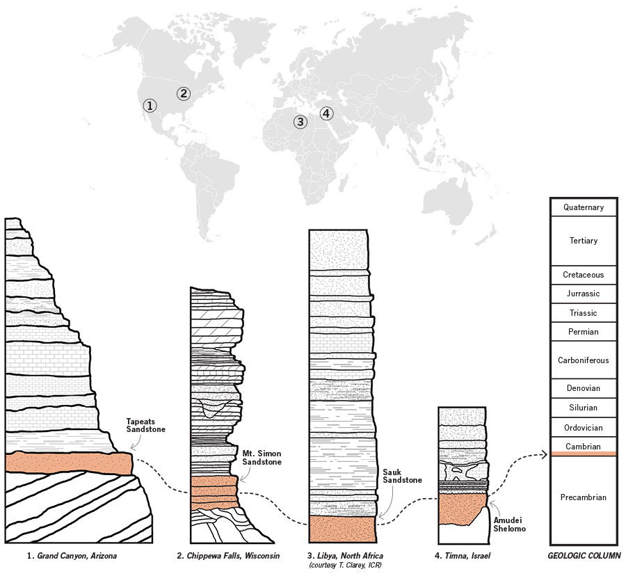
If we examine every strata column throughout North America, we make an astounding observation. Near the base of most local strata columns is a sandstone containing trilobite fossils sitting on top of eroded bedrock—for example, near Chippewa Falls in northwestern Wisconsin. These sandstones are at the same relative level as the Tapeats Sandstone in the Grand Canyon. They also have the same features—grain sizes, fossils, mineral and chemical makeup, and sedimentary features.
Yet there is more! If we go across the ocean to the Timna area of southernmost Israel and at Petra in Jordan, we observe a sandstone with the same grain sizes, fossils, mineral and chemical makeup, and sedimentary features as the Tapeats Sandstone. And it sits on top of eroded bedrock exactly like the one in the Grand Canyon. This sandstone continues across much of northern Africa. (This is not just a creationist assertion but has also been noted by others, including evolutionary geologists.) Such an intercontinental extent is powerful confirmation of the global reach of the Genesis Flood.
Only a Global Flood Could Explain Layers Across Continents
Geologists have developed stratigraphic charts for local layers around the world. Using chemistry and other major tools, they can match the layers to each other. For instance, the Grand Canyon has a unique sandstone known as the Tapeats Sandstone. Other regions have the same basic sandstone, which always appears at the bottom of the stack of sedimentary layers.
The only mechanism that could spread such thick layers of sand over many continents is the Genesis Flood. The sequence gives us “relative dates” for deposits—which ones occurred “early,” “middle,” or “late” in the sequence. These are based on factual observations, not interpretation. Interpretations come into place when we try to label each layer with an “absolute date,” whether thousands or millions of years.
Conclusion
Relative dating is a valuable tool that helps us make sense of the observed patterns in the rock layers around the earth. In fact, it vividly demonstrates the global nature of the Flood. This dating technique is not the same as radiometric dating, which gives incorrect “absolute” dates. Instead, it is a scientific process that produces “relative” dates—the sequence of events that produced each layer, not the total time that passed.
Creationists can confidently use stratigraphic charts and the geologic column to understand the order that layers were formed, especially during God’s Flood judgment. If we ignore the interpreted idea of millions of years, we can see these geologic “periods” as “snapshots” of deposits during different stages of the Flood. Using the timeframe given in Genesis, we can conclude that most fossil-bearing sedimentary layers were deposited rapidly in just a year. To deny the reality of local geologic columns and relative dating strips away a powerful, faith-affirming evidence for the global Flood.
God graciously gave us observational tools to help us study our world and show people the “clear” evidence for His handiwork (Romans 1:18–20). He expects us to take advantage of these tools, as we share His work with the nations!
Related Videos
Layers of Meaning
Answers Magazine
October–December 2015
Learn what the Bible really teaches about caring for the environment and read the shocking results of a survey showing what the twentysomethings in your church believe.
Browse IssueFootnotes
- The chemical makeup of a rock layer includes not only major elements like silicon but trace elements like strontium and lead, and even daughter isotopes generated by the breakdown of radioactive parents atoms such as rubidium and uranium. In this case it was the daughter lead isotope contents of the zircon grains in the Coconino Sandstone which matched those in the source rocks in the Appalachians. The same erosion source and transport distance has now been demonstrated for many of the other sedimentary layers in the Grand Canyon, from the Tapeats Sandstone upwards. George E. Gehrels, Ron Blakey, Karl E. Karlstrom, J. Michael Timmons, Bill Dickinson, and Mark Pecha, “Detrital Zircon U-Pb Geochronology of Paleozoic Strata in the Grand Canyon, Arizona,” Lithosphere 3.3 (2011): 183–200.
Recommended Resources

Answers in Genesis is an apologetics ministry, dedicated to helping Christians defend their faith and proclaim the good news of Jesus Christ.
- Customer Service 800.778.3390
- Available Monday–Friday | 9 AM–5 PM ET
- © 2026 Answers in Genesis


