Chapter 23
Aren’t Millions of Years Required for Geological Processes?
Millions of years are not required to explain the earth’s rocks, as Hutton, Lyell, Darwin, and so many others have assumed.
Geology became established as a science in the middle to late 1700s. While some early geologists viewed the fossil-bearing rock layers as products of the Genesis Flood, one of the common ways in which most early geologists interpreted the earth was to look at present rates and processes and assume these rates and processes had acted over millions of years to produce the rocks they saw. For example, they might observe a river carrying sand to the ocean. They could measure how fast the sand was accumulating in the ocean and then apply these rates to a sandstone, roughly calculating how long it took sandstone to form.
Similar ideas could be applied to rates of erosion to determine how long it might take a canyon to form or a mountain range to be leveled. This type of thinking became known as uniformitarianism (the present is the key to the past) and was promoted by early geologists like James Hutton and Charles Lyell.
These early geologists were very influential in shaping the thinking of later biologists. For example, Charles Darwin, a good friend of Lyell, applied slow and gradual uniformitarian processes to biology and developed the theory of naturalistic evolution, which he published in the Origin of Species in 1859. Together, these early geologists and biologists used uniformitarian theory as an atheistic explanation of the earth’s rocks and biology, adding millions of years to earth history. The earlier biblical ideas of creation, catastrophism, and short ages were put aside in favor of slow and gradual processes and evolution over millions of years.
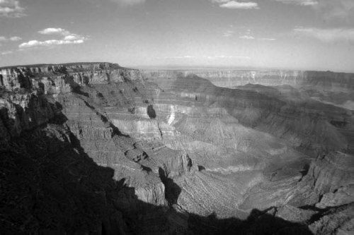
Figure 1. Layered sedimentary rocks from the Grand Canyon, Arizona. Photo by John Whitmore.
This chapter will document that geological processes that are usually assumed to be slow and gradual can happen quickly. It will document that millions of years are not required to explain the earth’s rocks, as Hutton, Lyell, Darwin, and so many others have assumed.
Rapid Lithification of Sedimentary Rock
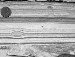
Figure 2. Finely laminated sedimentary layers from the Green River Formation, Wyoming. The U.S. penny is for scale (1.9 cm diameter). The dark oblongshaped objects between the laminations are fish coprolites (feces). As many as ten laminations per mm can occur in these rocks. Photo by John Whitmore.
Long periods of time are not required to harden rock. Sedimentary rock generally consists of sediment (mud, sand, or gravel) that has been turned into rock. Sedimentary rocks include sandstones, shales, and limestones. Sedimentary rock is usually formed under water and is easy to recognize because of its many layers. A familiar example would be the layered rocks of the Grand Canyon (figure 1).
Layers in sedimentary rocks can be seen at small scales too, like the finely laminated beds from the Green River Formation in Wyoming (figure 2). When sediment turns into rock, or becomes hard, we say the sediment has become lithified. Lithification occurs during sediment compaction (which drives out water) and cementation, or gluing together of the sedimentary grains. The process of lithification is not time dependent, but rather dependent upon whether the rock becomes compacted or not and whether a source of cement is present (usually a mineral like quartz or calcite). If these conditions are met, sediment can be turned rapidly into rock.

Figure 3. Remains of a clock encased in sedimentary rock. It was found on a beach along the coast of Washington state by Dolores Testerman.
Many examples of rock forming rapidly have been reported in the creationist literature: a clock (figure 3),1 a sparkplug,2 and keys3 have all been found in cemented sedimentary rock. Also a hat4 and a bag of flour5 have been found petrified. Examples of bolts, anchors, and bricks found in beach rock have also been reported.6 All of these examples show that sediment and other materials can be hardened within a relatively short time span. In many of these examples, rock probably formed as microbes (microscopic bacteria and other small organisms) precipitated calcite cement, which in turn bound sediments together and/or filled pore spaces. Examples of rapid lithification of this type include limestones that have been cemented together on the ocean floor.7
Rapid Formation of Thin, Delicate Rock Layers
Thin, delicate rock layers don’t necessarily represent quiet, docile sedimentary processes; thin layers of rock can be formed catastrophically. On May 18, 1980, Mount St. Helens violently erupted. It was one of the most well-studied and scientifically documented volcanic eruptions in earth history, both by conventional scientists8 and creationists.9
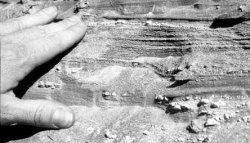
Figure 4. Finely laminated beds produced during a violent pyroclastic flow from Mount St. Helens on June 12, 1980. Photo by Steve Austin, copyright 1989, Institute for Creation Research; used by permission.
The volcano remained geologically active during the months and years following the 1980 eruption. Fresh lava is still oozing out of the volcano today. During the violent eruptions of the volcano, pyroclastic material (hot volcanic ash and rock) was thrown from the volcano with hurricane force velocity. One of the most fascinating discoveries following the eruption was that some of these pyroclastic deposits, those that contained fine volcanic ash particles, were thinly laminated.10 When geologists see thin layers like this (figure 4), they usually assume that slow, delicate processes formed the layers (like mud settling to a lake bottom). However, in this case, the layers were formed during a catastrophic volcanic eruption.

Figure 5. A well-preserved fish (Knightia) from the Green River Formation, Wyoming. In order for fish to be preserved like this, before major decay ensues, the fish must be buried within days of death. Scale in cm. Photo by John Whitmore.

Figure 6. A fish (Diplomystus) that decayed for several days before burial, Green River Formation, Wyoming. Note the sloughed scales. Burial a few days after death, by a thin layer of calcite mud, arrested the decay and prevented the fish from complete destruction. Scale in cm. Photo by John Whitmore.
Other types of thin, delicate rock layers can also form quickly too. Fossil fish are very abundant in the thin, laminated mudstones of the Green River Formation of Wyoming (figure 2). After death, fish rot very quickly. Scales and flesh can slough off within a matter of days, and fish can completely disappear within a week or two.11 In order for the Green River fish to be preserved as well as they are, it would have been necessary for a thin layer of calcite mud to cover the fish immediately after death (figure 5).
These thin layers of mud are what make up the thin, laminated layers of the Green River Formation. If a fish is not covered immediately, but several days after its death, scales will slough off and scatter around the fish carcass (figure 6). Because many of the layers in the Green River Formation contain well-preserved fish, we can conclude that many of layers were formed within a day or two. A study of fish coprolites (feces) also concluded that the thin layers must have formed quickly.12 The Green River Formation was probably made in a post-Flood lake setting where sediments were accumulating rapidly.13 These few examples of thin layers being made quickly does not mean that all thinly laminated rock layers have formed quickly; it shows that some thinly laminated layers can form quickly.
Rapid Erosion
Erosion can happen catastrophically, at scales that are difficult for us to imagine. When standing along the edge of a canyon and seeing a river in the bottom, one is inclined to imagine that the very river in the bottom of the gorge has cut the canyon over long periods of time. However, geologists are realizing that many canyons have been cut by processes other than rivers that currently occupy canyons.
Massive erosion during catastrophic flooding occurs by several processes. This includes abrasion,14 hydraulic action,15 and cavitation.16 The “Little Grand Canyon” of the Toutle River was cut by a mudflow on March 19, 1982, that originated from the crater of Mount St. Helens. The abrasive mudflow cut through rockslide and pumice deposits from the 1980 eruptions. Parts of the new canyon system are up to 140 feet deep.
Engineer’s Canyon was also cut by the mudflow and is 100 feet deep. There is a small stream in the bottom of Engineer’s Canyon (figure 7). One would be inclined to think that this stream was responsible for cutting the canyon over long periods of time if one did not know the canyon was cut catastrophically by a mudflow. In this case, the canyon is responsible for the stream; the stream is not responsible for the canyon.
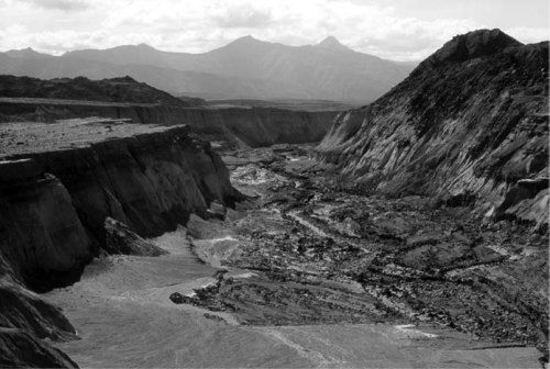
Figure 7. Engineer’s Canyon, Mount St. Helens, Washington. The canyon was cut by a mudflow originating from the crater of the volcano on March 19, 1982. The cliff on the left is about 100 feet high. Note the small stream in the bottom of the canyon. In this case, the stream did not form the canyon, the canyon came first and is responsible for the stream being there! Photo by Steve Austin, copyright 1989, Institute for Creation Research; used by permission.
Other large canyons and valleys are known to have been cut catastrophically as well. One of the most famous examples is the formation of the Channeled Scabland17 of eastern Washington state. The catastrophic explanation of the enigmatic topography is now well accepted, but when it was first proposed in the 1920s by J Harland Bretz,18 it was radical. The idea was not well accepted until nearly 50 years later, in 1969.
Bretz was trying to explain a whole series of deep, abandoned canyons (cut in hard, basaltic bedrock), dry waterfalls, deep plunge pools, hanging valleys, large stream ripples, gravel bars, and large exotic boulders. The Scabland formed as a glacier blocked the Clark Fork River in Idaho during the Ice Age. The glacially dammed river caused water to back up and form a huge lake (Lake Missoula) in western Montana, in places 2,000 feet deep!
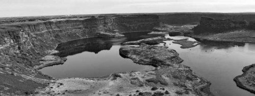
Figure 8. Dry Falls, near Coulee City, Washington. This is part of Grand Coulee, a canyon that is 50 miles long and as much as 900 feet deep, cut during the catastrophic Missoula Flood. The flood water poured over the lip of this 350-foot escarpment in the center of the photo, at five times the width of Niagara Falls. The lakes are filled plunge pools (300 feet deep) cut by water cascading over the cliff. Photo by John Whitmore.
Eventually, the ice dam burst, releasing water equivalent in volume to Lakes Erie and Ontario combined. The water rushed through Idaho and into eastern Washington, carving the Scabland topography. Hard basaltic bedrock was rapidly cut by abrasion, hydraulic action, and cavitation (figure 8). As the water drained into the Pacific Ocean, it created a delta more than 200 mi2 in size. It took Lake Missoula about two weeks to drain. It has been estimated that at peak volume, the flood represented about 15 times the combined flow of all the rivers in the world!19 Catastrophic floods of this magnitude were unthinkable at the height of uniformitarian geology in the early 1900s. Today, they are becoming more widely accepted as explanations of large parts of the earth’s topography.20
The origin of the Grand Canyon has been a topic of much speculation. Conventional geologists have not reached any consensus on its origin. Dr. Steve Austin, of the Institute for Creation Research, published in 1994 that the Grand Canyon was cut by a catastrophic flood that originated from post-Flood lakes ponded behind the Kaibab Upwarp.21 In 2000, a symposium was convened in Grand Canyon National Park to discuss the canyon’s origin. One paper22 was published that was similar to Austin’s idea, although the authors gave him no credit. Evidence in favor of the lake failure hypothesis for the catastrophic carving of the Grand Canyon is growing.
Recent work from the Anza Borrego Desert of California also supports this theory.23 Austin believes that several lakes ponded behind the Kaibab Upwarp, containing a volume of about 3,000 mi3 of water, about three times the volume of Lake Michigan,24 or about six times the volume of Lake Missoula. Austin proposed that the lakes drained because the limestones of the Kaibab Upwarp, which held back the ponded water and developed caves (through solution by carbonic acid), catastrophically piping the water out of the lakes, cutting the canyon.
Rapid Fossil Formation25
When an organism is turned into stone (i.e., fossilized), the process usually must happen rapidly, or the organism will be lost to decay. Taphonomy is a relatively new branch of geology that studies everything that happens from the death of an organism to its inclusion in the fossil record. Many experiments have been performed to see what happens to all types of animal carcasses in all types of settings including marine, freshwater, and terrestrial settings.
The goal of many of these experiments is to make actualistic taphonomic observations so the fossil record can be better understood. One common theme throughout many of these experiments is rapid disintegration of soft animal tissue. In the absence of scavengers, bacteria and other microbes can rapidly digest animal carcasses in nearly all types of environments. For example, I have documented that fish can completely disintegrate in time frames from days to weeks in both natural and laboratory settings under all types of variable conditions (temperature, depth, oxygen levels, salinity, and species).11 The taphonomic literature has shown this is generally true for many other types of organisms as well.26
Simply put, in order for an animal carcass to be turned into a fossil, it must be sequestered from decay very soon after death. The most common way for this to happen is via deep rapid burial so the organism can be protected from scavengers that may churn through the sediment in search of nutrients. Many fossil deposits around the world are considered to be Lagerstätten deposits (like the Green River Formation), or deposits that contain abundant fossils with exceptional preservation. It is widely recognized that most of these deposits were formed by catastrophic, rapid burial of animal carcasses.27
Common experience tells us that soft tissues disappear quickly if something doesn’t happen to prevent their decay. However, what about the hard parts of organisms, like clam or snail shells? Shouldn’t they be able to last almost indefinitely without being buried? Numerous experiments have been completed, watching what happens to shells on the ocean floor over time.26 Not surprisingly, these experiments have shown that thick, durable shells last longer than thin, fragile shells.
If the fossil record has accumulated by slow gradual processes, like those that are occurring in today’s oceans, then the fossil record should be biased toward thick, durable shells and against thin, fragile shells. This was exactly the hypothesis that a recent paper tested.28 The authors used the online Paleobiology Data Base, consisting of extensive fossil data from all over the world and throughout geologic time. Contrary to their expectations, they found thin, fragile material is just as likely to be found in the fossil record as thick, durable material. A reasonable interpretation of this finding (which the authors did not consider) is that much of the fossil record was produced catastrophically! This finding supports the hypothesis that much of the record was produced rapidly, during the Flood.
Rapid Coal Formation
Coal does not take long periods of time to form. Coal forms from peat, which is highly degraded wood and plant material. Peat looks much like coffee grounds or peat moss. During the Flood, large quantities of peat were likely produced and buried as a result of pre-Flood vegetation being ripped up and destroyed.
The extensive coal beds we find throughout the world may have also been the result of pre-Flood floating forests that were destroyed and buried.29 Coal has been produced experimentally in the laboratory from wood and peat.30 Most of these experiments have used reasonable geologic conditions of temperature (212–390°F, 100–200°C) and pressure (to simulate depth of burial). These experiments have succeeded in producing coal in just weeks of time. It appears time is probably not a significant factor in coal formation. The most important factors appear to be the quality of the organic material (peat), heat, and pressure (depth of burial).
Rapid Formation of Salt Deposits
Salt deposits can form in other places and in other ways besides large salt lakes that evaporate over long periods of time (like the Great Salt Lake in Utah or the Dead Sea in Israel). Geologists have traditionally interpreted thick salt deposits as evaporites. In other words, they picture a large basin of seawater (like the Mediterranean Sea) being enclosed and sealed off from the surrounding ocean. The confined salt water evaporates, forming a thick deposit of salt on the bottom of the basin.
Conventional scientists have recognized that this model is fraught with many paradoxes and unresolved problems.31 Recently, a new theory of salt formation has been proposed that overcomes some of these difficulties.32 This theory points out that salt is not very soluble33 at high temperatures and pressures. These situations are common near deep-sea hydrothermal vents. The authors cite examples from the Red Sea and Lake Asale (Ethiopia) where these situations exist and are associated with abundant salts. Several times throughout the paper, the authors cite that rapid deposition of the salt with accompanying rapid sedimentation rates are necessary conditions for the salt to be preserved. If the salt is not rapidly covered, it will dissolve back into the seawater when the conditions change.
Rapid Coral Reef Formation34
Under certain conditions, coral reefs can grow rapidly. Modern coral reefs are often small accumulations of corals, coralline algae, and other organisms that secrete calcium carbonate (calcite, the main ingredient of limestone) exoskeletons. However, some can be massive and thick, like the Great Barrier Reef (thickness of 180 feet [55 m])35 off the coast of Australia or Eniwetok Atoll36 (thickness of 4,590 feet [1,400 m])37 in the Marshall Islands of the Pacific. Some have argued that because of the slow growth rate of corals, large reefs need tens of thousands of years to grow.38 Corals, which build coral reefs, have been reported to grow as much as 4 to 17 inches (99–432 mm) per year.39
Large coral accumulations have been found on sunken World War II ships after only several decades.40 Acropora colonies have reached 23–31 inches (60–80 cm) in diameter in just 4.5 years in some experimental rehabilitation studies.41 At the highest known growth rates, the Eniwetok Atoll (the thickest known reef at 4,590 feet [1,400 m]) would have taken about 3,240 years to rise from the ocean floor. However, coral growth rate is not equal to reef growth rate; it is usually much less. Reef growth is a balance between constructive and destructive processes and has proved particularly difficult to measure. Reefs are constructed by coral growth and sediment, which settles and becomes cemented between reef organisms.
Modern reefs are destroyed by a number of processes, including active bioeroders (parrotfish, sea urchins), chemical dissolution, boring organisms (sponges, clams, and various worms), tsunamis, and storm waves. Reef growth occurs by the addition of mass, particularly from corals. Reef volume increases as living animals and their dead remains become cemented together with sediments to form the reef. Reef growth slows or even stops as the reef reaches sea level, because the reef organisms need to be submerged in water. Hence, the growth rate of a reef is slower than that of fast-growing corals.
So how might a thick reef, like the Eniwetok Atoll, have grown from the ocean floor since the time of the Flood? The Eniwetok Atoll is not made completely of corals that have grown on top of each other. Drilling operations into the atoll have shown that a significant amount of the material (up to 70 percent of the bore hole) was “soft, fine, white chalky limestone,”36 not well-cemented reef limestone. It may be significant that this atoll, along with many of the other atolls in the western Pacific, ultimately rise from volcanic pedestals. It is known that heat coming from these volcanoes draws cold, nutrient-rich water into the cavernous atoll framework and circulates it upward, through the atoll via convection. This process is called geothermal endo-upwellling42 and helps provide nutrients to the reef organisms near sea level.
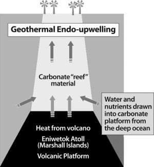
Figure 9. How geothermal endo-upwelling might explain thick “reef” accumulations since the time of the Flood. The process is explained in the text.
Here is a possible scenario of how the Eniwetok Atoll may have become so thick in the few thousand years since the Flood (figure 9). The reef began as a volcanic platform. Carbonates (limestones) began to accumulate on the platform as the result of bacteria and other organisms that can precipitate calcite, especially in volcanically warmed water. This produced much of the “soft, fine, chalky limestone” found within the reef. Carbonate-producing organisms (like corals) were brought to the platform as small larval forms, transported by ocean currents. This explains the occasional occurrence of various corals and mollusks found within the deeper parts of the drill core. The volcanic heat source allowed the carbonate mound to grow, deep below sea level, and the process of geothermal endo-upwelling to begin. The combination of nutrient supply and heat may have allowed the carbonate mound to grow much faster than observed coral reef growth rates today. As the carbonate mound approached sea level, shallow water reef corals were permanently established and thrived as a result of the upwelling process.
Concluding Remarks
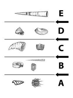
Figure 10. Today, conventional geologists still believe that the earth is millions of years old. However, they believe that individual rock layers may represent short periods of time, or “events.” So where do they put all of the time? The time is placed in between the layers (at the arrows). Each event (A, B, C, D, E) represents a short period of time, but each arrow represents a long period of time, or “hiatus.” During the hiatus, either perfectly flat erosion levels the surface before the next event (removing accumulated deposits), or nondeposition occurs over millions of years.
Many modern geologists realize that most rocks contain evidence of rapid accumulation. However, the idea that the earth is millions of years old is still a common belief. So if the time is not within the rocks, where is it? Many believe the time is within the “cracks” or “hiatuses” between the rocks (see figure 10). Derek Ager, who was not friendly toward creationist ideas, explained it like this: “The history of any one part of the earth, like the life of a soldier, consists of long periods of boredom and short periods of terror.”43 He viewed most of the physical rock record as accumulating quickly (i.e., “the short periods of terror”) and the breaks in between rock layers representing long periods of time (i.e., “the long periods of boredom”). In other words, the “breaks” or “cracks” are where most of the time is placed. The belief then is that these surfaces represent either long periods of nondeposition or surfaces of perfectly flat erosion. But both of these propositions have problems. For example, if a surface is exposed for long periods of time, why don’t organisms churning through the mud extensively disturb the sediments below the surface? In observational studies, it is estimated that bottom-dwelling organisms can rework the annual sediment accumulation several times over!44
This chapter has only examined a few processes in geology that are assumed to take long periods of time. There are many more issues that could be addressed. Today, ideas of uniformitarianism are fading quickly in geology. In fact, many conventional geologists would like to abandon the idea of uniformitarianism altogether, although they are careful not to advocate biblical catastrophism.45
Conventional geologists are recognizing that catastrophic processes can form many parts of the geologic record, and this is being widely reported in the literature.46 The eventual nemesis will be time. Time will continue to be placed in between the rocks, not because there is evidence for it, but that is the only place left for it.47 Conventional geological paradigms demand long periods of time be accounted for, whether there is evidence for it or not.
The New Answers Book 2
People complain about The New Answers Book. They say that it’s so good at giving short, substantive answers that they want more. Well, we listened! In The New Answers Book 2 you’ll find 31 more great answers to big questions for the Christian life. Many view the original New Answers Book as an essential tool for modern discipleship. Both of these books answer such questions as: Can natural processes explain the origin of life? Can creationists be real scientists? Where did Cain get his wife? Is evolution a religion? and more!
Read Online Buy BookFootnotes
- “The Clock in the Rock,” Creation, June 1997, p. 6.
- “Sparking Interest in Rapid Rocks,” Creation, September 1999, p. 6.
- “Keys to Rapid Rock Formation,” Creation, December 1994, p. 45.
- “ ‘Fossil’ Hat,” Creation, June 1995, p. 52.
- Tas Walker, “Petrified Flour,” Creation, December 2000, p. 17.
- K.A. Rasmussen, I.G. Macintyre, L. Prufert, and V.V. Romanovsky, “Late Quaternary Coastal Microbialites and Beachrocks of Lake Issyk-Kul, Kyrgyzstan; Geologic, Hydrographic, and Climatic Significance,” Geological Society of America Abstracts with Programs 28, no. 7 (1996): 304.
- J.A.M. Kenter, P.G. Della, and P.M. Harris, “Steep Microbial Boundstone-dominated Platform Margins; Examples and Implications,” Sedimentary Geology 178, no. 1-2 (2005): 5–30.
- For example, see P.W. Lipman and D.R. Mullineaux, eds., The 1980 Eruptions of Mount St. Helens, Washington, U.S. Geological Survey Professional Paper 1250 (Washington, D.C.: United States Government Printing Office, 1981).
- S.A. Austin, ed., Grand Canyon: Monument to Catastrophe (Santee, CA: Institute for Creation Research, 1994), p. 284; H.G. Coffin, “Erect Floating Stumps in Spirit Lake, Washington,” Geology 11 (1983): 298–299.
- S.A. Austin, “Mt. St. Helens and Catastrophism,” Impact, July 1986, online at www.icr.org/article/261/. Laminations are thin layers of sediment, usually a few millimeters or less.
- J.H. Whitmore, “Experimental Fish Taphonomy with a Comparison to Fossil Fishes,” (PhD diss., Loma Linda, CA: Loma Linda University, 2003).
- D.A. Woolley, “Fish Preservation, Fish Coprolites and the Green River Formation,” TJ 15, no. 1 (2001): 105–111.
- J.H. Whitmore, “The Green River Formation: A Large Post-Flood Lake System,” Journal of Creation 20, no. 1 (2006): 55–63.
- Abrasion is wearing away of bedrock by particles that are being carried in the water or along the stream bottom. As rocks and sand are being carried along, they grind away the bedrock on the stream bottom. The process is similar to smoothing a piece of wood with sandpaper.
- Hydraulic action is erosion of bedrock by the shee r force or energy of the water. Water moving at great speeds can work its way into cracks and force rocks apart, can slam boulders against a cliff face, causing rocks to crumble, and can pluck large pieces of bedrock from the stream bottom.
- Cavitation is erosion by exceedingly rapidly moving water that creates vacuum bubbles as it flows across imperfections or depressions in a bedrock surface. As the vacuum bubbles implode (collapse violently in on themselves), they can destroy the bedrock below them, acting like sledgehammer blows. Cavitation has been known to quickly deteriorate bedrock, cement, and even steel. For example, rapidly rotating submarine propellers can create vacuum bubbles that destroy the propeller and the rudder behind it, removing large chunks of steel. A concrete spillway tunnel was damaged by cavitation in the Glen Canyon Dam in 1983. Cavitation produced a 32- x 40- x 150-foot hole in the bottom of a 40-foot diameter, 3-foot thick, steel-reinforced concrete spillway (Austin, Grand Canyon: Monument to Catastrophe, p. 104–107).
- The Scablands are a whole series of deep, abandoned canyons, hundreds of feet deep, cut into hard, basaltic bedrock.
- See the following papers by JH. Bretz all in the Journal of Geology, “The Channeled Scablands of the Columbia Plateau,” 31 (1923): 617–649; “Alternative Hypothesis for Channeled Scabland I,” 36 (1928): 193–223; “Alternative Hypothesis for Channeled Scabland II,” 36 (1928): 312–341; “The Lake Missoula Floods and the Channeled Scabland,” 77 (1969): 505–543.
- An excellent creationist summary on the formation of the Channeled Scabland region can be found in M.J. Oard, “Evidence for Only One Gigantic Lake Missoula Flood,” Proceedings of the Fifth International Conference on Creationism, ed. R.L. Ivey Jr. (Pittsburgh, PA: Creation Science Fellowship, 2003), p. 219–231.
- For example, see I.P. Martini, V.R. Baker, and G. Garzen, eds., Flood and Megaflood Processes and Deposits: Recent and Ancient Examples, Special Publication 32, International Association of Sedimentologists (Oxford: Blackwell Science, 2002).
- Austin, Grand Canyon: Monument to Catastrophe, p. 83–110. Whitmore and Austin discussed and independently originated this idea in 1985, while Whitmore was a graduate student at ICR. The first person to originate this idea may have been E. Blackwelder in 1934 (GSA Bulletin, v. 45, p. 551–566).
- N. Meek and J. Douglass, “Lake Overflow: An Alternative Hypothesis for Grand Canyon Incision and Development of the Colorado River” in Colorado River Origin and Evolution, eds. R.A. Young and E.E. Spamer, Proceedings of a Symposium held at Grand Canyon National Park in June 2000 (Grand Canyon, AZ: Grand Canyon Association, 2001), p. 199–204.
- R.J. Dorsey, A. Fluette, K. McDougall, B.A. Housen, S.U. Janecke, G J. Axen and C.R. Shirvell, “Chronology of Miocene-Pliocene Deposits at Split Mountain Gorge, Southern California: A Record of Regional Tectonics and Colorado River Evolution,” Geology 35, no. 1 (2007): 57–60.
- Austin, Grand Canyon Monument to Catastrophe, p. 104.
- An expanded version of this section can be found in Whitmore, “Fossil Preservation,” in Rock Solid Answers: Responses to Popular Objections to Flood Geology, eds. M.J. Oard and J.K. Reed (Green Forest, AR: Master Books, in press).
- For good reviews of the literature see S.M. Kidwell and K.W. Flessa, “The Quality of the Fossil Record: Populations, Species, and Communities,” Annual Reviews of Ecology and Systematics 26 (1995): 269–299; or P.A. Allison and D.E.G. Briggs, eds., Taphonomy: Releasing the Data Locked in the Fossil Record (New York: Plenum Press, 1991).
- C.E. Brett and A. Seilacher, “Fossil Lagerstätten: A Taphonomic Consequence of Event Stratification,” in Cycles and Events in Stratigraphy, eds. G. Einsele, W. Ricken, and A. Seilacher (Berlin: Springer-Verlag, 1991), p. 283–297.
- A.K. Behrensmeyer, F.T. Fursich, R.A. Gastaldo, S.M. Kidwell, M.A. Kosnik, M. Kowalewski, R.E. Plotnick, R.R. Rogers, and J. Alroy, “Are the Most Durable Shelly Taxa also the Most Common in the Marine Fossil Record?” Paleobiology 31 (2005): 607–623.
- K.P. Wise, “The Pre-Flood Floating Forest: A Study in Paleontological Pattern Recognition,” in Proceedings of the Fifth International Conference on Creationism, ed. R.L. Ivey Jr. (Pittsburgh, PA: Creation Science Fellowship, 2003), p. 371–381.
- Many experiments in “artificial coalification” have been carried out. A few examples are: W.H. Orem, S.G. Neuzil, H.E. Lerch and C.B. Cecil, “Experimental Early-stage Coalification of a Peat Sample and a Peatified Wood Sample from Indonesia,” Organic Geochemistry 24, no. 2 (1996): 111–125; A.D. Cohen and A.M. Bailey, “Petrographic Changes Induced by Artificial Coalification of Peat: Comparison of Two Planar Facies (Rhizophora and Cladium) from the Everglades-mangrove Complex of Florida and a Domed Facies (Cyrilla) from the Okefenokee Swamp of Georgia,” International Journal of Coal Geology 34 (1997): 163–194; S. Yao, C. Xue, W. Hu, J. Cao, C. Zhang, “A Comparative Study of Experimental Maturation of Peat, Brown Coal and Subbituminous Coal: Implications for Coalification,” International Journal of Coal Geology 66 (2006): 108–118.
- J.K. Warren, Evaporites: Their Evolution and Economics (Oxford: Blackwell Science, 1999).
- M. Hovland, H.G. Rueslåtten, H.K. Johnsen, B. Kvamme and T. Kuznetsova, “Salt Formation Associated with Sub-surface Boiling and Supercritical Water,” Marine and Petroleum Geology 23 (2006): 855–869.
- If something is not very soluble, it means that it can’t dissolve easily, or it will come out of solution easily and form a solid precipitate.
- An expanded version of this section can be found in: Whitmore, “Modern and Ancient Reefs,” in Rock Solid Answers: Responses to Popular Objections to Flood Geology, eds. M.J. Oard and J.K. Reed (Green Forest, AR: Master Books, in press).
- P. Read and A. Snelling, “How Old Is Australia’s Great Barrier Reef?” Creation Ex Nihilo, November 1985, p. 6–9.
- An atoll is a circular reef with a central lagoon that rises from the deep ocean floor, not the continental shelf like the Great Barrier Reef of Australia. It has been documented that most atolls sit on volcanic pedestals.
- H.S. Ladd and S.O. Schlanger, “Drilling Operations on Eniwetok Atoll,” U.S. Geological Survey Professional Paper 260-Y (1960): 863–903.
- D.E. Wonderly, God’s Time-Records in Ancient Sediments (Hatfield, PA: Interdisciplinary Biblical Research Institute, 1977, reprinted in 1999 with minor corrections).
- A.A. Roth, Origins, (Hagerstown, MD: Review and Herald Publishing Association, 1998), p. 237.
- S.A. Earle, “Life Springs from Death in Truk Lagoon,” National Geographic 149, no. 5 (1976): 578–603.
- H.E. Fox, “Rapid Coral Growth on Reef Rehabilitation Treatments in Komodo National Park, Indonesia,” Coral Reefs 24 (2005): 263.
- F. Rougerie and J.A. Fagerstrom, “Cretaceous History of Pacific Basin Guyot Reefs: A Reappraisal Based on Geothermal Endo-upwelling,” Palaeogeography, Palaeoclimatology, Palaeoecology 112 (1994): 239–260; A.H. Saller and R.B. Koepnick, “Eocene to Early Miocene Growth of Eniwetok Atoll: Insight from Strontium-isotope Data,” Geological Society of America Bulletin 102, no. 3 (1990): 381–390.
- D.V. Ager, The Nature of the Stratigraphical Record, 2nd edition, (London: MacMillan Press, 1981), p. 106–107.
- D.C. Rhoads, “Rates of Sediment Reworking by Yoldia limatula in Buzzards Bay, Massachusetts, and Long Island Sound,” Journal of Sedimentary Petrology 33, no. 3 (1963): 723–727.
- K.J. Hsü, “Actualistic Catastrophism,” Sedimentology 30 (1983): 3–9; P.D. Krynine, “Uniformitarianism Is a Dangerous Doctrine,” Journal of Sedimentary Petrology 26, no. 2 (1956): 184; J.H. Shea, “Twelve Fallacies of Uniformitarianism,” Geology 10 (1982): 455–460.
- W.A. Berggren and J.A. Van Couvering, eds., Catastrophes and Earth History; the New Uniformitarianism (Princeton, NJ: Princeton University Press, 1984). This book is a collection of 18 essays. Note especially the essays by S.J. Gould (chapter 1) and D.V. Ager (chapter 4).
- One example of an attempt to place time in between rock layers is carbonate hardgrounds. These are hardened cement-like surfaces that occur on the ocean floor. It is often claimed these surfaces occur in the rock record, too, and represent surfaces where long periods of time passed. Creationists have recently begun to address hardgrounds at a classic site in Ohio: J. Woodmorappe, and J.H. Whitmore, “Field Study of Purported Hardgrounds of the Cincinnatian,” TJ 18, no. 3 (2004): 82–92, 2004; J. Woodmorappe, “Hardgrounds and the Flood: The Need for a Re-evaluation,” Journal of Creation 20, no. 3 (2006): 104–110.
Recommended Resources

Answers in Genesis is an apologetics ministry, dedicated to helping Christians defend their faith and proclaim the good news of Jesus Christ.
- Customer Service 800.778.3390
- © 2024 Answers in Genesis


