
What Is Unique About the Colorado River?
Why, according to evolutionists, would rivers other than the Colorado River not form canyons? Dr. Andrew Snelling, AiG–U.S., responds.
I did do a bit of searching on your site about my inquiry, but didn’t find an exact answer. Perhaps it will be a question you will find time to answer.
If evolutionists believe that the Grand Canyon was formed by the Colorado River, why don’t rivers like the Mississippi, Missouri or the Ohio also have some form of canyon?
Thank you,
Dan White
Dear Mr. White,
Your question required some thinking about the geology of North America and the timing of its different components within the passage of the Flood year. That was going to be the key to providing you a satisfactory answer.
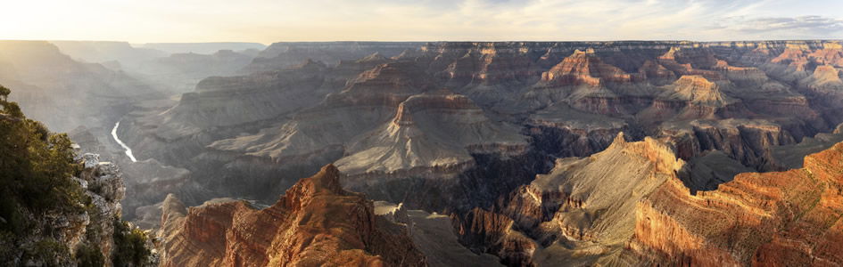
The best way to understand the answer to this question is to start by looking at the Colorado River, the Grand Canyon, and the plateau into which the Grand Canyon is carved. The layers exposed in the walls of the Grand Canyon were deposited early during the Flood. Many of these layers can be traced right across North America, some of them even outcropping in the Appalachians. But the Flood deposition in the Grand Canyon area continued on through the Flood with more layers being deposited that are now exposed to the north of the Grand Canyon as a sequence of colored cliffs. These cliffs are exposed in places like Zion National Park (the white cliffs) and higher up at Bryce Canyon National Park (the pink cliffs). This sequence of rock layers, which spans much of the Flood year of deposition, is illustrated and described in my Answers magazine article titled “Order in the Fossil Record.”1
When the floodwaters retreated, they completely stripped away many of the top rock layers from the North and South Rim areas of what is now the Grand Canyon. We know those layers were originally right across that area because in places there are thin remnants of them, such as the Moenkopi Formation and the lower part of the Chinle Formation capped by recent basalt at Red Butte, 16 miles south of the Grand Canyon. At the same time as the waters were retreating, the area which is now the Colorado Plateau was pushed up by earth movements. This included the plateau area that now forms the surface to the north and south of the rims of the Grand Canyon. While there was some residual gully erosion across the surface of that plateau as the last of the floodwaters retreated, it ended up being an essentially flat surface. Additionally, when the floodwaters retreated, some of them were trapped in lakes dammed up behind these uplifted plateaus. Those lake waters eventually eroded through the “dam walls” after the Flood, in many cases draining catastrophically and leaving behind cliffs like those of Bryce Canyon and Zion National Parks.
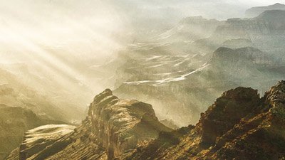
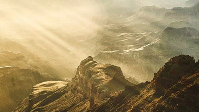
This was linked to what happened in the Grand Canyon area. The plateau there as it rose also blocked floodwaters further inland in what are now the headwaters of the Colorado River from escaping westwards toward the Pacific Ocean. So, the plateau effectively became a natural dam wall, and the waters backed up behind it in a huge lake system. Even secular scientists recognize remnants of this lake system.2 Of course, there was continuing rain after the Flood. In fact, climate modeling suggests that with the oceans being warmer after the Flood, huge hurricane systems developed over the oceans. When these storms moved landward, they dumped tens of inches of rain in massive storms over several days.3
Consequently, with such rainfall in the Southwest the water level in the lake system behind the natural plateau dam wall quickly rose until it was lapping the top of the plateau. Of course, within the plateau itself were porous limestones through which water in the lake system would begin to percolate, further corroding out caverns that can now still be seen in some of the limestones. So then, when the water level started to flow over the top of the plateau, it first utilized any gullies across the surface of the plateau. Then because the limestones had been weakened, as more water flowed over the natural dam wall, erosion got faster and faster in cutting a swathe through the plateau so that in a short period of time a lot of water carved out the Grand Canyon. All of these details and more, including explanatory diagrams, are available in the chapter in the New Answers Book 3 titled “When and How Did the Grand Canyon Form?” (pages 173–185).
So why is the Grand Canyon where it is, and why is the Grand Canyon so unique among all the world’s canyons? There are other big and deep canyons elsewhere in the world, but none of them reach the scale of the Grand Canyon of northern Arizona. This is because there was a unique conjunction of geological features and events. Not only was there a thick sequence of rock layers deposited by the Flood, but the plateau was pushed up at the time the floodwaters were receding, and the plateau formed that natural dam wall. The catastrophic failure of that dam wall because of the waters backed up behind it caused a lot of water in a little bit of time to carve out the Grand Canyon.
Now let’s go to other parts of the USA and look at the Mississippi, Missouri, and Ohio Rivers. Why don’t they flow through canyons the scale of the Grand Canyon? The answer is simple. There is not as much relief! Most of Ohio and Kentucky are only 1,000 feet above sea level. Deep canyons can only be cut in areas with a significant elevation difference from the river’s base level. There are no deep canyons along the Ohio and Mississippi Rivers because there is not enough relief (the difference in elevation from high spots to low spots). There just was not the same unique conjunction of geological circumstances happening in these river systems in the same way as in northern Arizona.
The Ohio River has its headwaters in the Appalachians, and some of its tributaries do flow through deep valleys. However, in the Appalachians and through much of the area where the Ohio River flows, the exposed rocks are only those from the lower part of the Flood sequence. Furthermore, the Appalachians were not formed at the end of the Flood, at the same time the plateau did through which the Grand Canyon was carved. Rather, the Appalachians were formed halfway through the Flood from rocks deposited early in the Flood being crumpled and faulted as a result of giant mass movements caused by continental plate collisions catastrophically.
So as the Flood progressed, instead of more layers being deposited throughout the eastern United States, the Appalachians and surrounding areas started to be eroded. And when the floodwaters retreated, that erosion continued, with no plateau pushed up to form a dam wall to block any waters. There was no lake system behind any natural dam wall that could then burst through and carve out another grand canyon with a lot of water in a little bit of time. Instead, the water quickly drained off the area to continue the erosion that had already begun during the Flood, deepening the valleys in the Appalachians and then meandering across the deeper eroded flat topography to the west.
Whereas the headwaters of the Mississippi and Missouri Rivers are in different areas to the north and northwest, the “story” is much the same. Except in the case of the headwaters of the Missouri where there are some deep canyons—for example, in Yellowstone National Park—there was not the same unique conjunction of geological and Flood process circumstances to duplicate along the Mississippi River and the rest of the Missouri River what happened out in northern Arizona. Again, the headwaters were in mountainous areas that formed at different times during the Flood, and as the floodwaters drained off those headwaters areas eroding the countryside, there was also no plateau pushed up there that would create a natural dam wall to block waters and form lake systems. So there was no similar catastrophic failure of a natural dam that would have allowed a lot of water in a little bit of time to carve out large canyons in those river systems. Instead, as in the case of the Ohio River, the Missouri and Mississippi followed the path of where the retreating floodwaters eroded their way across the middle of the continent southwards across what had become an essentially eroded flat topography.
So I hope these details, though broad scale and broad brush, help answer the question for you. There was a unique set of circumstances that made the Grand Canyon happen where it did, and the Colorado River today is there because the Grand Canyon was carved out first across the plateau. And so it is with the other rivers. They are where they are today because the water flow we see today is a remnant of the much larger volume of flow that occurred at the closing stages of the Flood as the floodwaters drained off the emerging North American continent back into new ocean basins produced during the Flood. So the river systems are governed by the rocks they eroded through at the time and the topography produced by the earth movements during the Flood. The net result is that each river system is unique in itself, though many have similar features, while the Grand Canyon is one of a kind.
I hope these brief comments are a help. Our understanding of the Flood—how it happened in the past as described in God’s Word—is what informs us of how these present-day rivers are where they are. Thanks for your question.
Yours sincerely in Christ,
Dr. Andrew Snelling
Footnotes
- The January–March 2010 issue, pages 64–68.
- R.A. Young and E.E. Spamer (eds.), 2004, The Colorado River: Origin and Evolution, Monograph no. 12, Grand Canyon Association, Grand Canyon AZ; and W. Ranney, 2005, Carving Grand Canyon: Evidence, Theories, and Mystery, Grand Canyon Association, Grand Canyon AZ.
- L. Vardiman, 2003, Hypercanes following the Genesis Flood, in Proceedings of the Fifth International Conference on Creationism, R. L. Ivey, Jr. (ed.), pp. 17–28, Pittsburgh, Pennsylvania: Creation Science Fellowship.

Support the creation/gospel message by donating or getting involved!

Answers in Genesis is an apologetics ministry, dedicated to helping Christians defend their faith and proclaim the good news of Jesus Christ.
- Customer Service 800.778.3390
- Available Monday–Friday | 9 AM–5 PM ET
- © 2025 Answers in Genesis