Plate Tectonics—The Reality Behind a Theory
Geology
The idea that continents move sounds crazy . . . until you look at the facts.
One of the most incredible claims of modern science is that continents move. When Alfred Wegener proposed a version of this theory in 1912, fellow scientists accused him of “pseudoscience,” “delirious ravings,” and suffering from “moving crust disease.” Now that his theory is widely accepted, most schoolbooks and museums present it simply as fact, without detailed justification.
Christians need to be careful of both extremes, especially on a topic so central to our understanding of earth history. Just because evolutionists developed a theory doesn’t make it wrong, but scientific “consensus” doesn’t mean we should blindly accept everything they say without some fact-checking.
No one wants to sound like Wegener’s original close-minded, shrill opponents. If we’re not careful, educated people may ignore anything we say, including what we say about the Bible’s history, Christ, and the gospel.
This isn’t just an intellectual exercise. Digging a little deeper provides immense rewards for our witness. It shows that Christians embrace the best of science. And more important, it shows the power of the Bible’s Flood account to help us better understand our world.
A Strange Pattern That Demands Explanation
Have you ever wondered why some of the most powerful earthquakes strike places like southern California but leave other regions unscathed? Why do active volcanoes explode in the Pacific Northwest but skip the Midwest? Similar patterns are repeated around the globe and demand an explanation. They are important clues indicating that the earth's surface really does move.
Most of the world’s active volcanoes occur in linear belts that coincide with earthquake zones. This is especially obvious at the outer edge of the Pacific Ocean. Volcanoes are so plentiful here that this circle is called the “Ring of Fire.” Active volcanoes belch out steam, ash, and lavas from the upwelling of hot molten rock (called magma) from inside the earth. Why are so many volcanoes here and not elsewhere?
Not only do earthquakes track around the rim of the Pacific Ocean, they also encircle the globe in an interlinked pattern. A line of earthquake zones runs down the center of the Atlantic Ocean and then east into the Indian Ocean, where it splits in two, one branch heading northward towards Arabia, and the other branch heading eastward into the Pacific Ocean. Clearly something is happening at these special zones.
Evidences of Plate Movement
Geologists believe that this interlinked pattern of earthquake zones and active volcanoes marks the edges of “plates” that divide the earth’s outer skin, or crust, into more than a dozen pieces. (Strictly speaking, the plates include the uppermost mantle beneath the crustal pieces.) They claim that the movements of these plates cause earthquakes and volcanoes. But do they have any evidence?
Satellites Measure Ground Movement
With the advent of satellite technologies, scientists can now measure precise movements of land on both sides of the plate boundaries. A network of base stations sends signals up to the satellites, which show that the plates are indeed moving, albeit at a snail’s pace of inches per year (about the same pace that fingernails grow).
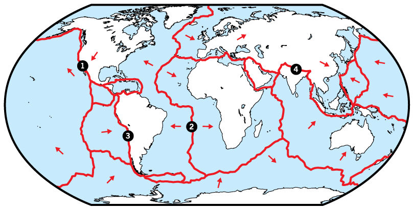
The study of earth movements is technically known as “tectonics,” so the study of plate movements is called “plate tectonics.” (Note that it is no longer accurate to call it “continental drift.” We now know that the ocean floor crust is also moving. In fact, the Pacific, Nazca, Cocos, and Scotia plates are moving even though they consist almost entirely of ocean floor crust. See Figure 1.)
But do these plate movements cause volcanoes and earthquakes?
Chemical Tests of Lava Show Ocean Crust Moving Under Continental Crust
Perhaps you never realized it, but the earth has two different types of crust. When ocean vessels began sampling the ocean floor in the 1960s, scientists realized how different the ocean crust was from the continents’ crust. If the ocean crust was moving under the continental crust, scientists suspected they might find evidence in the lavas rising up onto the continents’ surfaces.
Plate tectonics give us insights as to what likely happened during the global Flood.
The differences are very distinct. The continents are made up of many different rock types, but if we were to grind them all up, the average composition would be similar to granite. On the other hand, drilling into the ocean floors has revealed that the oceanic crust beneath the ooze is made up of basalt (dark volcanic rock). Granites contain a lot of silicon and not so much iron and magnesium, whereas basalts contain a lot less silicon but much more iron and magnesium.
Cooled oceanic crust is heavier than the hot mantle beneath it. So it tends to sink. The continental crust, in contrast, is much lighter (less dense), so it floats. As a result, the continents “ride” higher than the ocean crust. If they collide, the ocean crust would slide under the continental crust because it is heavier.
The high pressure and temperature in a collision would cause a melting reaction that would ultimately send hot magma from the upper mantle toward the surface. Scientists have checked the chemistry of many lavas on the edges of continents and found that they are generally mixtures of ocean basalt rock and continental granitic rocks, producing intermediate rocks called andesites and dacites.
Evidence of Four Types of Plate Boundaries
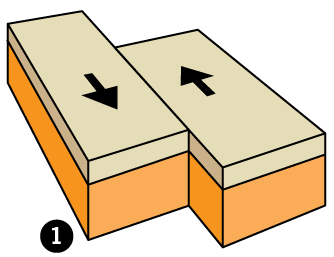
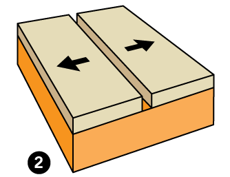
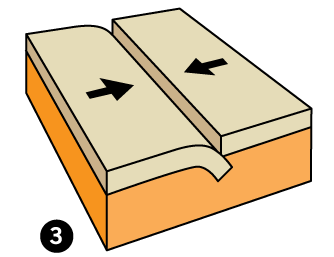
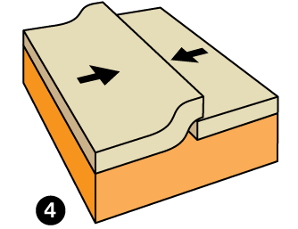
If the crustal plates are jostling against one another, they should do so in one of four ways: pulling apart, colliding in two ways, or sliding past each other (Figure 1). Geologists have found evidence of all four.
Pulling Apart
Wherever oceanic plates are pulling apart, geologists would expect to find lava that rose from the uppermost mantle beneath the rift to produce new oceanic crust. The best example is the boundary down the middle of the Atlantic Ocean. The rifting has produced a topographic feature known as the Mid-Atlantic Ridge. When scientists tested the lava in this region, they found it matches typical oceanic crust.
Colliding
Plates also push against, or collide into, one another. This has two results.
If two continental plates collide, they buckle and crumple in the collision zone to produce mountains. The best example is the Himalayas. Here geologists find lower continental crust material (granites) intruded into buckled metamorphosed sedimentary layers.
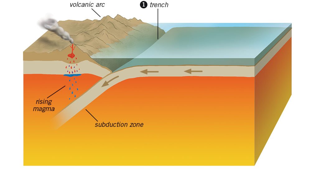
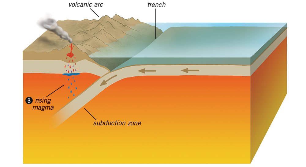
If an oceanic plate collides with a continental plate, it is pushed down underneath the edge of the continental plate (technically known as subduction). One of the best-known examples is off the coast of Peru and Chile. Here the Nazca plate is being pushed down under the South American plate. The result is the Andes Mountains. Here geologists find lavas that are a mixture of oceanic and continental crust material (called andesite).
Sliding Past Each Other
The fourth possible interaction is plates sliding past one another. Here geologists find earthquakes but not volcanoes. The most infamous example is the San Andreas Fault of southern California, the boundary between the Pacific and North American plates. Every time these plates move along that fault zone, devastating earthquakes result.
Evidence of Seafloor Spreading
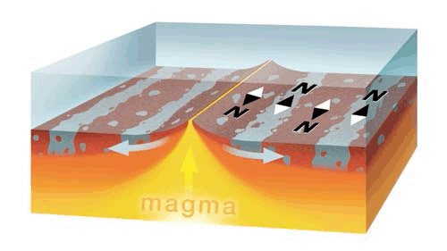
Since scientists weren’t present to study the original lavas when they flowed out of mid-oceanic ridges, how do they know the lavas came from the boundary between two plates and then pushed the plates in opposite directions? Scientists found the lavas had formed a unique pattern when they cooled, known as magnetic “stripes” (Figure 2).
It’s a bit complicated, but here is how it basically works. It appears that in the past the earth’s magnetic field changed direction. So when each new surge of seafloor basalts upwelled and cooled, it should have recorded a different magnetic field direction. This is possible because basalts contain magnetic iron in a mineral called magnetite. When the magma cools, regions within the magnetite crystals (called magnetic domains) align themselves with the magnetic field and “freeze” into the rock, recording the direction of the earth’s magnetic field at that time.
When oceangoing research vessels first towed recording devices across the ridge in the 1960s, they found this pattern of magnetic “stripes.” The pattern was the same on either side of the ridge, providing powerful evidence of seafloor spreading.
Other Evidences of Earth Movements
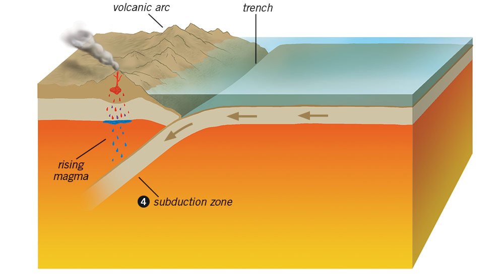
There are many other amazing evidences of earth movements. One is the existence of deep-sea trenches at the subduction zones. We find these trenches where oceanic plates are sliding under continental plates (Figure 3). One of the most famous trenches occurs where the Pacific plate is being pushed under the Eurasian plate off Japan’s coast. The sinking plate has folded and dragged the seafloor down to form a deep trench. Every time this seafloor moves, it generates a massive earthquake. Making matters worse, the seafloor movements also jolt the ocean water above, generating tsunamis which sweep across the ocean and over the coast. These tsunamis result in horrifying devastation, such as the 2011 tsunami that killed 19,000 people and caused $300 billion in damage along Japan’s coast.
Another evidence of plate movements is the ability of seismic recorders to pinpoint the positions of the movements under the earth’s surface, precisely where their movements and collisions should be generating earthquakes. In subduction zones, seismologists proved that deep earthquakes originate precisely where the upper surfaces of the subducting plates are pushing against both the upper plates and the mantle beneath. This confirms that subduction is occurring.
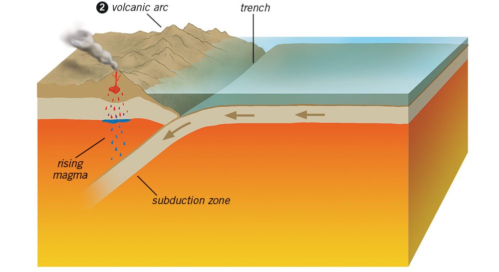
Further evidence is the “volcanic arcs” next to trenches. If plates are sinking, the higher temperature deeper in the earth and the friction of the subducting plates should generate enough heat to melt rocks, both at the top of the sinking plate and within the mantle above it. This magma should rise to the surface and erupt through volcanoes. As expected, an arc of volcanoes does rise parallel to each offshore trench. In fact, the Japanese islands were largely built by volcanic eruptions next to a deep-sea trench.
Another amazing prediction of plate tectonics is the existence of the plate that drove into the western edge of North America, pushing up the Rocky Mountains and then disappearing under the continent. Scientists predicted this plate should have sunk deep into the mantle under western North America. They were able to test their prediction after the development of seismic tomography (using seismic waves to make a 3D image of the earth’s interior). As expected, they found the missing plate, known as the Farallon plate, deep in the mantle.
Plate Formation During the Flood
These are only a few of the many features plate tectonics explains. Just as exciting, it gives us insights into what likely happened during the global Flood judgment of Noah’s day.
Genesis 7:11 says the Flood began with the breaking up of “the fountains of the great deep.” This catastrophic bursting of hot waters and upwelling molten rock would have caused a massive rift in the seafloor (“the great deep”). Such rifting would have rapidly spread around the globe, including across the pre-Flood supercontinent, tearing it apart to make today’s continents.
Shortly thereafter, the cold pre-Flood ocean crust would have started to sink, being subducted under the less dense continental crust, which continued to “float.” Creation scientist John Baumgardner has shown that plate movements would have been extremely fast during the Flood event, compared to what we observe today. Most of the continents were moved by seafloor spreading and runaway subduction during the Flood year. Today, we merely see residual movements of the plates, but enough to powerfully explain where all the earthquakes, active volcanoes, mid-ocean ridges, and deep-sea trenches occur on earth.
As we share the warnings of God’s Word with a skeptical generation, we have no reason to fear we will sound pseudoscientific. Plate movements, earthquakes, and volcanic eruptions are still occurring today and remind us that we suffer under the aftereffects of God’s global Flood judgment on human wickedness. People need to hear Jesus’ warning that, as it was in the days of Noah, so shall it be in the day of His second coming, when He will judge the earth a second time, not by water but by fire (Luke 17:26-30).
Answers Magazine
January–March 2016
Discover the role of ancient Near Eastern writings in understanding Scripture and learn about some exotic animals that can only be explained by a Creator.
Browse IssueRecommended Resources

Answers in Genesis is an apologetics ministry, dedicated to helping Christians defend their faith and proclaim the good news of Jesus Christ.
- Customer Service 800.778.3390
- Available Monday–Friday | 9 AM–5 PM ET
- © 2026 Answers in Genesis


