
NASA, the Changing Size of North America, and the Flat Earth
As I’ve written previously, flat-earthers deny that there are any satellites or astronauts. There is no International Space Station (ISS), and we haven’t landed on the moon. So all those photos and videos of astronauts in space must have been faked. What do flat-earthers think of NASA? Obviously not much. Flat-earthers must insist that NASA is a sham organization that has lied about everything it has supposedly done. Flat-earthers spend considerable time and effort attempting to debunk all things from NASA. Though their arguments are many, in this article I will take up just two complaints.
What’s in a Name?
Take NASA’s name, for instance. Flat-earthers claim that in Hebrew, the word nasa means to deceive. Hence, this proves that from its founding, NASA admitted in plain sight that it deceives people. Only on the campy 1960s Batman TV show would such an outrageous clue make any sense. Several Hebrew words in the Bible are translated as “deceive” or some derivative thereof. The intended Hebrew word here is nasha’, which appears 15 times in the Old Testament. Twelve times nasha’ is translated “deceive” or “deceived” (2 Kings 18:29, 19:10; 2 Chronicles 32:15; Isaiah 19:13, 36:14, 37:10; Jeremiah 4:10 [twice for emphasis so that it is translated “greatly deceived”], Jeremiah 29:8, 37:9, 49:16; Obadiah 1:3 and 7). In its first appearance (Genesis 3:13 KJV), it is translated as “beguiled.” However, in Psalm 55:15 nasha’ is translated “seize,” and in Jeremiah 23:39, it is translated as “utterly.” Why the difference in these two verses? Probably because of the semantic range and nuance of context. In either case, the meaning clearly isn’t to deceive.
The flat-earther claim that NASA means “to deceive” in Hebrew is a specious argument.
But is there a similarity between NASA and nasha’, and if so, does it imply a connection between the two? Most people use the acronym NASA yet have no idea what NASA stands for (National Aeronautics and Space Administration). Unlike other government agencies, such as the FBI and CIA, we tend to pronounce NASA as a word rather than saying the letters that spell it out. This has lent to our thinking of NASA as a word rather than initials for a government agency. Notice that this has led to pronouncing the first letter A in NASA as a short a and the second letter A as a short e. We pronounce the two consonants as we normally do, with the accent on the first syllable. However, compare that to how the Hebrew word nasha’ is pronounced. The first consonant is pronounced the same way that we say our letter n, but the second consonant is pronounced as sh. Furthermore, both a’s are pronounced as we would say awe. Finally, the accent is on the second syllable, not the first. If most people heard the Hebrew word nasha’ properly pronounced, they wouldn’t make any association with NASA. Therefore, the flat-earther claim that NASA means “to deceive” in Hebrew is a specious argument.
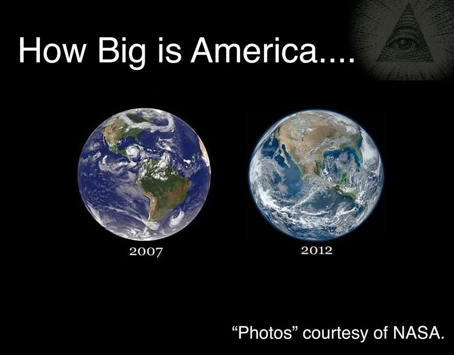
The Changing Size of North America
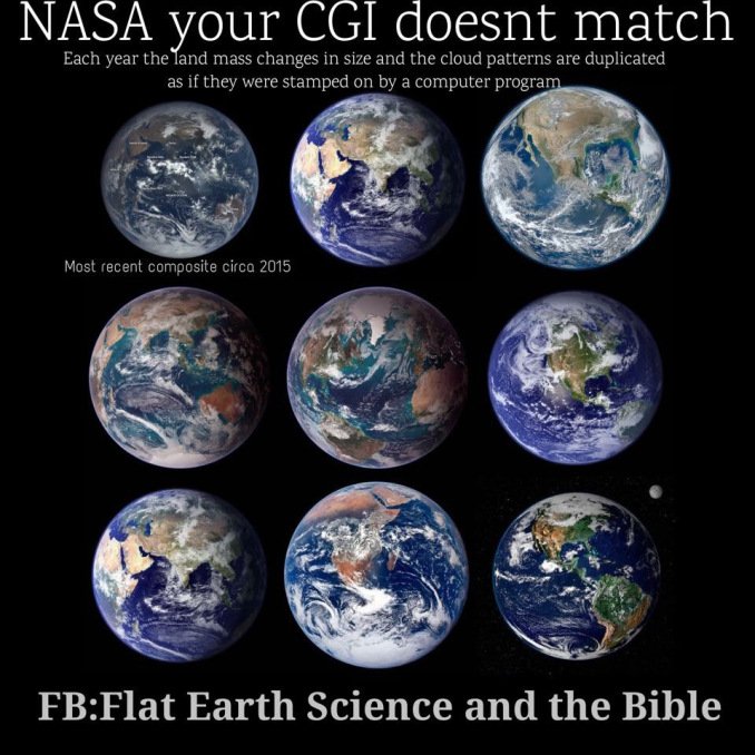
Flat-earthers frequently criticize images taken from space. One claim is that different NASA photos of the earth show surface features having various sizes. An example is the accompanying meme from a flat-earth Facebook page. The three images on the right are photographs of the earth taken at different times. Notice that North America appears in different sizes in the images. Flat-earthers argue that since North America obviously has a fixed size, then if North America has different sizes in the images, NASA must have faked the images. At first glance, this appears to be a good argument—why would North America have different sizes in different images when the earth is the same size in each image? But think about this for a minute: the clever people at NASA supposedly went to great trouble to produce these computer-generated images, but no one on the team noticed that North America kept changing size? That doesn’t make sense.
In search of a more plausible answer, I took these two photographs of a 12-inch diameter globe using a Nikon D3200 camera. For the photograph on the left, I used an AF-S DX NIKKOR 55-200mm f/4-5.6G ED VR II lens zoomed in all the way. I adjusted the distance so that the globe nearly filled the frame vertically. That distance was 16.5 feet from the globe’s center. For the image on the right, I used an AF-P DX NIKKOR 18-55mm f/3.5-5.6G lens, the standard lens that comes with the camera. I zoomed that lens all the way out, which allowed me to get as close as possible to the globe while matching the size of the globe in the image on the left. That distance was 16 inches from the globe. Therefore, the photograph on the left was taken at a distance more than 12 times greater than the photograph on the right, though the globe appears about the same size. For both photographs, the camera was on a tripod adjusted so that the lens was on a horizontal line passing through the center of the globe. Notice that North America appears much larger in the photograph on the right than it does in the photograph on the left. How is that possible?
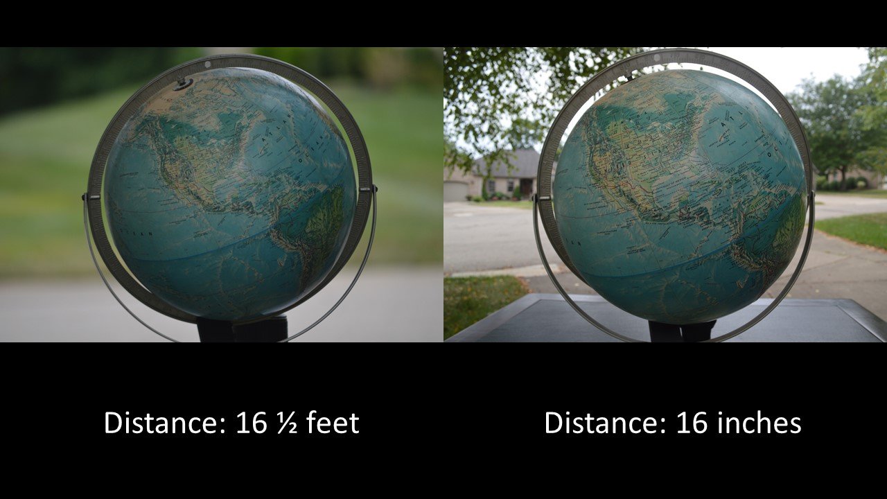
Why North America Looks Different on the Two Photos of My Globe
When you are closer to a globe, you see less of the globe than you do when you are farther away. You can see this by carefully comparing the two photos of my globe. The one on the left shows more surface area than the one on the right. But when we look at any image of a globe, it gives the illusion that we are seeing half the globe’s surface when we are really seeing something less than half. Displaying what we see as the same size completes the illusion. In what follows, I will go into some mathematical detail. If you don’t want to follow those details, skip down to the next section.
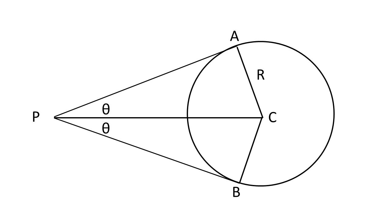
The accompanying figure illustrates the situation. The circle represents the globe. The point P represents the location of the camera lens at the distance PC from the center of the globe. The lines PA and PB are tangent to the globe. Notice that the points on the circle to the right of points A and B are blocked from view at point P. The only points on the circle visible from point P are those points between points A and B on the left side of the circle. That is, less than half the circumference of the circle is visible from point P. This is a two-dimensional representation. In three dimensions, the portion of the globe visible at point P will be the spherical cap inscribed by a cone with its apex at point P having apex angle of 2θ and bounded top and bottom by the lines PA and PB. The result is that less than half of the globe’s surface is visible. Notice that as the distance PC increases, the amount of visible area increases. At a very great distance, the amount of area ought to approach the entire half of the globe facing point P.
Let me quantify this. The lines CA and CB are radii of the globe. Let that radius be R. The triangles PAC and PBC are congruent right triangles. Hence,
sin θ = R/PC
Since the globe is 12 inches in diameter, R = 6 inches. In the photograph on the left, the distance PC = 16.5 feet = 198 inches. Therefore, in the first photograph θ = 1.7 degrees. The area of a spherical cap is
A = 2πR2 (1 - cos θ'),
where θ' is the complement of θ. It may be more instructive to determine how much of the hemisphere facing point P is visible. The area of a hemisphere is 2πR2. Therefore the visible fraction of the hemisphere is given by (1 – cos θ'). For the photograph on the left, that fraction is 0.97. Therefore, 97% of the hemisphere facing the camera is visible. The situation is different for the photograph on the right. For that view, the distance PC = 16 inches, resulting in θ = 22 degrees. The amount of the hemisphere facing the camera that is visible is only 63%.
The problem is that since what we see appears as circles about the same size, our minds incorrectly assume that we are seeing the entire half of the globe in either photograph.
Taking the ratio of those two percentages, it follows that the photograph on the left shows 155% more surface area of the globe than the photograph on the right does. How can this be, given that the globe in either photograph appears to be about the same size? The answer is that the apparent size of the globe is not the same size in the two photographs. Rather, the portion of the globe that is visible appears to be the same size. Remember that what we see is a spherical cap that encompasses less than half the surface of the globe. And the sizes of the spherical caps visible in the two photographs is different. The problem is that since what we see appears as circles about the same size, our minds incorrectly assume that we are seeing the entire half of the globe in either photograph.
Now You See It, Now You Don’t
Examining my two photos above demonstrates that far more area is visible in the left photograph than in the right photograph. In the left photograph, all of North America is visible, including Alaska, part of the Bering Sea, and part of Siberia. But in the right photograph, only a portion of eastern Alaska is visible, with none of the Bering Sea and Siberia visible. In the photograph on the left, we can see the North Pole, all of Greenland, with ocean east of Greenland, as well as Iceland, and parts of Europe, such as the British Isles. But in the right photograph, only part of Greenland is visible, but none of the oceans beyond or any of Europe are visible. In the left photograph, you can see part of Africa, but none of Africa is visible in the right photograph. In the left photograph, you can see South America, except for the extreme southern tip.
You can also see the South Atlantic Ocean east of South America. But in the right photograph, much of southern South America is obscured, as is most of the South Atlantic Ocean. Along the bottom of the left photograph, you can see far south of the Tropic of Capricorn; but in the right photograph, very little south of the Tropic of Capricorn is visible. Continuing around, on the left side of the left photograph, you can see the Hawaiian Islands, as well as the entire word ocean labeling the Pacific Ocean. But in the right photograph, the Hawaiian Islands are not visible, nor are the first two letters of ocean.
Since the globes in the two photographs appear to have the same size, but the photograph on the left contains more surface area of the globe than the photograph on the right, the surface features in the left photograph must appear shrunk compared to those same features in the photograph on the right. This explains why North America appears smaller in the photograph on the left than in the photograph on the right. I have not employed a trick here. The only trick is in our minds when we see the visible portions of the globe presented as the same size, and we assume that we are seeing the entire half of the globe on the same scale. However, when we view a globe from different distances, the portion of the globe that we see is different.
The NASA Photos Don’t Lie After All
In similar manner, the satellite photographs that show varying sizes of terrestrial features at different times come from different spacecraft orbiting at different distances from the earth. Therefore, rather than proving that these photographs have been faked, the changing size of earth’s features proves that the photographs are not faked, because they show exactly what we expect to see if the earth is a globe photographed from different distances. Hence, the flat-earth claim about the changing sizes of features, such as North America, on satellite photos of the earth is false. This is an example of flat-earthers using what appears at first to be a good argument in support of their model. However, like so many other flat-earth claims, it doesn’t stand up to scrutiny.
Support the creation/gospel message by donating or getting involved!

Answers in Genesis is an apologetics ministry, dedicated to helping Christians defend their faith and proclaim the good news of Jesus Christ.
- Customer Service 800.778.3390
- Available Monday–Friday | 9 AM–5 PM ET
- © 2026 Answers in Genesis