
Chapter 26
Why Is Mount St. Helens Important to the Origins Controversy?
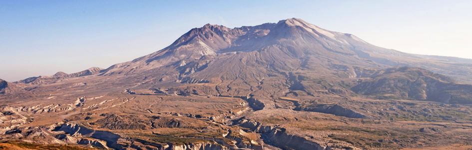
On May 18, 1980, a catastrophic geologic event occurred that not only shocked the world because of its explosive power, but challenged the foundation of evolutionary theory. That event was the eruption of Mount St. Helens in the state of Washington. The eruption of Mount St. Helens is regarded by many as the most significant geologic event of the 20th century, excelling all others in its extraordinary documentation and scientific study. Undeniable facts confront us. Although not the most powerful explosion of the last century, Mount St. Helens provided a significant learning experience within a natural laboratory for the understanding of catastrophic geologic processes.
On May 18, and also during later eruptions, certain critical energy thresholds were exceeded by potent geologic processes. These were able to accomplish significant changes in short order to the landscape (figure 1), providing us a rare, user-friendly opportunity to observe and understand the effects of catastrophic geologic processes.
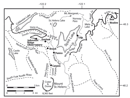
Figure 1. Map of the north flank of the volcano showing areas of special interest to understanding catastrophic geologic processes within Mount St. Helens National Volcanic Monument. “Overlook” is an observation post one mile east of Johnston Ridge Observatory on the ridge showing the eroded landscape on the North Fork of the Toutle River. “Breach” is the March 19, 1982, erosion feature with the “Little Grand Canyon” that is currently closed to off-trail activity without special use permit. “Pumice” is the Pumice Plain deposit consisting of various laminated pyroclastic flow deposits. “Canyons” displays the mudfloweroded bedrock channels up to 600 feet deep on the north flank of the volcano. “Logs” is the shore observation locality on the Harmony Trail on the east side of Spirit Lake. “Bear Meadow” is the northeastern observation location outside the blast zone.
What would 20 megatons of steam-blast energy do to a landscape? How would mudflows and giant water waves modify the earth? Geologists, who were accustomed to thinking about slow evolutionary processes forming geologic features, were astounded to witness many of these same features form rapidly at Mount St. Helens. Ultimately, the events and processes at the volcano challenge our way of thinking about how the earth works. Does the earth change piecemeal by slow and gradual processes, which accumulate small changes over immense periods of time? Or have rapid processes accomplished significant geologic changes in very short periods of time? What we have seen at Mount St. Helens has application to many geologic features. Can processes at Mount St. Helens explain the origin of finely laminated strata? Do canyons in hard rock bear evidence of catastrophic erosion? Have the Yellowstone “petrified forests” and coal deposits accumulated by catastrophic sedimentary processes? Was there a global flood on the earth?
Rapid Formation of Stratification
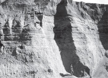
Figure 2. Deposits exposed by mudflow erosion on the North Fork of the Toutle River. The laminated and bedded pyroclastic flow deposit of June 12, 1980, is 25 feet thick in the middle of the cliff. That three-hour deposit is underlain by the pyroclastic flow deposit of May 18, 1980, and overlain by the mudflow deposit of March 19, 1982. (Photo by Steven A. Austin)
Up to 600 feet thickness of new strata have formed since 1980 at Mount St. Helens. These deposits accumulated from primary air blast, landslide, water wave on Spirit lake, pyroclastic flows, mudflows, air fall, and stream water. Perhaps the most surprising accumulations are the pyroclastic flow deposits amassed from ground-hugging, fluidized slurries of fine volcanic debris that moved at high velocities off the north flank of the volcano. These deposits include fine pumice ash laminae beds from one millimeter thick to greater than one meter thick, each representing just a few seconds to several minutes of accumulation (see “Pumice” in figure 1).
Figure 2 shows 25 feet of the stratified deposit accumulated within three hours during the evening of June 12, 1980. It was deposited from pyroclastic flows generated by collapse of the eruption plume of debris over the volcano. The strata are very extensive and even contain thin laminae and crossbedding. Within the pyroclastic flow deposits are very thin laminae. It staggers the mind to think how the finest stratification has formed in an event of the violence of a hurricane. Coarse and fine sediment were separated into distinct strata by the catastrophic flow process from a slurry moving at freeway speed. Conventionally, sedimentary laminae and beds are assumed to represent longer seasonal variations—or annual changes—as the layers accumulated very slowly. That is the typical uniformitarian interpretation. Furthermore, our natural way of thinking about catastrophic sedimentary process is that it homogenizes materials depositing coarse and fine together without obvious stratification. Mount St. Helens teaches us that stratification does form very rapidly by flow processes.
Rapid Erosion
What is exceptional at Mount St. Helens is the variety of new erosion features and their concentration within a limited and intensely studied area.
If we reason from our everyday experience concerning the way rivers and creeks erode, we might assume that great time periods are needed to form deep canyons. At Mount St. Helens, however, very rapid erosion has occurred since the 1980 eruptions. These erosion features challenge our way of thinking about how landscapes form. What is exceptional at Mount St. Helens is the variety of new erosion features and their concentration within a limited and intensely studied area. There is no place in the blast zone at Mount St. Helens where the effects of recent erosion cannot be seen. That is what makes Mount St. Helens extraordinary! Scientists discovered that the kinds of processes causing erosion were as varied as the different features formed. The major agents of erosion unleashed at Mount St. Helens are listed in summary here.
- Direct blast—the 20-megaton TNT equivalent, northward-directed steam blast of May 18 caused hot gas and rock fragments to abrade slopes around the mountain.
- Pyroclastic flows—explosive blasts on and after May 18 created superheated, erosive “rivers” of ground-hugging volcanic ash and steam.
- Debris avalanche—the movement of great masses of rock, ice, and debris over the earth’s surface next to the volcano caused significant abrasion.
- Mudflows—viscous streams of mud gouged out soft volcanic ash deposits and, to our astonishment, even the hardest rocks to form new canyons.
- Water in channels—overland flow of floodwater caused extraordinary rill and gully patterns to appear, even in nearly level slopes.
- Water waves—enormous water waves generated in Spirit Lake by the avalanche on May 18 inflicted severe erosion on slopes adjacent to the lake.
- Jetting steam—eruptions of steam from buried glacier ice reamed holes through hot volcanic ash deposits, forming distinctive explosion pits.
- Mass wasting—gravitational collapse induced significant changes to unstable slopes, especially those areas sculptured by other agents, leaving behind a varied landscape.
Two-thirds cubic mile of landslide and eruption debris from May 18, 1980, occupies 23 square miles of the North Fork of the Toutle River north and west of the crater (see figure 1). It was the largest debris avalanche observed in human history! This debris was deposited across the entire width of the valley along the uppermost 16 miles of the North Fork of the Toutle River. These deposits average 150 feet in thickness and form a hummocky surface that blocks the pre-1980 channel. Before the May 18 eruption, Spirit Lake had an outlet river draining westward into the Pacific Ocean.
From May 18, 1980, to March 19, 1982, the upper drainage area of the debris avalanche deposit was not connected to the Pacific Ocean, and water from Spirit Lake basin and the crater of the volcano did not connect to the Toutle River, due to debris blocking the valley. Because of this debris, there has been no natural outlet formed for Spirit Lake.
An explosive eruption of Mount St. Helens on March 19, 1982, melted a thick snowpack in the crater, creating a destructive, sheet-like flood of water, which became a mudflow. Breaching the deposits on the upper North Fork of the Toutle River (see “Breach” in figure 1). The most significant erosion occurred in the biggest steam explosion pit. The mudflow filled the big steam explosion pit with mud, which then overflowed the west rim of the pit as a deep ravine was cut into the 1980 deposits to the west.
The flow formed channels over much of the hummocky rockslide debris, allowing cataracts to erode headward, and established for the first time since 1980 a dendritic integration of channels on the Toutle’s North Fork drainage. Erosion has occurred intermittently since then, but most of the streams were established in their present channel locations on March 19, 1982. Figure 2 is within the breach formed by the big mudflow that day. Bedrock was eroded up to 600 feet deep to form Step Canyon and Loowit Canyon on the north flank of the volcano (see “Canyons” in figure 1).
The “Little Grand Canyon of the Toutle River” is a 1/40th-scale model of the real Grand Canyon of Arizona.
Individual canyons on the debris avalanche deposit have a depth of up to 140 feet and are cut through landslide debris and pumice from pyroclastic flows (see “Breach” in figure 1). That erosion left elevated plateaus north and south of a great breach, resembling the north and south rims of the Colorado River. Also, gully-headed side canyons and amphitheater-headed side canyons in the breach resemble side canyons in the Grand Canyon. The breach did not occur straight through the obstruction but has a meandering path, which reminds us of the meandering path of the Grand Canyon through the high plateaus of northern Arizona. The “Little Grand Canyon of the Toutle River” is a 1/40th-scale model of the real Grand Canyon of Arizona.
Small creeks that flow through the headwaters of the Toutle River today might seem, by present appearances, to have carved these canyons very slowly over a very long time period, except for the fact that the erosion was observed to have occurred rapidly! Geologists should learn that because the long time scale they have been trained to assign to landform development would lead to obvious error at Mount St. Helens, it also may be useless or misleading elsewhere.
Rapid Formation of Fossil Deposits
One million logs floated on Spirit Lake on the late afternoon of May 18, 1980, after they were uprooted and washed into the basin by the 860-foot-high water waves. Careful observation of the floating conifer logs in the lake indicates that such logs show a strong tendency to float upright, best seen from the eastern shore of the lake (see “Logs” in figure 1). Many upright deposited logs possess roots attached to the log, but many have no root ball, and those without roots also show strong tendency to float upright. It appears that the root end of these logs is denser wood and perhaps floods with water more easily, allowing the root ends to sink before the top of the log. All six of the common conifer species were observed to float in an upright position.
Hundreds of upright, fully submerged logs were located by sidescan sonar, and scuba divers verified that they were indeed trunks of trees that the sonar detected. It was estimated that 20,000 upright stumps existed on the floor of the lake in August 1985. It would appear that about ten percent of the deposited logs were in an upright position. If Spirit Lake were drained, the bottom would look like a forest of trees. These, however, did not grow where they are now, but have been replanted!
Direct application of the Spirit Lake logs may be made to the Yellowstone petrified forests.
Scuba investigation of the upright-deposited logs shows that some are already solidly buried by sedimentation with more than three feet of sediment around their bases. Others, however, have none. This proves that the upright logs were deposited at different times, with their roots buried at different levels. If found buried in the rock strata, logs such as the ones in Spirit Lake might be interpreted as multiple forests that grew on different levels over periods of many thousands of years. The Spirit Lake upright-deposited logs, therefore, have considerable implications for interpreting “petrified forests” in the strata record. Direct application of the Spirit Lake logs may be made to the Yellowstone petrified forests. There at Yellowstone, at Specimen Ridge, geologists have commonly attributed the petrified upright logs to many thousands of years of forest growth, but the upright logs in Spirit Lake call that interpretation into question.
Rapid Formation of Peat Layer
The enormous log mat floating on Spirit Lake has lost its bark and branches by the abrasive action of wind and waves. Scuba investigations of the lake bottom showed that water-saturated sheets of conifer bark are especially abundant intermingled with volcanic sediment added from the lake shore, forming a layer of peat many inches thick. The peat shows coarse texture. The primary component is sheets of tree bark, which comprise about 25 percent, by volume, of the peat. Scuba divers recovered sheets of tree bark having lengths of greater than eight feet from the peat bed. Together with broken branch and root material, bark sheets impart the peat’s noteworthy coarse texture and dominantly layered appearance.
The “Spirit Lake peat” contrasts strongly with peats that have accumulated in swamps.
The “Spirit Lake peat” contrasts strongly with peats that have accumulated in swamps. Typical swamp peats are very finely macerated by organic degradation processes. They are “coffee grounds to mashed potatoes” in general texture. Furthermore, swamp peats possess a homogeneous appearance because of the intense penetration of roots which dominate swamps. Root material is the dominant coarse component of modern swamp peats while bark sheets are extremely rare.
The Spirit Lake peat resembles, both compositionally and texturally, certain coal beds of the eastern United States, which also are dominated by tree bark and appear to have accumulated beneath floating log mats. Conventionally, coal is supposed to have accumulated from organic material built up in swamps by growth in place of plants. Because the accumulation of peat in swamps is a slow process, geologists have supposed that coal beds required about one thousand years to form each inch of coal. The peat layer in Spirit Lake reveals that “floating mat peat” can accumulate very rapidly and possesses textures resembling coal. Swamp peats, however, possess very rare bark-sheet material, because the intrusive action of tree roots disintegrates and homogenizes the peat. The Spirit Lake peat, in contrast, is texturally very similar to coal. Thus, at Spirit Lake, we may have seen the first stage in the formation of coal.
Conclusion
Mount St. Helens provides a rare opportunity to study transient geologic processes which, produced within a few months, changes what geologists might otherwise assume required many thousands of years. The volcano challenges our way of thinking about how the earth works, how it changes, and the time scale attached. These processes and their effects allow Mount St. Helens to serve as a miniature laboratory for catastrophism.
Mount St. Helens “speaks” directly to issues of our day.
Catastrophism is documented as a viable theory of geologic change and may have far-reaching implications on other scientific disciplines and philosophical inquiries. Many scientists recognize that Darwin’s theory (which assumed slow evolutionary change) may be in error. Darwin built his theory of the evolution of living things on the notion that earth has slowly evolved. With catastrophism, we have tools to interpret the stratigraphic record including the geologic evidence of the Genesis Flood. Mount St. Helens “speaks” directly to issues of our day.
Creationists have been intensely interested in the geologic formations at Mount St. Helens because they provide a very graphic and real explanation for features which are often supposed to support evolutionary theory and uniformitarian speculation. Mount St. Helens can also be used as a steppingstone to help us imagine what the Genesis Flood was like.
Bibliography
Arct, M.A., and A.V. Chadwick, “Dendrochronology in the Yellowstone Fossil Forest,” Geological Society of America, Abstracts with Programs 15 (1983): 5.
Austin, S.A., “Depositional Environment of the Kentucky No. 12 Coal Bed (Middle Pennsylvanian) of Western Kentucky, with Special Reference to the Origin of Coal Lithotypes,” Ph.D. dissertation, Pennsylvania State University, 1979, p. 411.
Austin, S.A., “Uniformitarianism—A Doctrine That Needs Rethinking,” Compass 56 no. 2 (1979): 29–45.
Austin, S.A., “Rapid Erosion at Mount St. Helens,” Origins 11 no. 2 (1984): 90–98.
Austin, S.A., Catastrophes in Earth History: A Source Book of Geologic Evidence, Speculation, and Theory, Technical Monograph No. 13 (El Cajon, CA: Institute for Creation Research, 1984).
Austin, S.A., “Floating Logs and Log Deposits of Spirit Lake, Mount St. Helens Volcano National Monument, Washington,” Geological Society of America, Abstracts with Programs 23 (1991).
Austin, S.A., “The Dynamic Landscape on the North Flank of Mount St. Helens” in J.E. O’Connor, R.J. Dorsey, and I.P. Madlin, eds., “Volcanoes to Vineyards: Geologic Field Trips through the Dynamic Landscape of the Pacific Northwest,” Geological Society of America Field Guide 15 (2009).
Chadwick, A.D., and T. Yamoto, “A Paleoecological Analysis of the Petrified Trees in the Specimen Creek Area of Yellowstone National Park, Montana, U.S.A.,” Paleogeography, Palaeoclimatology, Palaeoecology 45 (1984): 39–48.
Coffin, H.G., “Mount St. Helens and Spirit Lake,” Origins 10 (1983): 9–17.
Coffin, H.G., “Erect Floating Stumps in Spirit Lake, Washington,” Geology 11 (1983): 298–299.
Coffin, H.G., “Sonar and Scuba Survey of a Submerged Allochthonous Forest in Spirit Lake, Washington,” Palaios 2 (1987): 178–180.
Criswell, C.W., “Chronology and Pyroclastic Stratigraphy of the May 18, 1980, Eruption of Mount St. Helens, Washington,” Journal of Geophysical Research 92 (1987): 10,237–10, 266.
Foxworthy, B.L., and M. Hill, “Volcanic Eruptions of 1980 at Mount St. Helens—The First 100 Days,” United States Geological Survey Professional Paper 1249: 1982.
Fritz, W.J., “Reinterpretation of the Depositional Environment of the Yellowstone Fossil Forests.” Geology 8 (1980): 309–313.
Glicken, H., “Study of the Rockslide-Debris Avalanche of May 18, 1980, Mount St. Helens Volcano,” Ph.D. dissertation., University of California, Santa Barbara, 1986.
Hickson, C.J., “The May 18, 1980, Eruption of Mount St. Helens, Washington State: A Synopsis of Events and Review of Phase 1 from an Eyewitness Perspective,” Geoscience Canada 17 no. 3 (1990): 127–130.
Karowe, A.L., and T.M. Jefferson, “Burial of Trees by Eruptions of Mount St. Helens, Washington: Implications for the Interpretation of Fossil Forests,” Geological Magazine 124 no. 3 (1987): 191–204.
Lipman, P.O., and D.R. Mullineaux, eds., “The 1980 Eruptions of Mount St. Helens, Washington,” U.S. Geological Survey Professional Paper 1250, 1981.
Malone, S.D., “Mount St. Helens, the 1980 Re-awakening and Continuing Seismic Activity,” Geoscience Canada 17 no. 3 (1990): 163–166.
Meyer, D.F., and H.A. Martinson, “Rates and Processes of Channel development and Recovery Following the 1980 Eruption of Mount St. Helens, Washington,” Hydrological Sciences Journal 34 (1989): 115–127.
Morris, J.D., and S.A. Austin, Footprints in the Ash: The Explosive Story of Mount St. Helens (Green Forest, AR: Master Books, 2003), p. 128.
Peterson, D.W., “Overview of the Effects and Influence of the Activity of Mount St. Helens in the 1980s,” Geoscience Canada 17 (1990): 163–166.
Rosenfeld, C.L., and G.L. Beach, “Evolution of a Drainage Network: Remote Sensing Analysis of the North Fork Toutle River, Mount St. Helens, Washington,” Corvallis, Oregon State University Water Resources Research Institute, WRRI-88, 1983.
Rowley, P.D., et al., “Proximal Bedded Deposits Related to Pyroclastic Flows of May 18, 1980, Mount St. Helens, Washington,” Geological Society of America Bulletin 96 (1985): 1373–1383.
Scott, K.M., “Magnitude and Frequency of Lahars and Lahar-runout Flows in the Toutle-Cowlitz River System,” United States Geological Survey Professional Paper 1447-B, 1989.
Waitt, R.B. Jr., et al., “Eruption-Triggered Avalanche, Flood, and Lahar at Mount St. Helens—Effects of Winter Snowpack,” Science 221 (1983): 1394–1397.
Weaver, C.S., and S.D. Malone, “Overview of the Tectonic Setting and Recent Studies of Eruptions of Mount St. Helens, Washington,” Journal of Geophysical Research 92 (1987): 10, 149–10, 154.
The New Answers Book 3

Do you have answers to the big questions about the Christian faith, evolution, creation, and the biblical worldview? Now you get the important information you need regarding the existence of God, global warming and climate change, cloning and stem cells, human and chimp DNA, the importance of Mount St. Helens, and more.
Read Online Buy Book

Support the creation/gospel message by donating or getting involved!

Answers in Genesis is an apologetics ministry, dedicated to helping Christians defend their faith and proclaim the good news of Jesus Christ.
- Customer Service 800.778.3390
- © 2024 Answers in Genesis