
Chapter 18
When and How Did the Grand Canyon Form?

Join a Canyon Ministries guide and one of AiG’s speakers on a once-in-a-lifetime rafting trip and see Grand Canyon from a creationist perspective.
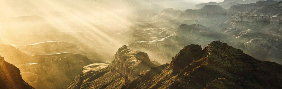
The Grand Canyon is one of the world’s most awesome erosional features. It is 277 miles (446 km) long, including the 60 miles (96 km) of Marble Canyon upstream. The depth of the main segment of the Grand Canyon varies between 3,000 and 6,000 feet (900 and 1,800 m), with the rim-to-rim width between 4 and 18 miles (6 and 29 km). Its origin has plagued geologists since the time of John Wesley Powell’s first courageous voyage down the Colorado River in 1869. Despite an increase in knowledge about its geology, evolutionary geologists have yet been unable to explain the canyon.1
Into What Was the Grand Canyon Carved?
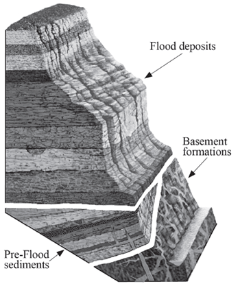
Figure 1. Grand Canyon strata diagram
Before discussing when and how the Grand Canyon was formed, it is first important to understand where and through what geologic feature it was carved. Located in northern Arizona, the Grand Canyon has been eroded through the southern end of the Colorado Plateau. Carved through sedimentary layers of sandstone, limestone, and shale and into the basement formations of mostly metamorphic schists and igneous granites, the Grand Canyon is a testimony to the erosive power of water.
But how did these rock layers first form? They can be divided into three groups as shown in figure 1. The crystalline basement formations are believed by most creation geologists to have been set in place on Day 3 of the Creation Week. The tilted pre-Flood sediment layers are up to 14,000 feet (4,260 m) in thickness, but are only exposed in the eastern canyon and in a few other areas. The upper layers—the horizontal Flood deposits—cover the entire plateau and, in some cases, the vast majority of the North American continent.2
Three Undisputed Observations
The Enormous Scale of Erosion
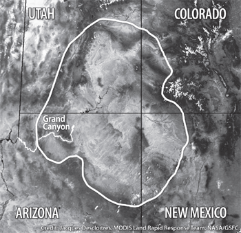
Figure 2. The extent of the Colorado Plateau
A simple calculation of the volume of the Grand Canyon reveals almost 1,000 cubic miles (4,000 cubic km) of material have been removed from northern Arizona to produce just the topographic shape of the canyon itself. However, that is not all the erosion which occurred. The Grand Canyon has been carved into a broad elevated area known as the Colorado Plateau (figure 2). The Colorado Plateau covers an area of about 250,000 square miles (647,000 square km) and consists of several smaller plateaus, which today stand at slightly varying elevations. The Kaibab Plateau, which reached more than 9,000 feet (2,740 m), forms part of the North Rim of the Grand Canyon. The sequence of sedimentary rock layers that forms these plateaus consists of many more layers than those exposed in the walls of the Grand Canyon today. In addition, to the north of the canyon there is a sequence of ascending cliffs called the Grand Staircase in which a further 10,000 feet (3,000 m) of sedimentary layers are exposed (figure 3). However, in the Grand Canyon region, most of these layers have been eroded away leaving just a few remnants, such as Red Butte (figure 4), about 16 miles (25 km) south of the South Rim of the canyon.3 The layers eroded from the Grand Staircase south to the Grand Canyon area represent an enormous volume of material, removed by sheet-like erosion over a vast area. It has been estimated that this volume of sediments eroded from the plateau was around 100,000 cubic miles (400,000 cubic km)!4

Figure 3. Cross-section through the Grand Canyon-Grand Staircase region showing the extent of the rock layers. Click for larger image.
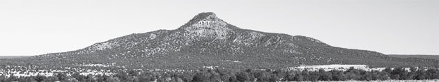
Figure 4. Red Butte
The Grand Canyon Was Cut Through the Plateau
Perhaps the most baffling observation, even to evolutionary geologists, is that the Grand Canyon cuts through, not around, a great plateau. Ranney, in his 2005 book Carving Grand Canyon: Evidence, Theories, and Mystery, said:
Oddly enough, the Grand Canyon is located in a place where it seemingly shouldn’t be. Some twenty miles east of Grand Canyon Village, the Colorado River turned sharply ninety degrees, from a southern course to a western one and into the heart of the uplifted Kaibab Plateau. . . . It appears to cut right through this uplifted wall of rock, which lies three thousand feet above the adjacent Marble Platform to the east.5
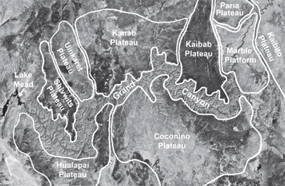
Figure 5. NASA satellite image of the Grand Canyon area, with outline of the different plateaus through which the canyon cuts.
Indeed, the headwaters of the Colorado River are at a lower elevation than the top of the Kaibab Plateau through which the Grand Canyon has been cut (figure 5).
Uplift of This Plateau Occurred Before Erosion of the Grand Canyon
This third observation also has profound implications concerning the origin of the Grand Canyon. At the eastern edge of the Kaibab Plateau, the sedimentary rock layers were bent, or as a geologist would say “folded,” along the East Kaibab Monocline at the time the plateau was uplifted. The uppermost folded layers have been beveled by erosion and overlaid by the flat-lying Wasatch Formation, which is younger.6 Furthermore, gravel deposits (from the Paleocene and Eocene epochs and thus younger than the folded Cretaceous layers) occur within channels eroded into the surface of the Kaibab Plateau, indicating the major uplift of the plateau and the accompanying erosion of its surface coincided with the uplift of the whole Colorado Plateau.7 Therefore, in evolutionary thinking the plateau is geologically “old,” and most evolutionary geologists believe its uplift occurred before erosion of the canyon into and through the plateau. But that leaves the headwaters of the Colorado River at a lower elevation than the top of that plateau, which indicates the Colorado River could not have carved the Grand Canyon!
The Secular Controversy Over When the Grand Canyon Was Eroded
Over the last 30 years, the time frame for the carving of the Grand Canyon has gone full circle.
Over the last 30 years, the time frame for the carving of the Grand Canyon has gone full circle. Thirty years ago, most evolutionists believed the canyon was about 70 million years old. But that estimate changed as radioisotope dating was utilized to show the plateau to be much older than the canyon itself. Basalts found on the North Rim near the western end of the canyon were estimated to be only 6 million years old, but these same basalts are also found on the South Rim!8 This means these lavas had to flow across from one rim to the other, a process which could not have occurred had the canyon been in place at the time. The age of at least the western Grand Canyon was thus reduced to 6 million years, but many continued to believe the central and eastern canyon was 70 million years old, based on the stream-capturing theory outlined below. Subsequently, the 70-million-year date was gradually reduced to 17 million years, based on several pieces of the puzzle indicating a younger canyon.9
New findings continue to question the age of the canyon. Some scientists still suggest 70 million years as the correct age, while others place it at less than 6 million years.10 The debate goes on, with none of the accepted dating methods providing a clear-cut answer to the age of the Grand Canyon.11
The Secular Claims About How the Canyon Was Eroded
John Wesley Powell was the first to attempt an explanation of how the Grand Canyon was formed. Known as the “antecedent river” theory, Powell theorized an ancient river eroded down into the Colorado Plateau at the same rate the plateau was being uplifted.12 Although this slow, gradual process fit nicely into the ruling uniformitarian thinking, over the next 50 to 75 years it was rejected by most geologists. The fatal blow against it came with radioisotope dating of the rim rocks.
The antecedent river theory was replaced by the idea of “stream capturing.” Stream capturing suggests that through a process called headward erosion, the Grand Canyon was cut from the west through the plateau to “capture” the river, which ran a different direction at the time.13 This is the theory many evolutionary geologists hold today, but it has seen significant changes over the last 30 years.
The initial stream capturing model had the ancestral Colorado River running through Marble Canyon to the Little Colorado River drainage, where the river then took a southeasterly direction, draining east into the Rio Grande River (figure 6). Another drainage existed to the west of the plateau cutting back through the plateau. However, its headward erosion then cut eastward through about 200 miles (320 km) of the Colorado Plateau and captured the ancestral Colorado River, which then changed its flow to a westerly direction. Subsequent to this capture, the area to the southeast was uplifted so the Little Colorado River now flows into the Colorado River. This idea met its demise in part because the necessary erosional debris could not be found anywhere east of the canyon.
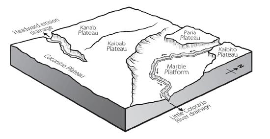
Figure 6. Ancestral Colorado River drainage flowing southeastward toward the Rio Grande
Still having the problem of the basalts on both rims of the western plateau, the theory was modified. The now widely accepted theory has the stream capturing taking place at one of the northwest-tending drainages believed to have existed prior to the plateau uplift.14 The ancestral Colorado River was thought to have taken a turn to the north, draining into the Great Salt Lake region (figure 7). Again, once the capture took place, the plateau was uplifted, causing the northwest-tending drainages to flow into the Colorado River. This modified model seems to be the predominant theory among evolutionary geologists today.
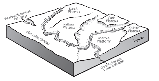
Figure 7. Ancestral Colorado River drainage flowing northwestward toward the Great Salt Lake
Evidences that Canyon Erosion Was Recent and Rapid
There are several pieces of evidence which suggest the Grand Canyon is a recent or “young” canyon. When considered individually, they are significant challenges to the uniformitarian (long-age) model; when taken as a whole, they become catastrophic. Following is a brief outline of some of those challenges.
Debris Not in the Present River Delta
Almost 1,000 cubic miles (4,000 cubic km) of material has been eroded to form the Grand Canyon. Where did it go? If the canyon was eroded by the Colorado River, an enormous delta should be found at the mouth of the river where it empties into the Gulf of California. But the delta contains only a small fraction of this eroded material.15 This same problem is found with most river deltas; they only contain enough material to represent thousands, not millions, of years of erosion.
Stable Cliffs
One of the most striking features of the Grand Canyon is the massive sheer cliffs of sedimentary rocks. It is the difference in the rocks’ makeup that gives the canyon its color and progressive stair-stepped profile of cliffs above broad slopes. The cliffs are made mostly of limestone and sandstone, with some formations reaching 500 feet (150 m) in thickness. The dark, almost black, color of large sections of the sheer cliffs is due to a coating of desert varnish, which develops slowly over many years16 and is indicative of their stability. Where recent rockfalls occur, the desert varnish is missing. The fact that the cliffs maintain their desert varnish color indicates they are rarely experiencing even minor rockfalls; thus they are very stable. This is only consistent with their formation by recent catastrophic erosion, not millions of years of slow erosion.
No Talus
The lack of debris, or talus, at the base of the cliffs is also a challenge to the evolutionary model. Over millions of years of erosion, one would expect to find large amounts of talus at the base of the cliffs within the Grand Canyon.17 The most obvious areas of this lack of talus is within the side canyons ending in broad U-shaped amphitheaters. Some of these amphitheaters are hundreds of feet deep and extend back as much as a mile (1.6 km) from the river. The majority have no water source to remove material, yet the bases of most of these cliffs are relatively “clean,” with very little talus. Within the evolutionary model, there is no mechanism for the removal of this material.
Relict Landforms
The stability of the Grand Canyon cliffs and the lack of talus at their bases are indicative of the canyon being a relict landform. In other words, the Grand Canyon has changed very little since it was carved. It is a relatively unchanged remnant or relict of the event that eroded it, which therefore could not have been today’s slow river processes extrapolated back into the past.
There are several remnants, or relict landforms, of the material that now makes up the Grand Staircase to the north of the Grand Canyon. The two most noticeable ones are Red Butte, 16 miles (25 km) south of the South Rim (see figure 4), and Cedar Mountain just east of Desert View Overlook on the South Rim. These remnants, and others like them, are mostly capped with volcanic basalt, which has protected the sedimentary layers from being eroded away. These same sedimentary layers also form the base of the San Francisco Peaks just north of Flagstaff, Arizona.
These relicts testify to a massive erosional event, which in the biblical model is explained by the receding waters of the catastrophic global Genesis Flood.
Examples of Catastrophic Erosion
Catastrophic geologic events are not generally part of the uniformitarian geologist’s thinking, but rather include events that are local or regional in size. One example of a regional event would be the 15,000 square miles (39,000 square km) of the Channeled Scablands in eastern Washington. Initially thought to be the product of slow gradual processes, this first came into question in 1923 when J. Harlen Bretz presented a paper to the Geological Society of America suggesting the Scablands were eroded catastrophically.18 For the next 30 years Bretz was ridiculed for his theory, but in 1956 additional information was presented supporting the idea. Over the next 20 years, the evidence was pieced together to show the Scablands were, in fact, catastrophically eroded by the “Spokane Flood.”19 This Spokane flood was the result of the breaching of an ice dam that had created glacial Lake Missoula. Today, the United States Geological Survey estimates the flood released 500 cubic miles (2,000 cubic km) of water, which drained in as little as 48 hours, gouging out millions of tons of solid rock.
A more recent example of the power of catastrophic processes was observed at Mount St. Helens in 1980. Two hundred million cubic yards (153 million cubic meters) of material was catastrophically deposited by volcanic flows at the base of the mountain in just a matter of hours. Less than two years later, a minor eruption caused a mudflow, which carved channels through the recently deposited material.20 These channels, which are 1/40th the size of the Grand Canyon, exposed flat contacts between the catastrophically deposited layers, contacts similar to those seen between the layers exposed in the walls of the Grand Canyon.
Both these events were relatively minor compared to a global flood. For example, the eruption of Mount St. Helens contained only 0.27 cubic miles (1.1 cubic km) of material compared to other eruptions, which have been as much as 950 cubic miles (3,960 cubic km). That is over 2,000 times the size of Mount St. Helens!
If Noah’s Flood laid down the layers rapidly . . . the boundaries between the layers would be flat and smooth.
If Noah’s Flood laid down the layers rapidly, one on top of another as was observed at Mount St. Helens, the boundaries between the layers would be flat and smooth, just as they are so magnificently displayed in the Grand Canyon. And the Channeled Scablands present a clear example of how the layers of the Grand Canyon could have easily been eroded catastrophically, possibly in a matter of just a few days.
An example of how quickly water can erode through the formations of the Grand Canyon region took place on June 28, 1983, when the pending overflow of Lake Powell required the use of the Glen Canyon Dam’s 40-foot (12-m) diameter spillway tunnels for the first time. As the volume of water increased, the entire dam started to vibrate and large boulders spewed from one of the spillways. The spillway was immediately shut down and an inspection revealed catastrophic erosion had cut through the three-foot-thick reinforced concrete walls and eroded a hole 40 feet (12 m) wide, 32 feet (10 m) deep, and 150 feet (46 m) long in the sandstone beneath the dam.21
Catastrophic erosion such as this often starts when vacuum bubbles form and implode with jackhammer-like power, eating away anything in their way. This is called cavitation.22 As volumes increase, whirlpool-like vortexes form, sucking material from the bottom in a process called kolking. That material then enters the flow and acts as projectiles, removing even more material. The erosive power of these forces continues almost exponentially as the volume of water increases. These same forces would have had a major role in the formation of the Grand Canyon.
Erosion of Grand Canyon Within the Biblical Account of Earth History
Not long after all the fossil-bearing sedimentary layers of the Colorado Plateau had been deposited by the rising Flood waters, those same waters began to recede. We are told in Psalm 104:8 that at the end of the Flood, the mountains rose and the valleys sank down, causing the waters to drain off the continents back into new ocean basins. Massive sheet erosion occurred across the plateau while it was being uplifted, carving the Grand Staircase and leaving behind the colored cliffs, canyons like Zion Canyon, and isolated remnants like Red Butte. As the Flood receded, water would have become trapped behind natural dams north and east of what is now the Grand Canyon area. Some estimate these lakes could have contained as much as 3,000 cubic miles (12,500 cubic km) of water (about three times the volume of today’s Lake Michigan).23 Figure 8 shows where one of these lakes may have been, with additional lake(s) potentially north of the Paria-Kaibito Plateau.
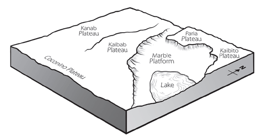
Figure 8. Natural dams trap receding Flood waters creating large lake(s).
The warming of the oceans caused by the opening of the fountains of the great deep during the Flood would also have resulted in increased rainfall in this region immediately after the Flood. Storms potentially dumped as much as 100 inches (2.5 m) of rain at a time in the area just north of the canyon.24 This rainfall would have increased the water level in the impounded lakes and would have been a powerful erosional force of its own.
As the Flood waters continued to recede, the sheet erosion across the rising Colorado Plateau would have diminished and the water would have started to channelize. This channelization would have then cut the initial path of the canyon.
The Kaibab Plateau now stands some 3,000 feet (900 m) above the adjacent Marble Platform, both part of the Colorado Plateau (figure 5). But the lack of erosional cliffs on the north and eastern sides of the Kaibab Plateau suggests that the southern end of the plateau continued to be uplifted after the rest of the region had stabilized. If this uplifting occurred just prior to, or even during, the channelization phase of the receding Flood waters, it would account for the lack of cliffs. It would also account for the direction of the side canyons eroded into the Kaibab Plateau. For example, some of the side canyons carved into the Marble Platform that join to form Marble Canyon, drain to the northeast, which seems to be the wrong direction. But that would have been the direction in which the receding waters flowed as the Kaibab Plateau was uplifted. Since the Kaibab Plateau is higher at its southern rim, this would also account for the longer and deeper side canyons carved into the North Rim of the Grand Canyon, which also follows along that southern edge of the plateau. Thus the South Rim of the canyon follows the northern edge of the Coconino Plateau (figure 5).
Within the uplifted Colorado Plateau are several limestone layers susceptible to being dissolved by surface and ground waters, as evidenced today by all the caves in the Redwall Limestone, from many of which streams flow. Because of all the volcanic activity during the Flood, the waters could have been slightly acidic, increasing their ability to dissolve limestone. So no sooner had these leftover Flood waters been dammed than they would have begun to find and exploit weaknesses in the limestone and other layers making up the plateau.
Whether it happened as the Flood year ended, or soon thereafter, the lakes would have soon breached their dams, washing over the plateau and exploiting any channels already there, rapidly carving through the plateau resulting in a deep canyon very similar to what we see today (figure 9).
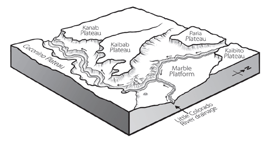
Figure 9. Current drainage of the Colorado and Little Colorado Rivers
A Few Perplexing Questions
As creationists, we do not have all the answers. In fact, there are many unanswered questions when it comes to the formation of the Grand Canyon. For example, exactly when the Kaibab Plateau was uplifted during the formation of the Grand Canyon is uncertain. Another question relates to the erosional evidence associated with the breaching of the natural dams. It is unclear as to why the waters would have eroded the course they appear to have taken, and why the remaining landscape has some of the features shown today. Also, unknown is what effect the increased rainfall in the region had on carving the canyon.
Some creationists attribute the formation of the canyon almost solely to the breaching of the dams, while others see the receding of the Flood waters to be the main carving mechanism. It is suggested here that combining the strengths of both models best explains the evidence and what we see in the Grand Canyon today.
These issues, however, do not weaken the evidence for the catastrophic carving of the Grand Canyon and its relationship to the Flood. It only shows there is still research to be done in order to better understand the canyon’s formation.
Conclusion
Although we cannot be certain of the sequence and timing of these events, the evidence shows the Grand Canyon was formed rapidly, as were the layers into which it is carved. Thus, rather than slow and gradual erosion by the Colorado River over eons of time, the Grand Canyon was carved rapidly by a lot of water in a little bit of time! The reason the Colorado River exists today is because the Grand Canyon was eroded first, soon after the end of the Genesis Flood.
The New Answers Book 3

Do you have answers to the big questions about the Christian faith, evolution, creation, and the biblical worldview? Now you get the important information you need regarding the existence of God, global warming and climate change, cloning and stem cells, human and chimp DNA, the importance of Mount St. Helens, and more.
Read Online Buy BookFootnotes
- J.W. Powell, Grand Canyon: Solving Earth’s Grandest Puzzle (New York, NY: PI Press, 2005); W. Ranney, Carving Grand Canyon: Evidence, Theories, and Mystery (Grand Canyon, AZ: Grand Canyon Association, 2005); R. Young and E. Spamer, eds., Colorado River Origin and Evolution: Proceedings of a Symposium held at Grand Canyon National Park in June 2000 (Grand Canyon, AZ: Grand Canyon Association, 2001).
- L.L. Sloss, “Sequences in the Cratonic Interior of North America,” Geological Society of America Bulletin 74 (1963): 93–114.
- T. Vail, M.J. Oard, J. Hergenrather, and D. Bokovoy, Your Guide to the Grand Canyon: A Different Perspective (Green Forest, AR: Master Books, 2008), p. 54.
- M.J. Oard, T. Vail, J. Hergenrather, and D. Bokovoy, “Formation of Rock Layers in the Grand Staircase,” in Your Guide to Zion and Bryce Canyon National Parks: A Different Perspective (Green Forest, AR: Master Books, 2010), p. 140.
- Ranney, Carving Grand Canyon: Evidence, Theories, and Mystery, p. 20.
- P.L. Babenroth and A.N. Strahler, “Geomorphology and Structure of the East Kaibab Monocline, Arizona and Utah,” Geological Society of America Bulletin 56 (1945): 107–150.
- D.P. Elston, R.A. Young, E.M. McKee, and M.L. Dennis, “Paleontology, Clast Ages, and Paleomagnetism of Upper Paleocene and Eocene Gravel and Limestone Deposits, Colorado Plateau and Transition Zone, Northern and Central Arizona,” in Geology of Grand Canyon, Northern Arizona (with Colorado River Guides), D.P. Elston, G.H. Billingsley, and R.A. Young, eds. (Washington, DC: American Geophysical Union, 1989), p. 155–173.
- I. Lucchitta, “History of the Grand Canyon and of the Colorado River in Arizona,” in Grand Canyon Geology, second edition, S.S. Beus, and M. Morales, eds. (New York, NY: Oxford University Press, 2003), p. 270–272.
- V. Polyak, C. Hill, and Y. Asmerom, “Age and Evolution of the Grand Canyon Revealed by U-Pb Dating of Water Table-type Speleotherms,” Science 319 (2008): 1377–1380.
- K.E. Karlstrom et al., “40Ar/39Ar and Field Studies of Quaternary Basalts in Grand Canyon and Model for Carving Grand Canyon: Quantifying the Interaction of River Incision and Normal Faulting Across the Western Edge of the Colorado Plateau,” Geological Society of America Bulletin 119 (2007): 1283–1312; K.E. Karlstrom et al., “Model for Tectonically Driven Incision of the Younger than 6 Ma Grand Canyon,” Geology 36 (2008): 835–838.
- A.A. Snelling, “Radiometric Dating: Problems with the Assumptions,” Answers, October–December 2009, p. 70–73.
- J.W. Powell, “Exploration of the Colorado River of the West and its Tributaries,” Smithsonian Institution Annual Report, 1875.
- E.D. McKee et al., “Evolution of the Colorado River in Arizona,” Museum of Northern Arizona Bulletin 44, 1967.
- Lucchitta, “History of the Grand Canyon and of the Colorado River in Arizona,” in Grand Canyon Geology, p. 263.
- P. Lonsdale, “Geology and Tectonic History of the Gulf of California,” in E.L. Winteren, D.M. Hussong, and R.W. Decker, eds., The Eastern Pacific Ocean and Hawaii, The Geology of North America, vol. N (Boulder, CO: Geological Society of America, 1989), p. 499–521.
- T. Liu and W.S. Broecker, “How Fast Does Rock Varnish Form?” Geology 28 no. 2 (2000): 183–186.
- E.W. Holroyd III, “Missing Talus,” Creation Research Society Quarterly 24 (1987): 15–16.
- J.H. Bretz, “Glacial Drainage of the Columbia Plateau,” Geological Society of America Bulletin 34 (1923): 573–608.
- J.E. Allen, M. Burns, and S.C. Sargent, Cataclysms of the Columbia (Portland, OR: Timber Press, 1986).
- S.A. Austin, “Rapid Erosion at Mount St. Helens,” Origins 11 (1984): 90–98.
- Challenge at Glen Canyon Dam, VHS, directed by W.L. Rusho (Denver, CO: U. S. Department of Interior, Bureau of Reclamation, 1983).
- H.L. Barnes, “Cavitation as a Geological Agent,” American Journal of Science 254 (1956): 493–505.
- S.A. Austin, “How Was Grand Canyon Eroded?” in Grand Canyon: Monument to Catastrophe, S.A. Austin, ed. (Santee, CA: Institute for Creation Research, 1994), p. 83–110; W. Brown, In the Beginning: Compelling Evidence for Creation and the Flood, sixth edition (Phoenix, AZ: Center for Scientific Creation, 1995), p. 92–95, 102–105.
- L. Vardiman, “Hypercanes Following the Genesis Flood,” in Proceedings of the Fifth International Conference on Creationism, R.L. Ivey, Jr., ed. (Pittsburgh, PA: Creation Science Fellowship, 2003), p. 17–28.


Support the creation/gospel message by donating or getting involved!

Answers in Genesis is an apologetics ministry, dedicated to helping Christians defend their faith and proclaim the good news of Jesus Christ.
- Customer Service 800.778.3390
- © 2024 Answers in Genesis