
A Catastrophic Breakup
A Scientific Look at Catastrophic Plate Tectonics
When you look at a globe, have you ever thought that the earth looks cracked? Or, maybe the continents have reminded you of a giant jigsaw puzzle, with the coastal lines of South America and Africa seeming to fit together almost perfectly.
But what did this “puzzle” of land masses look like in the past? Was the earth one big continent long ago? What caused the continents to move to their present locations? How did the global Flood of Noah’s day impact the continents?
Global investigations of the earth’s crust reveal that it has been divided by geologic processes into a mosaic of rigid blocks called “plates.” Observations indicate that these plates have moved large distances relative to one another in the past, and that they are still moving very slowly today. The word “tectonics” has to do with earth movements; so the study of the movements and interactions among these plates is called “plate tectonics.” Because almost all the plate motions responsible for the earth’s current configuration occurred in the past, plate tectonics is an interpretation or model of what geologists envisage happened to these plates through earth’s history (Figure 1).
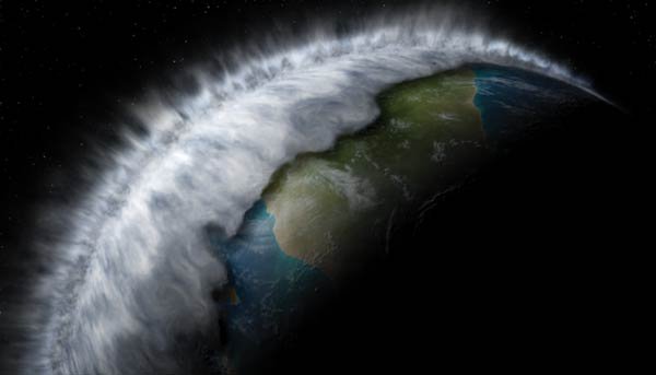
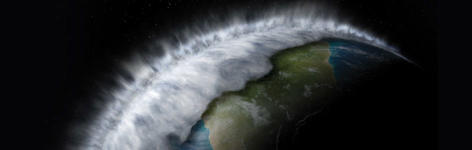
As hot mantle rock vaporizes huge volumes of ocean water, a linear column of supersonic steam jets shoot into the atmosphere. This moisture condenses in the atmosphere and then falls back to the earth as intense global rain.
Slow-and-Gradual or Catastrophic?
Most geologists believe that the movement of the earth’s plates has been slow and gradual over eons of time. If today’s measured rates of plate drift—about 0.5–6 in (2–15 cm) per year—are extrapolated into the past, it would require about 100 million years for the Atlantic Ocean to form. This rate of drift is consistent with the estimated 4.8 mi3 (20 km3) of magma that currently rises each year to create new oceanic crust.1
On the other hand, many observations are incompatible with the idea of slow-and-gradual plate tectonics. Drilling into the magnetized rock of the mid-ocean ridges shows that a matching “zebra-striped” pattern of the surface rocks does not exist at depth, as Figure 2 implies.2 Instead, magnetic polarity changes rapidly and erratically down the drill-holes. This is contrary to what would be expected with slow-and-gradual formation of the new oceanic crust accompanied by slow spreading rates. But it is just what is expected with extremely rapid formation of new oceanic crust and rapid magnetic reversals during the Flood.
Figure 1: Cross-sectional view of the earth
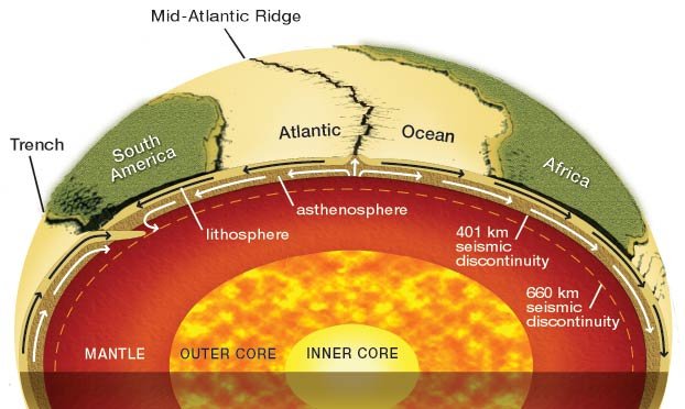
Figure 1: Cross-sectional view through the earth. The general principles of plate tectonics theory may be stated as follows: deformation occurs at the edges of the plates by three types of horizontal motion—extension (rifting or moving apart), transform faulting (horizontal shearing along a large fault line), and compression, mostly by subduction (one plate plunging beneath another).
Figure 2: Magnetic reversals
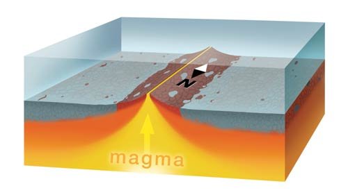
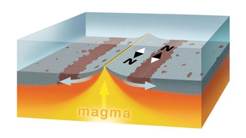
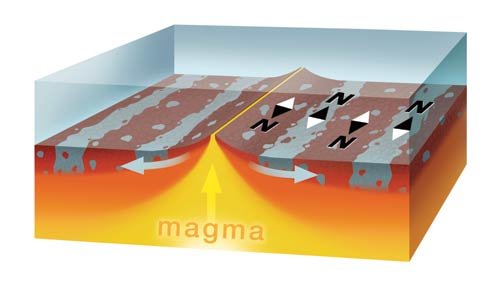
Figure 2: The magnetic pattern on the left side of the ridge matches the pattern on the right side of the ridge. Note there are “bands” of normally magnetized rock and “bands” of reversely magnetized rock. This sequence of illustrations shows how the matching pattern on each side of the mid-ocean ridge may have formed. In the Catastrophic Plate Tectonic model, the magnetic reversals would have occurred rapidly during the Flood.
Figure 3: Model of catastrophic plate tectonics after 15 days
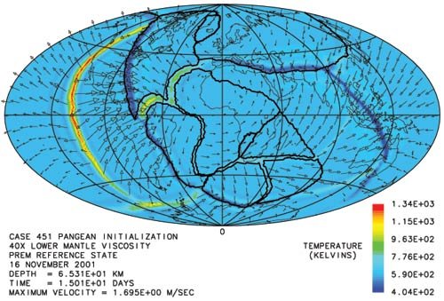
Figure 3: Snapshot of 3-D modeling solution after 15 days. The plot is an equal-area projection of a spherical mantle surface 40 mi. (65 km) below the earth’s surface in which color denotes absolute temperature. Arrows denote velocities in the plane of the cross-section. The dark lines denote plate boundaries where continental crust is present or boundaries between continent and ocean where both exist on the same plate.
Figure 4: Model of catastrophic plate tectonics after 25 days
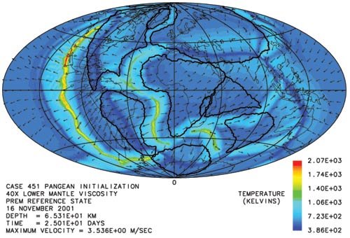
Figure 4: Snapshot of the modeling solution after 25 days. For a detailed explanation of this calculation, see Dr. Baumgardner’s paper, “The Physics behind the Flood” in Proceedings of the Fifth International Conference on Creationism, pp. 113-136, 2003.
Furthermore, slow-and-gradual subduction should have resulted in the sediments on the floors of the trenches being compressed, deformed, and faulted; yet the floors of the Peru-Chile and East Aleutian Trenches are covered with soft, flat-lying sediments devoid of compressional structures.3 These observations are consistent with extremely rapid motion during the Flood, followed by slow plate velocities as the floodwaters retreated from the continents and filled the trenches with sediment.
A catastrophic model of plate tectonics (as proposed by creation scientists) easily overcomes the problems of the slow and gradual model (as proposed by most evolutionist scientists). In addition, the catastrophic model helps us understand what the “mechanism” of the Flood may have been.4 A 3-D supercomputer model demonstrates that rapid plate movement is possible.5 Even though this model was developed by a creation scientist, this supercomputer 3-D plate tectonics modeling technique is acknowledged as the world’s best.6
Catastrophic Plate Tectonics
The catastrophic plate tectonics model of Austin et al. described in this article begins with a pre-Flood supercontinent surrounded by cold ocean-floor rocks that were denser (heavier) per unit volume than the warm mantle rock beneath.7 To initiate motion, this model requires a sudden trigger large enough to “crack” the ocean floor adjacent to the supercontinent, so that zones of cold, heavy ocean-floor rock start sinking into the upper mantle.
In this model (Figures 3 and 4), as the ocean floor (in the areas of the ocean trenches) sinks into the mantle, it drags the rest of the ocean floor with it, in a conveyor-belt-like fashion. The sinking slabs of cold ocean floor produce stress in the surrounding hot mantle rock. These stresses, in turn, cause the rock to become hotter and more deformable, allowing ocean slabs to sink even faster. The ultimate result is a runaway process that causes the entire pre-Flood ocean floor to sink to the bottom of the mantle in a matter of a few weeks. As the slabs sink (at rates of feet-per-second) down to the mantle/core boundary, enormous amounts of energy are released.8
The rapidly sinking ocean-floor slabs cause large-scale convection currents, producing a circular flow throughout the mantle. The hot mantle rock displaced by these subducting slabs wells up to the mid-ocean rift zones where it melts and forms new ocean floor. Here, the liquid rock vaporizes huge volumes of ocean water to produce a linear curtain of supersonic steam jets along the entire 43,500 mi (70,000 km) of the seafloor rift zones. Perhaps this is what is meant by the “fountains of the great deep” in Genesis 7:11. These supersonic steam jets capture large amounts of water as they “shoot” up through the ocean into the atmosphere. Water is catapulted high above the earth and then falls back to the surface as intense global rain, which is perhaps the source for the “floodgates of heaven” in Genesis 7:11.
As the ocean floor warms during this process, its rock expands, displacing sea water, forcing a dramatic rise in sea level. Ocean water would have swept up onto and over the continental land surfaces, carrying vast quantities of sediments and marine organisms with them to form the thick, fossiliferous sedimentary rock layers we now find blanketing large portions of today’s continents. Rocks like this are magnificently exposed in the Grand Canyon, for example. Slow-and-gradual plate tectonics simply cannot account for such thick, laterally extensive sequences of sedimentary strata containing marine fossils over such vast interior continental areas high above sea level.
Is Catastrophic Plate Tectonics Biblical?
The Bible does not directly mention continental drift or plate tectonics. However, if the continents were once joined together and are now apart, then the most likely time for their division was during the Flood. Some have suggested this continental division occurred after the Flood during the days of Peleg, when “the earth was divided” (Genesis 10:25). However, this Hebrew expression can also be translated to mean “lands being divided among peoples [nations],” which, according to the context, refers to the results of the Tower of Babel judgment.
Conclusion
Many creationist geologists now believe the catastrophic plate tectonics concept is very useful as the best explanation for how the Flood event occurred within the biblical framework for earth’s history. This concept is still rather new, but its explanatory power makes it compelling. Additional work is underway to further refine and detail this geologic model for the Flood event, especially to show that it provides a better scientific explanation for the order and distribution of the fossils and strata globally than the failed slow-and-gradual belief.
Adapted and condensed from Chapter 14, “Can Catastrophic Tectonics Explain Flood Geology?” New Answers Book by Dr. Andrew Snelling, November 2006.
A Short History of Plate Tectonics
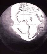
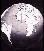
Antonio Snider’s original illustration of the continents rapidly separating during the time of the Flood.
The formerly joined continents before their separation.
The continents after the separation.
The idea that the continents have drifted apart was first suggested in 1859 by the French creationist geographer Antonio Snider.9 He theorized a supercontinent based on his interpretation of Genesis 1:9–10. He noticed a resemblance between the coastlines of western Africa and eastern South America and proposed the breakup and rapid drifting of the pieces catastrophically during the Flood (right). It wasn’t until 1915 that the theory of continental drift was acknowledged by the scientific community, partly due to the research published by German meteorologist Alfred Wegener.10 However, most geologists spurned the theory because Wegener could not provide a workable mechanism to explain how the continents could “plow” through the ocean basins.
Between 1962 and 1968 the current theory of plate tectonics was developed. Four independent observations were cited: (1) discovery of the seafloor’s dynamic topography; (2) discovery of magnetic field reversals in a “zebra-striped” pattern adjacent to the mid-ocean ridges (Figure 2); (3) the “timing” of those reversals; and (4) accurate pinpointing of the locations of earthquakes.11 Most geologists became convinced of plate tectonics during this short time because the concept elegantly explained these and other apparently unrelated observations.11
Footnotes
- Cann, J., Subtle minds and mid-ocean ridges, Nature 393:625, 627, 1998.
- Hall, J.M. and P.T. Robinson, Deep crustal drilling in the North Atlantic Ocean, Science 204:573–576, 1979.
- Scholl, D.W., M.N. Christensen, R. Von Huene, and M.S. Marlow, Peru-Chile trench sediments and seafloor spreading, Geological Society of America Bulletin 81:1339–1360, 1970; Von Huene, R., Structure of the continental margin and tectonism at the Eastern Aleutian Trench, Geological Society of America Bulletin 83:3613–3626, 1972.
- Austin, S.A., et al., Catastrophic plate tectonics: a global Flood model of earth history; in Walsh, R.E. (Ed.), Proceedings of the Third International Conference on Creationism, Creation Science Fellowship, Pittsburgh, Pennsylvania, pp. 609–621, 1994.
- Proceedings of the First, Second, Third, and Fifth International Conferences on Creationism, Creation Science Fellowship, Pittsburgh, Pennsylvania.
- Beard, J., How a supercontinent went to pieces, New Scientist 137:19, January 16, 1993.
- Ref. 5.
- The key physics responsible for the runaway instability is the fact that mantle rocks weaken under stress, by factors of a billion or more, for the sorts of stress levels that can occur in a planet the size of the earth, a behavior verified by many laboratory experiments over the past forty years. See Kirby, S. H., Rheology of the lithosphere, Reviews of Geophysics and Space Physics 25:1219–1244, 1983.
- Snider, A., Le Création et ses Mystères Devoilés, Franck and Dentu, Paris, 1859.
- Wegener, A., Die Entstehung der Kontinente und Ozeane, 1915.
Cox, A. (Ed.), Plate Tectonics and Geomagnetic Reversals, W.H. Freeman and Co., San Francisco, California, 1973.
These observations included (1) the jigsaw puzzle fit of the continents; (2) the correlation of fossils and fossil-bearing strata across oceans; (3) similar matching magnetic patterns in volcanic rocks on each side of the mid-ocean ridges (evidence of seafloor spreading); (4) non-random distribution of most earthquakes, many occurring in narrow zones defining plate boundaries; (5) earthquakes indicating that deep ocean trenches were places where ocean mantle plunged into the earth (subduction); (6) the presence of volcanic belts adjacent to deep sea trenches (e.g., the Pacific “ring of fire”); and (7) the location of mountain belts at or adjacent to places where plates collide.

Support the creation/gospel message by donating or getting involved!

Answers in Genesis is an apologetics ministry, dedicated to helping Christians defend their faith and proclaim the good news of Jesus Christ.
- Customer Service 800.778.3390
- © 2024 Answers in Genesis